$1,795
/ Month
581 Smith Cemetery Rd
Winder, GA 30680
2 Weeks Ago
|
Edit
Favorites
581 Smith Cemetery Rd

Favorites
Check Back Soon for Upcoming Availability
| Beds | Baths | Average SF |
|---|---|---|
| 2 Bedrooms 2 Bedrooms 2 Br | 2 Baths 2 Baths 2 Ba | — |
About This Property
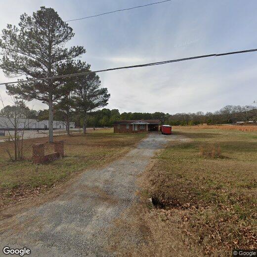
Older ranch home most recently used as office space. Very nice interior, fantastic location convenient to Winder, Jefferson and Athens. Just off 316
581 Smith Cemetery Rd is a house located in Barrow County and the 30680 ZIP Code. This area is served by the Barrow County School District attendance zone.
House Features
- Dishwasher
581 Smith Cemetery Rd,
Winder,
GA
30680
Winder is a small city in north central Georgia, located about 25 miles west of Athens and fifty miles east of Atlanta. The city features a thriving commercial district at the center of town, with cozy cafes, specialty shops, and other locally owned businesses operating out of the countless historic buildings in the area. Fort Yargo State Park occupies a large chunk of the city’s south side, with its trails and lake serving as popular destinations for locals when the weather is nice.
Learn more about living in Winder
Amenities
- Dishwasher
Education
| Colleges & Universities | Distance | ||
|---|---|---|---|
| Colleges & Universities | Distance | ||
| Drive: | 28 min | 19.9 mi | |
| Drive: | 27 min | 21.2 mi | |
| Drive: | 28 min | 21.2 mi | |
| Drive: | 31 min | 24.6 mi |
581 Smith Cemetery Rd is within 28 minutes or 21.2 miles from Piedmont College, Athens. It is also near Georgia Gwinnett College and University of Georgia.
Schools


Public Elementary School
Grades PK-5
928 Students
Attendance Zone
Public Middle School
Grades 6-8
736 Students
Attendance Zone
Public High School
Grades 9-12
1,894 Students
Attendance Zone
Private Elementary, Middle & High School
Grades PK-12
642 Students
Nearby
School data provided by
 The GreatSchools Rating helps parents compare schools within a state based on a variety of school quality indicators and provides a helpful picture of how effectively each school serves all of its students. Ratings are on a scale of 1 (below average) to 10 (above average) and can include test scores, college readiness, academic progress, advanced courses, equity, discipline and attendance data. We also advise parents to visit schools, consider other information on school performance and programs, and consider family needs as part of the school selection process.
View GreatSchools Rating Methodology
Data provided by GreatSchools.org © 2026. All rights reserved.
View GreatSchools Rating Methodology
Data provided by GreatSchools.org © 2026. All rights reserved.
Walkability Near 581 Smith Cemetery Rd Winder, GA 30680
Getting Around
 What do Walkability, Transit, Drivability, and Bikeability mean?
Walkability measures the walking distance to day-to-day needs.
Transit measures access to public transportation.
Drivability measures congestion, parking availability, and access to major roads.
Bikeability measures the suitability for cycling.
How It Works
What do Walkability, Transit, Drivability, and Bikeability mean?
Walkability measures the walking distance to day-to-day needs.
Transit measures access to public transportation.
Drivability measures congestion, parking availability, and access to major roads.
Bikeability measures the suitability for cycling.
How It Works
Not Walkable
Walkability
10
/ 100
Exceptionally Drivable
Drivability
90
/ 100
Somewhat Bikeable
Bikeability
20
/ 100
Scores provided by
-
Soundscore™
-
/ 100
Traffic
-Airport
-Businesses
-Scores provided by
HowLoud What is a Sound Score Rating? A Sound Score Rating aggregates noise caused by vehicle traffic, airplane traffic and local sources. How It WorksYou May Also Like
Similar Rentals Nearby
-
-
-
-

-
-
-
-
 Total Monthly Price New3 Beds$2,400+4 Beds$2,500+Total Monthly PricePrices include all required monthly fees.
 -
-


What Are Walk Score®, Transit Score®, and Bike Score® Ratings?
Walk Score® measures the walkability of any address. Transit Score® measures access to public transit. Bike Score® measures the bikeability of any address.
What is a Sound Score Rating?
A Sound Score Rating aggregates noise caused by vehicle traffic, airplane traffic and local sources.

581 Smith Cemetery Rd
Winder, GA 30680