
$3,000 / Month
5718 Kenfield Ln
Upper Marlboro, MD 20772
2 Weeks Ago
Favorites
5718 Kenfield Ln

Favorites
Check Back Soon for Upcoming Availability
| Beds | Baths | Average SF |
|---|---|---|
| 3 Bedrooms 3 Bedrooms 3 Br | 4 Baths 4 Baths 4 Ba | 4,654 SF |
About This Property
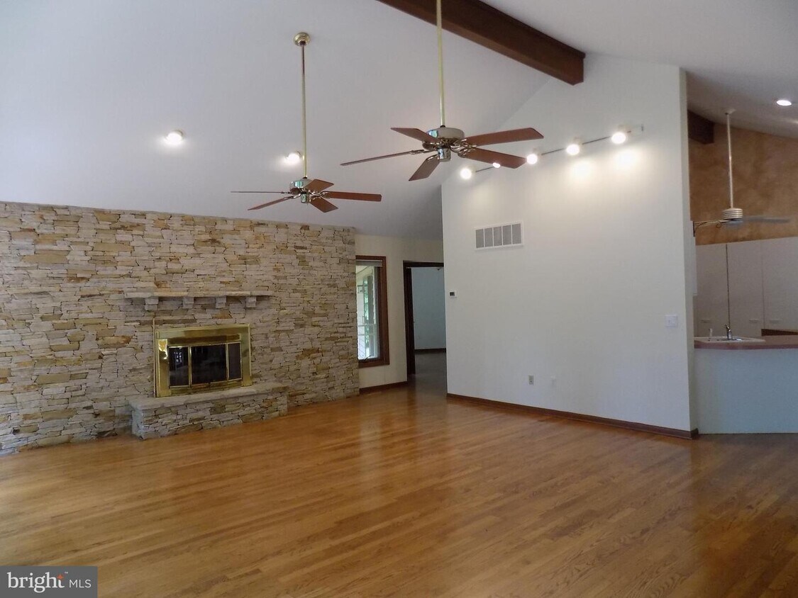
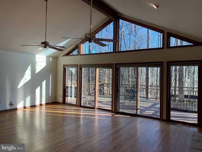
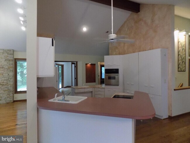
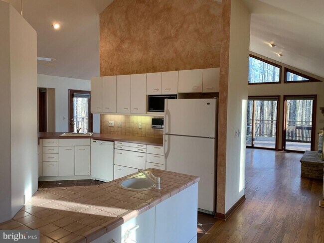
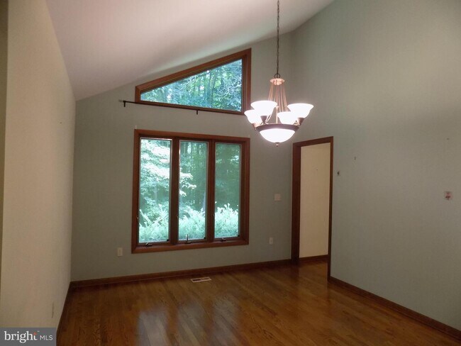
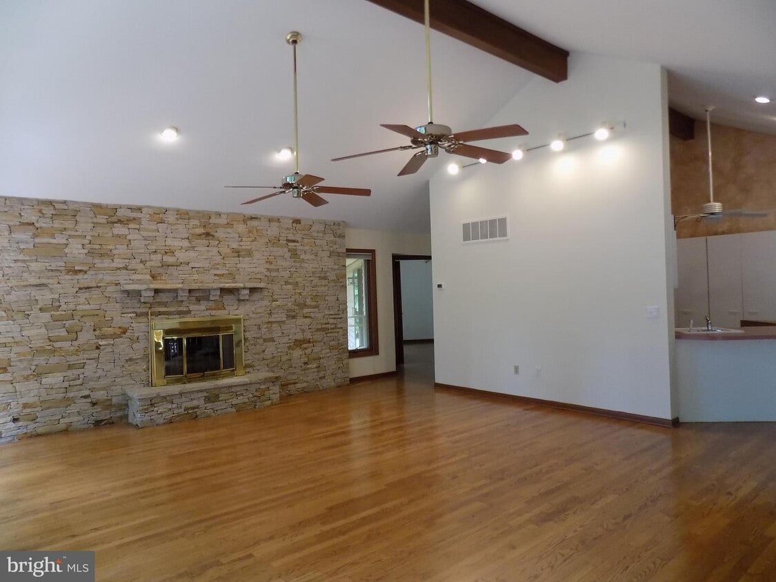
Custom built rambler with finished lower level-over 4,000 finished square feet-built for wheelchair accessibility-Open/Unique Floor Plan(please see attachments)-Den/3rd Bedroom on Main Level-4th possible bedroom with walk-in closet lower level-Awesome family room with cathedral ceilings/stone fireplace/ceiling fans & sliding glass doors to large deck-Separate dining room w/vaulted ceilings-Kitchen with double sinks/cathedral ceilings/ceramic tile floors-Breakfast nook off kitchen with bay windows-Large master bedroom with walk-in closet and hardwood floors-Oversized side load garage with concrete ramp to main level/mud room-Walkout lower level with rec room/media-storage room/workshop/3rd-4th bedroom, full bathroom and another storage room-Private cul-de-sac lot backing to trees-Large deck overlooking rear yard-enjoy winter sunsets from family room/deck
5718 Kenfield Ln is a house located in Prince George's County and the 20772 ZIP Code. This area is served by the Prince George's County Public Schools attendance zone.
House Features
- Fireplace
- Dishwasher
- Basement
Location
Get Directions
Popularly known as a government district in Prince George’s County in the state of Maryland, Upper Marlboro offers residents a small-town vibe. Lined with an assortment of businesses, Main Street provides immediate access to the courthouse and county administrative building.
You'll find a combination of busy thoroughfares within the city and a quiet atmosphere in the residential suburbs. To the west of downtown are residential homes on quiet streets with mostly single-family homes, parks, and civic centers. Take a short walk from Main Street to access the Prince George’s County Public system. Aside from the few grocery stores and big-box retailers, the rural nature of the area is the biggest draw for residents. But it also means you might have to head to surrounding areas for more shopping and restaurant options.
Learn more about living in Greater Upper MarlboroBelow are rent ranges for similar nearby apartments
Amenities
- Fireplace
- Dishwasher
- Basement
Education
| Colleges & Universities | Distance | ||
|---|---|---|---|
| Colleges & Universities | Distance | ||
| Drive: | 20 min | 10.2 mi | |
| Drive: | 21 min | 11.8 mi | |
| Drive: | 29 min | 15.5 mi | |
| Drive: | 29 min | 15.5 mi |
5718 Kenfield Ln is within 20 minutes or 10.2 miles from Prince George's Comm. Coll.. It is also near Univ. of Md. Univ. Coll. and Georgetown.
Schools


Public Elementary School
Grades PK-5
309 Students
Attendance Zone
Public Middle School
Grades 6-8
711 Students
Attendance Zone
Public High School
Grades 9-12
2,257 Students
Attendance Zone
Private Elementary, Middle & High School
Grades PK-12
183 Students
Nearby
School data provided by
 The GreatSchools Rating helps parents compare schools within a state based on a variety of school quality indicators and provides a helpful picture of how effectively each school serves all of its students. Ratings are on a scale of 1 (below average) to 10 (above average) and can include test scores, college readiness, academic progress, advanced courses, equity, discipline and attendance data. We also advise parents to visit schools, consider other information on school performance and programs, and consider family needs as part of the school selection process.
View GreatSchools Rating Methodology
Data provided by GreatSchools.org © 2025. All rights reserved.
View GreatSchools Rating Methodology
Data provided by GreatSchools.org © 2025. All rights reserved.
Transportation options available in Upper Marlboro include Suitland, located 9.8 miles from 5718 Kenfield Ln. 5718 Kenfield Ln is near Ronald Reagan Washington Ntl, located 19.1 miles or 35 minutes away, and Baltimore/Washington International Thurgood Marshall, located 34.3 miles or 54 minutes away.
| Transit / Subway | Distance | ||
|---|---|---|---|
| Transit / Subway | Distance | ||
|
|
Drive: | 20 min | 9.8 mi |
|
|
Drive: | 20 min | 10.2 mi |
|
|
Drive: | 20 min | 10.4 mi |
|
|
Drive: | 20 min | 11.2 mi |
|
|
Drive: | 21 min | 11.3 mi |
| Commuter Rail | Distance | ||
|---|---|---|---|
| Commuter Rail | Distance | ||
| Drive: | 26 min | 15.5 mi | |
|
|
Drive: | 26 min | 15.5 mi |
|
|
Drive: | 28 min | 15.7 mi |
|
|
Drive: | 27 min | 15.8 mi |
|
|
Drive: | 29 min | 15.9 mi |
| Airports | Distance | ||
|---|---|---|---|
| Airports | Distance | ||
|
Ronald Reagan Washington Ntl
|
Drive: | 35 min | 19.1 mi |
|
Baltimore/Washington International Thurgood Marshall
|
Drive: | 54 min | 34.3 mi |
Time and distance from 5718 Kenfield Ln.
| Shopping Centers | Distance | ||
|---|---|---|---|
| Shopping Centers | Distance | ||
| Drive: | 8 min | 3.2 mi | |
| Drive: | 10 min | 3.8 mi | |
| Drive: | 10 min | 3.9 mi |
5718 Kenfield Ln has 3 shopping centers within 3.9 miles, which is about a 10-minute drive. The miles and minutes will be for the farthest away property.
| Parks and Recreation | Distance | ||
|---|---|---|---|
| Parks and Recreation | Distance | ||
|
School House Pond
|
Drive: | 7 min | 2.8 mi |
|
Cheltenham Wetlands Park
|
Drive: | 10 min | 4.5 mi |
|
Rosaryville State Park
|
Drive: | 15 min | 6.7 mi |
|
Jug Bay Natural Area
|
Drive: | 23 min | 8.0 mi |
|
Mount Calvert Historical and Archaeological Park
|
Drive: | 24 min | 8.0 mi |
5718 Kenfield Ln has 5 parks within 8.0 miles, including School House Pond, Cheltenham Wetlands Park, and Rosaryville State Park.
| Hospitals | Distance | ||
|---|---|---|---|
| Hospitals | Distance | ||
| Drive: | 18 min | 8.5 mi |
5718 Kenfield Ln is 8.5 miles and a 18 minute drive from MedStar Southern Maryland Hospital Center.
| Military Bases | Distance | ||
|---|---|---|---|
| Military Bases | Distance | ||
| Drive: | 16 min | 7.6 mi | |
| Drive: | 26 min | 13.9 mi |
5718 Kenfield Ln is 7.6 miles from Andrews Airforce Base, and is convenient to other military bases, including Washington Navy Yard.
You May Also Like
Similar Rentals Nearby


What Are Walk Score®, Transit Score®, and Bike Score® Ratings?
Walk Score® measures the walkability of any address. Transit Score® measures access to public transit. Bike Score® measures the bikeability of any address.
What is a Sound Score Rating?
A Sound Score Rating aggregates noise caused by vehicle traffic, airplane traffic and local sources
5718 Kenfield Ln
Upper Marlboro, MD 20772