


$1,850
/ Month
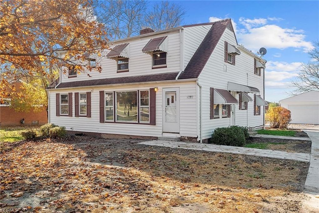
5702 Perkins Rd
Bedford Heights, OH 44146
2 Weeks Ago
|
Edit
Favorites
5702 Perkins Rd

Favorites
Check Back Soon for Upcoming Availability
| Beds | Baths | Average SF |
|---|---|---|
| 5 Bedrooms 5 Bedrooms 5 Br | 3 Baths 3 Baths 3 Ba | 3,586 SF |
Fees and Policies
The fees listed below are community-provided and may exclude utilities or add-ons. All payments are made directly to the property and are non-refundable unless otherwise specified.
- Parking
-
Garage--
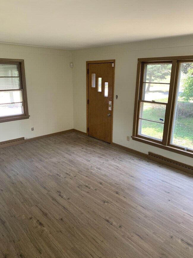
About This Property
Very Unique Home. Newly updated, on a large lot in town. 2 car garage, hobby shed, and pavilion!!
5702 Perkins Rd is a house located in Cuyahoga County and the 44146 ZIP Code. This area is served by the Bedford City School District attendance zone.
House Features
- Fireplace
5702 Perkins Rd,
Bedford Heights,
OH
44146
Brandon sits just east of Jackson as the county seat of Rankin County, carrying more than 190 years of Mississippi history while maintaining a steady suburban pace. Named for Gerard Brandon, an early governor of the state, the city was incorporated in 1831 and has grown into a well-established part of the greater Jackson metropolitan area. State government positions, major medical centers, and institutions like Millsaps College are all within a reasonable commute, giving residents access to a broad employment base without living in the capital itself. The Natchez Trace Parkway runs nearby for outdoor recreation, and the Ross Barnett Reservoir offers boating and fishing just minutes from town. Downtown Brandon retains a small-city character, with local theater productions and community events drawing residents throughout the year.
Learn more about living in Bedford Heights
Amenities
- Fireplace
Education
| Colleges & Universities | Distance | ||
|---|---|---|---|
| Colleges & Universities | Distance | ||
| Drive: | 8 min | 3.9 mi | |
| Drive: | 9 min | 5.1 mi | |
| Drive: | 16 min | 7.8 mi | |
| Drive: | 15 min | 9.3 mi |
5702 Perkins Rd is within 8 minutes or 3.9 miles from Cuyahoga C.C., East. It is also near Cuyahoga C.C., Eastern Campus and John Carroll University.
Schools


Public Elementary School
Grades PK-5
Nearby
Public Elementary & Middle School
Grades K-8
Nearby
Public Elementary School
Grades K-5
Nearby
Public Middle School
Grades 6-8
Nearby
Public High School
Grades 9-12
Attendance Zone
Private Elementary School
Grades K-5
Nearby
Private Elementary & Middle School
Grades K-8
Nearby
Private High School
Grades 9-12
Nearby
School data provided by
 The GreatSchools Rating helps parents compare schools within a state based on a variety of school quality indicators and provides a helpful picture of how effectively each school serves all of its students. Ratings are on a scale of 1 (below average) to 10 (above average) and can include test scores, college readiness, academic progress, advanced courses, equity, discipline and attendance data. We also advise parents to visit schools, consider other information on school performance and programs, and consider family needs as part of the school selection process.
View GreatSchools Rating Methodology
Data provided by GreatSchools.org © 2026. All rights reserved.
View GreatSchools Rating Methodology
Data provided by GreatSchools.org © 2026. All rights reserved.
Transportation options available in Bedford Heights include Warrensville (Blue Line), located 5.5 miles from 5702 Perkins Rd. 5702 Perkins Rd is near Cleveland-Hopkins International, located 20.5 miles or 31 minutes away, and Akron-Canton Regional, located 38.4 miles or 50 minutes away.
| Transit / Subway | Distance | ||
|---|---|---|---|
| Transit / Subway | Distance | ||
|
|
Drive: | 9 min | 5.5 mi |
|
|
Drive: | 10 min | 6.1 mi |
|
|
Drive: | 10 min | 6.3 mi |
|
|
Drive: | 11 min | 6.4 mi |
|
|
Drive: | 13 min | 7.2 mi |
| Commuter Rail | Distance | ||
|---|---|---|---|
| Commuter Rail | Distance | ||
| Drive: | 17 min | 7.8 mi | |
| Drive: | 17 min | 8.2 mi | |
| Drive: | 23 min | 12.4 mi | |
|
Boston Mill
|
Drive: | 24 min | 15.3 mi |
| Drive: | 24 min | 17.1 mi |
| Airports | Distance | ||
|---|---|---|---|
| Airports | Distance | ||
|
Cleveland-Hopkins International
|
Drive: | 31 min | 20.5 mi |
|
Akron-Canton Regional
|
Drive: | 50 min | 38.4 mi |
Walkability Near 5702 Perkins Rd Bedford Heights, OH 44146
Getting Around
 What do Walkability, Transit, Drivability, and Bikeability mean?
Walkability measures the walking distance to day-to-day needs.
Transit measures access to public transportation.
Drivability measures congestion, parking availability, and access to major roads.
Bikeability measures the suitability for cycling.
How It Works
What do Walkability, Transit, Drivability, and Bikeability mean?
Walkability measures the walking distance to day-to-day needs.
Transit measures access to public transportation.
Drivability measures congestion, parking availability, and access to major roads.
Bikeability measures the suitability for cycling.
How It Works
Fairly Walkable
Walkability
40
/ 100
Limited Public Transit
Transit
30
/ 100
Exceptionally Drivable
Drivability
100
/ 100
Fairly Bikeable
Bikeability
50
/ 100
Scores provided by
-
Soundscore™
-
/ 100
Traffic
-Airport
-Businesses
-Scores provided by
HowLoud What is a Sound Score Rating? A Sound Score Rating aggregates noise caused by vehicle traffic, airplane traffic and local sources. How It WorksTime and distance from 5702 Perkins Rd.
| Shopping Centers | Distance | ||
|---|---|---|---|
| Shopping Centers | Distance | ||
| Walk: | 6 min | 0.3 mi | |
| Drive: | 4 min | 1.9 mi | |
| Drive: | 4 min | 2.2 mi |
5702 Perkins Rd has 3 shopping centers within 2.2 miles, which is about a 4-minute drive. The miles and minutes will be for the farthest away property.
| Parks and Recreation | Distance | ||
|---|---|---|---|
| Parks and Recreation | Distance | ||
|
South Chagrin Reservation
|
Drive: | 10 min | 4.9 mi |
|
Bedford Reservation
|
Drive: | 15 min | 6.3 mi |
|
Garfield Park Nature Center
|
Drive: | 11 min | 6.6 mi |
|
Nature Center at Shaker Lakes
|
Drive: | 14 min | 8.5 mi |
|
Acacia Reservation
|
Drive: | 13 min | 8.7 mi |
5702 Perkins Rd has 5 parks within 8.7 miles, including Bedford Reservation, South Chagrin Reservation, and Garfield Park Nature Center.
| Hospitals | Distance | ||
|---|---|---|---|
| Hospitals | Distance | ||
| Drive: | 8 min | 4.4 mi | |
| Drive: | 7 min | 4.5 mi | |
| Drive: | 9 min | 4.9 mi |
5702 Perkins Rd has 3 hospitals within 4.9 miles, the nearest is South Pointe Hospital which is 4.4 miles away and a 8 minute drive.
| Military Bases | Distance | ||
|---|---|---|---|
| Military Bases | Distance | ||
| Drive: | 95 min | 80.1 mi |
5702 Perkins Rd is 80.1 miles and a 95 minute drive from Mansfield Lahm Airport Air Guard Station.
You May Also Like
Similar Rentals Nearby


What Are Walk Score®, Transit Score®, and Bike Score® Ratings?
Walk Score® measures the walkability of any address. Transit Score® measures access to public transit. Bike Score® measures the bikeability of any address.
What is a Sound Score Rating?
A Sound Score Rating aggregates noise caused by vehicle traffic, airplane traffic and local sources.

5702 Perkins Rd
Bedford Heights, OH 44146