

$2,200
/ Month
5675 Laurel Ridge Cir
East Point, GA 30344
Today
|
Edit
Favorites
404-445-7783
-
Bedrooms
4
-
Bathrooms
2.5
-
Square Feet
1,866 sq ft
-
Available
Available Now
5675 Laurel Ridge Cir

Favorites
About This Home
Available Now
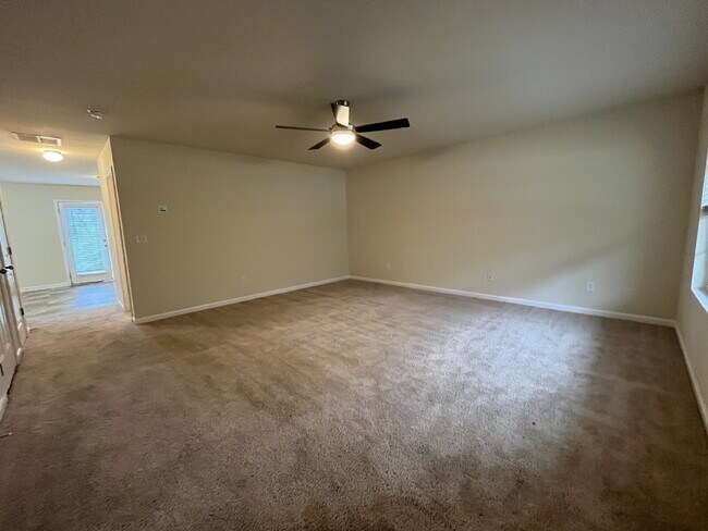
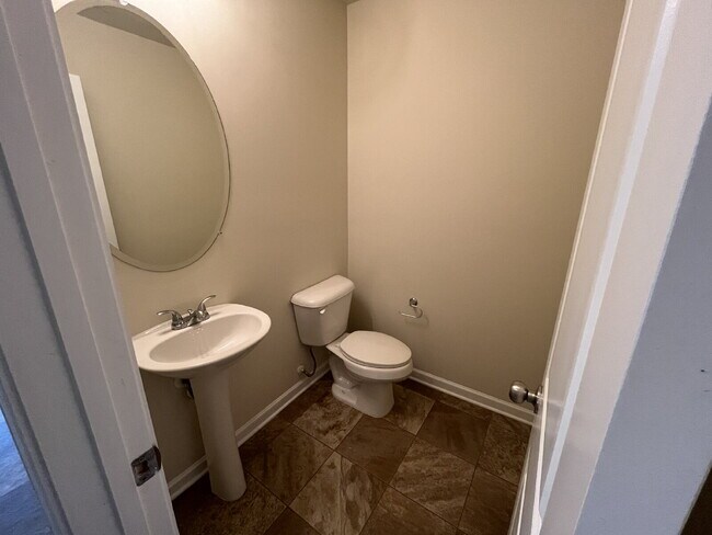
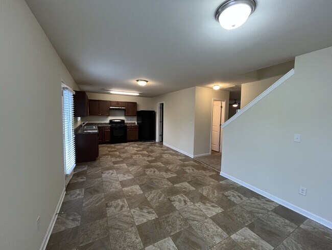
Live in Style in Vibrant East Point near Camp Creek Marketplace and more! Don't miss this opportunity to rent a beautiful, modern home built in 2019. Perfectly blending urban convenience with comfortable living, this property offers all the benefits of new construction without the wait. This 4 Bedroom, 2.5 Bathroom home features a desirable open-concept floor plan, ideal for entertaining and daily life.This home offers plenty of space and comfort. Laundry room is upstairs. Walk in pantry. Partial bath downstairs & guest bath upstairs are very spacious. Double vanity in primary bath. Ample-sized living/family room. Oversized, long driveway. Location: Situated in the heart of East Point, you are minutes away from the thriving downtown area, local parks, dining spots, and shopping. Commuting is a breeze with quick access to major highways, Hartsfield-Jackson Atlanta International Airport, and MARTA stations, offering seamless connectivity to all of Atlanta. Experience the perfect balance of suburban tranquility and city access. Schedule your showing today! Resident Benefits Package (RBP): PMI Beltline residents are enrolled in the RBP for $47.45/month, which provides a convenient option for renters insurance, HVAC air filter delivery (for applicable properties), credit building to boost your credit score with timely rent payments, $1M Identity Protection, move-in concierge service to make utility connection a breeze, our best-in-class resident rewards program, and much more! More details will be provided upon application.
5675 Laurel Ridge Cir is an apartment community located in Fulton County and the 30344 ZIP Code.
* Price shown is base rent. Excludes user-selected optional fees and variable or usage-based fees and required charges due at or prior to move-in or at move-out. Price, availability, fees, and any applicable rent special are subject to change without notice.
* Square footage definitions vary. Displayed square footage is approximate.
Features
Air Conditioning
Dishwasher
Washer/Dryer Hookup
Refrigerator
- Washer/Dryer Hookup
- Air Conditioning
- Ceiling Fans
- Smoke Free
- Dishwasher
- Refrigerator
- Carpet
- Window Coverings
- Patio
- Lawn
Contact
- Listed by PMI Beltline
- Phone Number
- Contact
Location
Get Directions
Amenities
- Washer/Dryer Hookup
- Air Conditioning
- Ceiling Fans
- Smoke Free
- Dishwasher
- Refrigerator
- Carpet
- Window Coverings
- Patio
- Lawn
Aerotropolis refers to an array of Southside Atlanta communities surrounding Hartsfield-Jackson Atlanta International Airport, the world’s busiest airport. The cities of College Park, Chattahoochee Hills, East Point, Fairburn, Forest Park, Union City, Hapeville, Morrow, and Palmetto are all a part of the Aerotropolis Alliance, working together on initiatives to improve their respective communities.
Aerotropolis’ close proximity to the airport makes the region an ideal choice for local employees and frequent travelers alike. A wide variety of rentals are available throughout the region, from luxury apartments and cozy condos to charming townhomes and spacious houses. Getting around from Aerotropolis is easy with access to I-75, I-85, and I-285.
Learn more about living in Aerotropolis
Education
| Colleges & Universities | Distance | ||
|---|---|---|---|
| Colleges & Universities | Distance | ||
| Drive: | 16 min | 9.9 mi | |
| Drive: | 18 min | 10.3 mi | |
| Drive: | 20 min | 10.6 mi | |
| Drive: | 20 min | 10.6 mi |
5675 Laurel Ridge Cir is within 16 minutes or 9.9 miles from Atlanta Metropolitan State. It is also near Atlanta Technical College and Morehouse School of Medicine.
Transportation options available in East Point include College Park, located 3.5 miles from 5675 Laurel Ridge Cir. 5675 Laurel Ridge Cir is near Hartsfield - Jackson Atlanta International, located 9.0 miles or 16 minutes away.
| Transit / Subway | Distance | ||
|---|---|---|---|
| Transit / Subway | Distance | ||
|
|
Drive: | 7 min | 3.5 mi |
|
|
Drive: | 8 min | 3.9 mi |
|
|
Drive: | 10 min | 5.4 mi |
|
|
Drive: | 13 min | 7.2 mi |
|
|
Drive: | 13 min | 8.0 mi |
| Commuter Rail | Distance | ||
|---|---|---|---|
| Commuter Rail | Distance | ||
|
|
Drive: | 26 min | 16.4 mi |
| Airports | Distance | ||
|---|---|---|---|
| Airports | Distance | ||
|
Hartsfield - Jackson Atlanta International
|
Drive: | 16 min | 9.0 mi |
Time and distance from 5675 Laurel Ridge Cir.
| Shopping Centers | Distance | ||
|---|---|---|---|
| Shopping Centers | Distance | ||
| Walk: | 18 min | 1.0 mi | |
| Drive: | 4 min | 1.6 mi | |
| Drive: | 4 min | 1.6 mi |
5675 Laurel Ridge Cir has 3 shopping centers within 1.6 miles, which is about a 4-minute walk. The miles and minutes will be for the farthest away property.
| Parks and Recreation | Distance | ||
|---|---|---|---|
| Parks and Recreation | Distance | ||
|
Cascade Springs Nature Preserve
|
Drive: | 10 min | 7.0 mi |
|
West Atlanta Watershed Alliance (WAWA)
|
Drive: | 16 min | 8.8 mi |
|
Atlanta BeltLine Southwest Connector Spur Trail
|
Drive: | 16 min | 9.3 mi |
|
Park Pride
|
Drive: | 19 min | 11.1 mi |
|
Zoo Atlanta
|
Drive: | 21 min | 12.3 mi |
5675 Laurel Ridge Cir has 5 parks within 12.3 miles, including Cascade Springs Nature Preserve, West Atlanta Watershed Alliance (WAWA), and Atlanta BeltLine Southwest Connector Spur Trail.
| Hospitals | Distance | ||
|---|---|---|---|
| Hospitals | Distance | ||
| Drive: | 13 min | 6.5 mi | |
| Drive: | 18 min | 9.4 mi | |
| Drive: | 17 min | 10.1 mi |
5675 Laurel Ridge Cir has 3 hospitals within 10.1 miles, the nearest is Southern Crescent Behavioral Health System - Anchor Hospital Campus which is 6.5 miles away and a 13 minute drive.
| Military Bases | Distance | ||
|---|---|---|---|
| Military Bases | Distance | ||
| Drive: | 15 min | 7.9 mi | |
| Drive: | 24 min | 15.3 mi |
5675 Laurel Ridge Cir is 7.9 miles from Fort McPherson, and is convenient to other military bases, including Fort Gillem.
You May Also Like
Similar Rentals Nearby


What Are Walk Score®, Transit Score®, and Bike Score® Ratings?
Walk Score® measures the walkability of any address. Transit Score® measures access to public transit. Bike Score® measures the bikeability of any address.
What is a Sound Score Rating?
A Sound Score Rating aggregates noise caused by vehicle traffic, airplane traffic and local sources
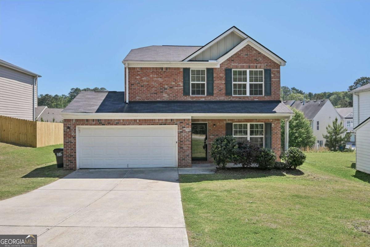
5675 Laurel Ridge Cir
East Point, GA 30344