
$1,100
/ Month
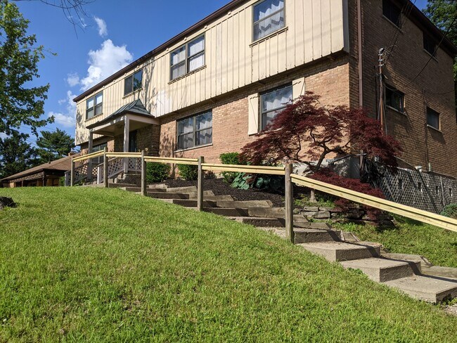
5660 Vogel Rd Unit 1
Cincinnati, OH 45239
2 Weeks Ago
Favorites
513-796-4508
-
Bedrooms
2
-
Bathrooms
1
-
Square Feet
800 sq ft
-
Available
Available Now
Highlight
- Smoke Free
5660 Vogel Rd Unit 1

Favorites
About This Home
12 Month Lease,
$1,100 deposit,
Available Now
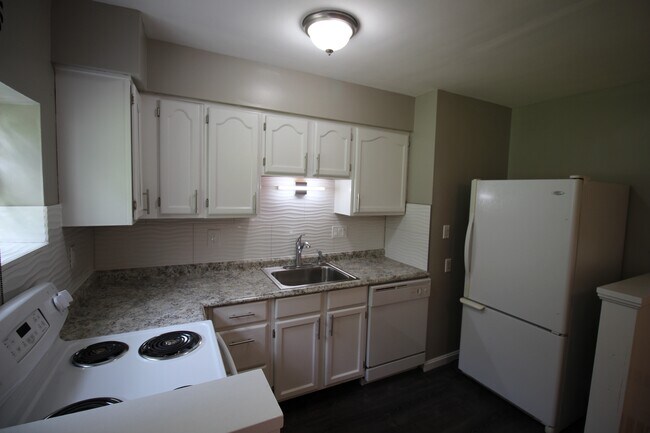
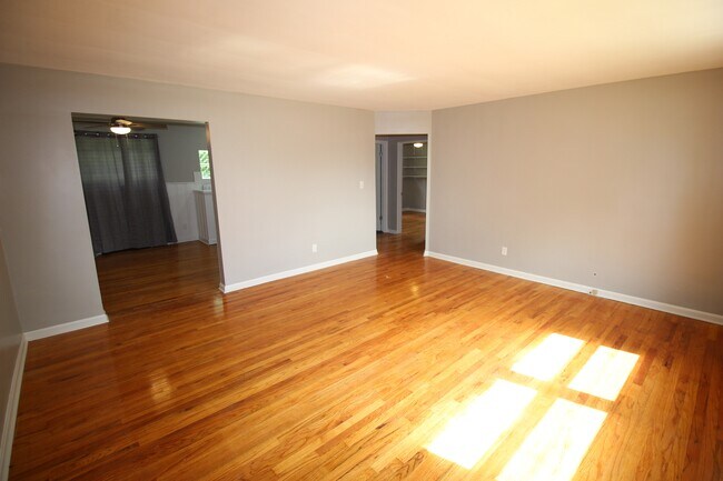
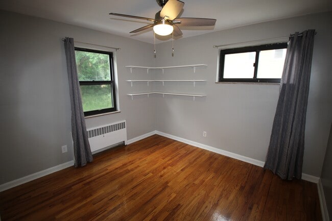
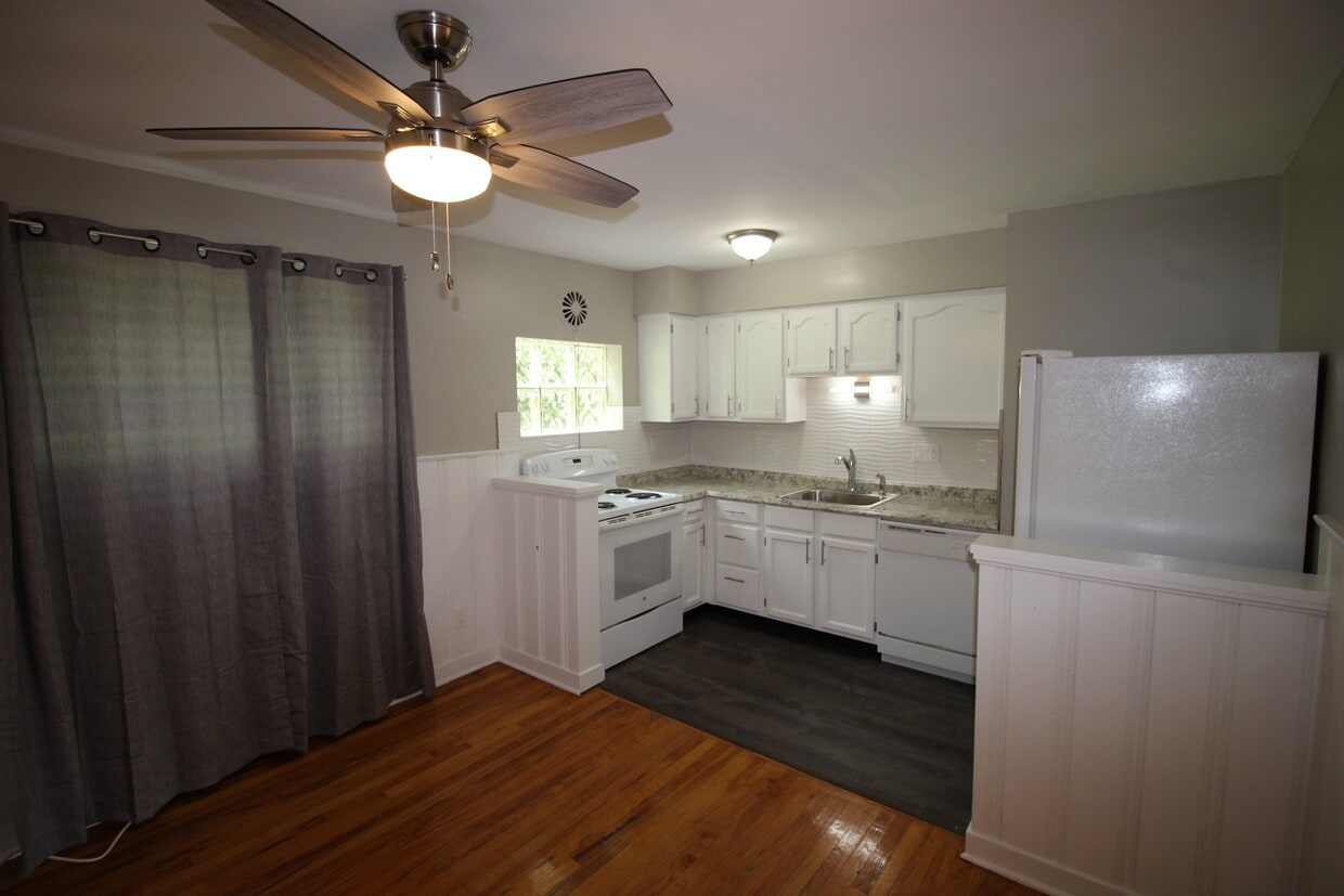
OPEN HOUSE: Saturday, Aug 23 10-11am. Charming two bedroom apartment now available for rent in a quiet neighborhood of Mt. Airy. Modern bathroom and refinished kitchen with contemporary tile and fixtures and includes dishwasher, refrigerator and stove. Oversized living room with dining area and beautiful hardwood / carpeted floors throughout. Convenient coat closet and linen closet in the hallway with additional storage available on site. This apartment has one assigned garage and one off-street parking along with a storage unit. Rent includes garbage heat and water. Convenient location close to shopping, restaurants and only 15 minutes to downtown. Bus stop a short walk away. Minimum 600 credit score and verifiable income of 3x rent. No evictions, bankruptcies or unpaid judgements. No S8. Background check will be completed.
5660 Vogel Rd is an apartment community located in Hamilton County and the 45239 ZIP Code.
* Price shown is base rent and may not include non-optional fees and utilities. Price, availability, fees, and any applicable rent special are subject to change without notice.
* Square footage definitions vary. Displayed square footage is approximate.
Apartment Features
- Air Conditioning
- Smoke Free
- Dishwasher
- Laundry Facilities
- Storage Space
Fees and Policies
The fees below are based on community-supplied data and may exclude additional fees and utilities.
- Parking
-
Garage--
Details
Utilities Included
-
Water
-
Heat
-
Trash Removal
Property Information
-
4 units
Contact
- Phone Number
- Contact
Location
Get Directions
Mount Airy is a classic suburban neighborhood with peaceful streets lined with single-family homes. Interstate 74 and Highway 22 makes the seven mile drive into Downtown Cincinnati and beyond accessible, but Mount Airy has a lot to offer from within. Its southern border encompasses Mount Airy Forest, which provides residents with outdoor fun. There are also a few fast food restaurants within the neighborhood, but residents can easily travel to the surrounding areas or into downtown for a diverse selection of restaurants. Renters will find that they have a few affordable options of apartments in longstanding brick buildings to choose from.
Learn more about living in Mount Airy
Education
| Colleges & Universities | Distance | ||
|---|---|---|---|
| Colleges & Universities | Distance | ||
| Drive: | 14 min | 5.1 mi | |
| Drive: | 14 min | 6.8 mi | |
| Drive: | 16 min | 7.2 mi | |
| Drive: | 20 min | 8.8 mi |
5660 Vogel Rd Unit 1 is within 14 minutes or 5.1 miles from Cincinnati State. It is also near University of Cincinnati and Univ. of Cincinnati, Medical.
Transportation options available in Cincinnati include Brewery District Station, Elm & Henry, located 7.5 miles from 5660 Vogel Rd Unit 1. 5660 Vogel Rd Unit 1 is near Cincinnati/Northern Kentucky International, located 21.5 miles or 39 minutes away.
| Transit / Subway | Distance | ||
|---|---|---|---|
| Transit / Subway | Distance | ||
| Drive: | 15 min | 7.5 mi | |
| Drive: | 16 min | 7.6 mi | |
| Drive: | 16 min | 7.7 mi | |
| Drive: | 16 min | 7.7 mi | |
| Drive: | 16 min | 7.8 mi |
| Commuter Rail | Distance | ||
|---|---|---|---|
| Commuter Rail | Distance | ||
|
|
Drive: | 15 min | 7.5 mi |
| Airports | Distance | ||
|---|---|---|---|
| Airports | Distance | ||
|
Cincinnati/Northern Kentucky International
|
Drive: | 39 min | 21.5 mi |
Time and distance from 5660 Vogel Rd Unit 1.
| Shopping Centers | Distance | ||
|---|---|---|---|
| Shopping Centers | Distance | ||
| Walk: | 13 min | 0.7 mi | |
| Walk: | 14 min | 0.7 mi | |
| Drive: | 3 min | 1.2 mi |
5660 Vogel Rd Unit 1 has 3 shopping centers within 1.2 miles, which is about a 3-minute walk. The miles and minutes will be for the farthest away property.
| Parks and Recreation | Distance | ||
|---|---|---|---|
| Parks and Recreation | Distance | ||
|
Mt. Airy Forest
|
Drive: | 6 min | 2.4 mi |
|
LaBoiteaux Woods
|
Drive: | 7 min | 2.9 mi |
|
Farbach-Werner Nature Preserve
|
Drive: | 7 min | 3.1 mi |
|
Buttercup Valley
|
Drive: | 8 min | 3.3 mi |
|
Caldwell Preserve
|
Drive: | 12 min | 5.6 mi |
5660 Vogel Rd Unit 1 has 5 parks within 5.6 miles, including Mt. Airy Forest, LaBoiteaux Woods, and Farbach-Werner Nature Preserve.
| Hospitals | Distance | ||
|---|---|---|---|
| Hospitals | Distance | ||
| Drive: | 7 min | 3.0 mi | |
| Drive: | 13 min | 6.1 mi | |
| Drive: | 16 min | 7.3 mi |
5660 Vogel Rd Unit 1 has 3 hospitals within 7.3 miles, the nearest is Mercy Health - West Hospital which is 3.0 miles away and a 7 minute drive.
| Military Bases | Distance | ||
|---|---|---|---|
| Military Bases | Distance | ||
| Drive: | 70 min | 54.3 mi | |
| Drive: | 76 min | 59.4 mi | |
| Drive: | 79 min | 62.6 mi |
5660 Vogel Rd Unit 1 has 3 military bases within 62.6 miles, the nearest is Gentile Air Force Station which is 54.3 miles away and a 70 minute drive.
Amenities
- Air Conditioning
- Smoke Free
- Dishwasher
- Laundry Facilities
- Storage Space
5660 Vogel Rd Unit 1 Photos
What Are Walk Score®, Transit Score®, and Bike Score® Ratings?
Walk Score® measures the walkability of any address. Transit Score® measures access to public transit. Bike Score® measures the bikeability of any address.
What is a Sound Score Rating?
A Sound Score Rating aggregates noise caused by vehicle traffic, airplane traffic and local sources
5660 Vogel Rd
Cincinnati, OH 45239