

$3,950 / Month
566 S Van Ness Ave
San Francisco, CA 94110
2 Weeks Ago
Favorites
-
Bedrooms
2
-
Bathrooms
2
-
Square Feet
963 sq ft
566 S Van Ness Ave

Favorites
About This Home
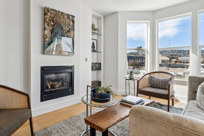
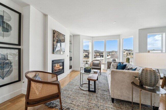
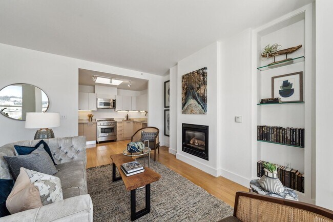
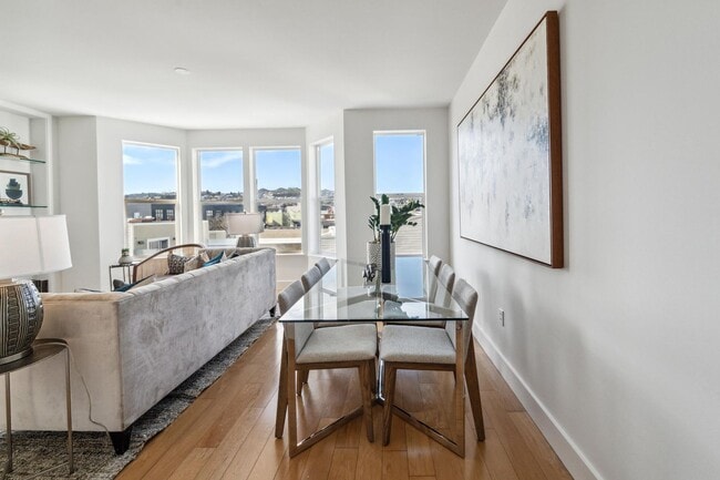
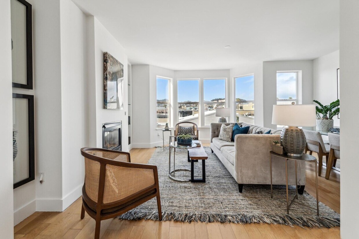
This urban boutique condo is in the PERFECT location in the Mission. One block from the hip Valencia corridor, this light filled top floor, facing rear of the building unit has it all! Modern kitchen and bath, views, wood floors, an abundance of natural daylight. PLUS rooftop deck area, landscaped courtyard, 1 car garage, storage. Open plan living room, dining room, and kitchen, all of which are light-drenched with sizable double-paned windows. Panoramic downtown SF views! The stylish kitchen features ample countertops, custom cabinetry, large sink, and stainless steel Bosch and Bertazzoni appliances, including gas stove, oven, refrigerator, built in microwave, and in unit washer and dryer. Main bedroom features on en-suite bathroom and a walk in closet. The second bedroom is also generous in size. Both bathrooms with shower over tub. Additional features of this stunning unit include: - One car garage parking - In unit laundry - Custom window coverings - Bicycle storage - Landscaped courtyard - Shared roof top deck with panoramic city views - Elevator building - Great location! Short walk to 16th Street BART. Steps from great restaurants, coffee shops, and retail stores. Easy access to Highways 101 and 280, and close to most technology bus stops Available for occupancy right away 12 month lease Rent $3,950 per month Security deposit is 1.5x one month’s rent Tenant responsible for all HOA move in and out fees Owner pays water and garbage No pets (but we do comply with all applicable rental laws) No smoking For showings, please respond via email to this ad or call or text 1-. LOCATION: 566 South Van Ness Avenue @ 17th Street CA BRE License # 01905856 Progressive Property Group, Inc.
566 S Van Ness Ave is a house located in San Francisco County and the 94110 ZIP Code. This area is served by the San Francisco Unified attendance zone.
* Price shown is base rent and may not include non-optional fees and utilities.
Price, availability, fees, and any applicable rent special are subject to change without notice.
* Square footage definitions vary. Displayed square footage is approximate.
Contact
- Listed by Progressive Property Group, Inc. | Progressive Property Group, Inc.
Location
Get Directions
Named after the historic Mission Dolores built in 1776, the Mission District is San Francisco’s oldest neighborhood. The Mission is vibrant, eclectic, and growing—well-known for its colorful murals, upscale restaurants, old-school taquerias, low-key dive bars, and craft cocktail lounges.
The Mission is home to the 16-acre Mission Dolores Park, a popular spot for enjoying the outdoors, picnicking, and taking in sweeping skyline views. A walkable design along with access to BART and Muni makes getting around from the Mission District a breeze.
Learn more about living in Mission
Education
| Colleges & Universities | Distance | ||
|---|---|---|---|
| Colleges & Universities | Distance | ||
| Drive: | 3 min | 1.2 mi | |
| Drive: | 4 min | 1.6 mi | |
| Drive: | 7 min | 2.2 mi | |
| Drive: | 8 min | 2.6 mi |
566 S Van Ness Ave is within 3 minutes or 1.2 miles from California College of the Arts. It is also near UC San Francisco, Mission Bay and Academy of Art University.
Schools


Public Elementary School
Grades K-5
Nearby
Public Elementary School
Grades K-5
357 Students
Attendance Zone
Public Middle School
Grades 6-8
938 Students
Attendance Zone
Public High School
Grades 9-12
1,041 Students
Attendance Zone
Public High School
Grades 9-12
506 Students
Attendance Zone
Private Elementary, Middle & High School
Grades K-12
84 Students
Nearby
Private Elementary & Middle School
Grades PK-8
476 Students
Nearby
Private Elementary & Middle School
Grades K-8
102 Students
Nearby
School data provided by
 The GreatSchools Rating helps parents compare schools within a state based on a variety of school quality indicators and provides a helpful picture of how effectively each school serves all of its students. Ratings are on a scale of 1 (below average) to 10 (above average) and can include test scores, college readiness, academic progress, advanced courses, equity, discipline and attendance data. We also advise parents to visit schools, consider other information on school performance and programs, and consider family needs as part of the school selection process.
View GreatSchools Rating Methodology
Data provided by GreatSchools.org © 2025. All rights reserved.
View GreatSchools Rating Methodology
Data provided by GreatSchools.org © 2025. All rights reserved.
Transportation options available in San Francisco include 16Th Street Mission Station, located 0.2 mile from 566 S Van Ness Ave. 566 S Van Ness Ave is near San Francisco International, located 12.4 miles or 21 minutes away, and Metro Oakland International, located 20.4 miles or 31 minutes away.
| Transit / Subway | Distance | ||
|---|---|---|---|
| Transit / Subway | Distance | ||
|
|
Walk: | 3 min | 0.2 mi |
|
|
Walk: | 4 min | 0.2 mi |
|
|
Walk: | 12 min | 0.6 mi |
|
|
Walk: | 13 min | 0.7 mi |
|
|
Walk: | 14 min | 0.7 mi |
| Commuter Rail | Distance | ||
|---|---|---|---|
| Commuter Rail | Distance | ||
| Drive: | 4 min | 1.9 mi | |
| Drive: | 4 min | 2.0 mi | |
| Drive: | 4 min | 2.0 mi | |
| Drive: | 4 min | 2.1 mi | |
| Drive: | 9 min | 4.6 mi |
| Airports | Distance | ||
|---|---|---|---|
| Airports | Distance | ||
|
San Francisco International
|
Drive: | 21 min | 12.4 mi |
|
Metro Oakland International
|
Drive: | 31 min | 20.4 mi |
Time and distance from 566 S Van Ness Ave.
| Shopping Centers | Distance | ||
|---|---|---|---|
| Shopping Centers | Distance | ||
| Walk: | 11 min | 0.6 mi | |
| Walk: | 18 min | 1.0 mi | |
| Walk: | 19 min | 1.0 mi |
566 S Van Ness Ave has 3 shopping centers within 1.0 miles, which is about a 19-minute walk. The miles and minutes will be for the farthest away property.
| Parks and Recreation | Distance | ||
|---|---|---|---|
| Parks and Recreation | Distance | ||
|
Buena Vista Park
|
Drive: | 5 min | 1.7 mi |
|
Randall Museum
|
Drive: | 6 min | 1.9 mi |
|
Children's Creativity Museum
|
Drive: | 4 min | 1.9 mi |
|
Conservatory of Flowers
|
Drive: | 7 min | 3.2 mi |
|
California Academy of Sciences
|
Drive: | 10 min | 4.0 mi |
566 S Van Ness Ave has 5 parks within 4.0 miles, including Randall Museum, Buena Vista Park, and Children's Creativity Museum.
| Hospitals | Distance | ||
|---|---|---|---|
| Hospitals | Distance | ||
| Drive: | 3 min | 1.2 mi | |
| Drive: | 4 min | 1.5 mi | |
| Drive: | 5 min | 1.5 mi |
566 S Van Ness Ave has 3 hospitals within 1.5 miles, the nearest is Zuckerberg San Francisco General Hospital & Trauma Center which is 1.2 miles away and a 3 minute drive.
| Military Bases | Distance | ||
|---|---|---|---|
| Military Bases | Distance | ||
| Drive: | 16 min | 6.1 mi | |
| Drive: | 14 min | 6.5 mi |
566 S Van Ness Ave is 6.1 miles from East Fort Miley, and is convenient to other military bases, including Treasure Island Naval Station.
You May Also Like
Similar Rentals Nearby


What Are Walk Score®, Transit Score®, and Bike Score® Ratings?
Walk Score® measures the walkability of any address. Transit Score® measures access to public transit. Bike Score® measures the bikeability of any address.
What is a Sound Score Rating?
A Sound Score Rating aggregates noise caused by vehicle traffic, airplane traffic and local sources
566 S Van Ness Ave
San Francisco, CA 94110