

$5,000
/ Month
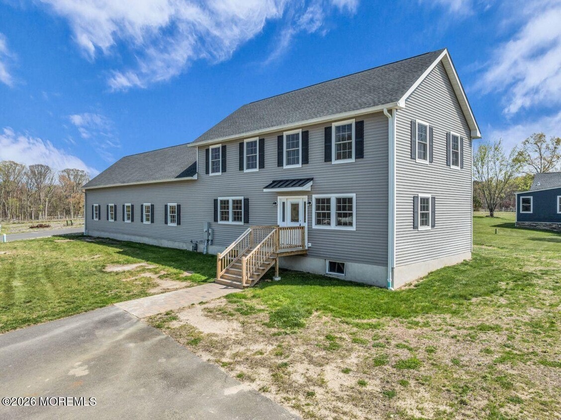
553 Colts Neck Rd
Farmingdale, NJ 07727
Favorites
732-681-4277
-
Bedrooms
4
-
Bathrooms
3
-
Square Feet
1,420 sq ft
-
Available
Available Aug 15
Highlights
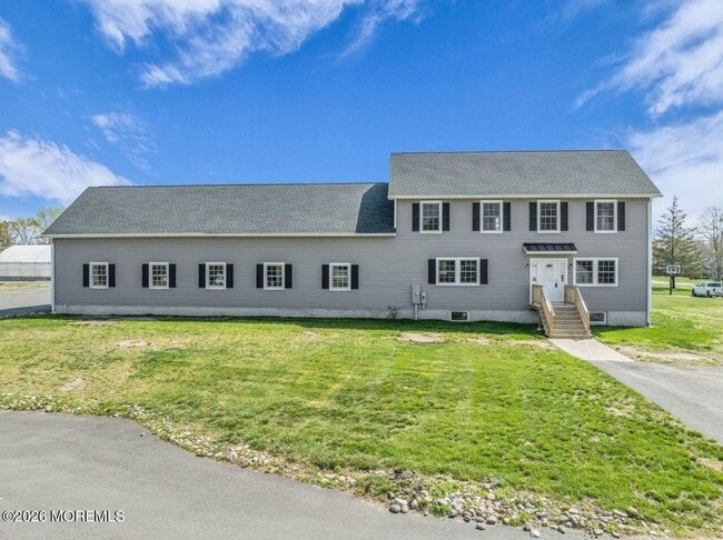
- Built in 1960 | Newly Remodeled
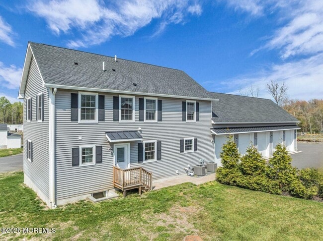
- Colonial Architecture
- Wood Flooring
- 2 Car Attached Garage
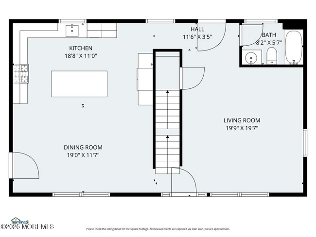
- Eat-In Kitchen
- Living Room
553 Colts Neck Rd

Favorites
About This Home
Available Aug 15
Annual Rental Available Now! Be the First to Occupy this Home recently completed and ready for You! Located on a 23 acre farm in the rural area just East of Freehold. Two Story,Four Bedroom,Three Full Baths,High Ceilings throughout. Use of two attached garages. If you are ready to make a move,See it for your self! -Prospective tenant will be required to submit an application,credit report with a score of over 700,proof of income to be considered. Shown by appointment. To Be Clear: The house is for rent,not the farm. MLS ID 22611854
553 Colts Neck Rd is a house located in Monmouth County and the 07727 ZIP Code. This area is served by the Howell Township Public School District attendance zone.
* Price shown is base rent. Excludes user-selected optional fees and variable or usage-based fees and required charges due at or prior to move-in or at move-out. Price, availability, fees, and any applicable rent special are subject to change without notice.
* Square footage definitions vary. Displayed square footage is approximate.
Home Details
Home Type
Single Family Detached Home
Year Built
Built in 1960 | Newly Remodeled
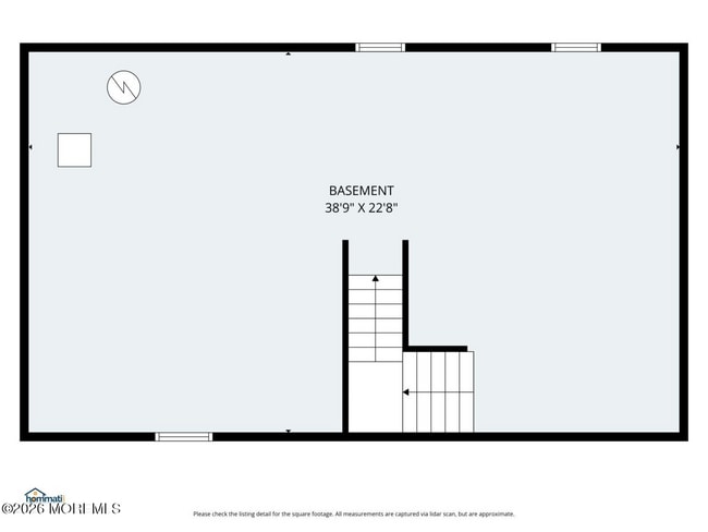
Basement
Basement Fills Entire Space Under The House
Bedrooms and Bathrooms
3 Full Bathrooms
Primary Bathroom includes a Walk-In Shower
Primary bedroom located on second floor
4 Bedrooms
Home Design
Colonial Architecture
Interior Spaces
Wood Flooring
Living Room
Recessed Lighting
Dining Room
1,420 Sq Ft Home
2-Story Property
Kitchen
Eat-In Kitchen
Gas Cooktop
Stove
Dishwasher
Laundry
Laundry Room
Dryer
Listing and Financial Details
Security Deposit $7,500
Property Available on 8/15/26
Assessor Parcel Number 21-00183-0000-00092-0000-QFARM
Lot Details
11.19 Acre Lot
Parking
2 Car Attached Garage
Off-Street Parking
Utilities
Forced Air Zoned Cooling and Heating System
Heating System Uses Natural Gas
Well
Natural Gas Water Heater
Septic Tank
Community Details
Overview
No Home Owners Association
Fees and Policies
The fees listed below are community-provided and may exclude utilities or add-ons. All payments are made directly to the property and are non-refundable unless otherwise specified.
-
Garage Lot
Property Fee Disclaimer: Based on community-supplied data and independent market research. Subject to change without notice. May exclude fees for mandatory or optional services and usage-based utilities.
Contact
- Listed by Alice A Farr-Leonard | C21/ Schlossbach Realty
- Phone Number
- Contact
-
Source
 Monmouth Ocean Regional REALTORS®
Copyright © 2026 Monmouth Ocean Regional Realtors and Monmouth Ocean Regional MLS. All rights reserved. All information provided by the listing agent/broker is deemed reliable but is not guaranteed and should be independently verified.
Location
Get Directions
Farmingdale, a borough in Monmouth County, is only 11 miles west to the closest beach. Residents can easily access Route 33 and 34, thanks to County Route 547 and 524 that pass through the town. Walking along Main Street, you’ll notice a plethora of unique stores, eateries, and banks. A handful of golf courses and parks surround Farmingdale, providing residents more options for casual fun. A few miles beyond the borough is the Monmouth Jet Center and Wall Stadium Speedway.
Learn more about living in Farmingdale
Education
| Colleges & Universities | Distance | ||
|---|---|---|---|
| Colleges & Universities | Distance | ||
| Drive: | 15 min | 8.1 mi | |
| Drive: | 15 min | 8.1 mi | |
| Drive: | 15 min | 9.4 mi | |
| Drive: | 24 min | 11.2 mi |
553 Colts Neck Rd is within 15 minutes or 8.1 miles from Brookdale C.C., Brookdale. It is also near Brookdale C.C., Freehold and Brookdale C.C., Neptune Campus.
Schools


Public Elementary & Middle School
Grades PK-8
163 Students
Nearby
Public Elementary School
Grades PK-5
404 Students
Attendance Zone
Public Elementary School
Grades K-5
334 Students
Attendance Zone
Public Middle School
Grades 6-8
970 Students
Attendance Zone
Public High School
Grades 9-12
1,775 Students
Attendance Zone
Private Elementary, Middle & High School
Grades K-12
46 Students
Nearby
Private Elementary & Middle School
Grades PK-8
Nearby
Private Elementary School
Grades PK-5
123 Students
Nearby
School data provided by
 The GreatSchools Rating helps parents compare schools within a state based on a variety of school quality indicators and provides a helpful picture of how effectively each school serves all of its students. Ratings are on a scale of 1 (below average) to 10 (above average) and can include test scores, college readiness, academic progress, advanced courses, equity, discipline and attendance data. We also advise parents to visit schools, consider other information on school performance and programs, and consider family needs as part of the school selection process.
View GreatSchools Rating Methodology
Data provided by GreatSchools.org © 2026. All rights reserved.
View GreatSchools Rating Methodology
Data provided by GreatSchools.org © 2026. All rights reserved.
Getting Around
 What do Walkability, Transit, Drivability, and Bikeability mean?
Walkability measures the walking distance to day-to-day needs.
Transit measures access to public transportation.
Drivability measures congestion, parking availability, and access to major roads.
Bikeability measures the suitability for cycling.
How It Works
What do Walkability, Transit, Drivability, and Bikeability mean?
Walkability measures the walking distance to day-to-day needs.
Transit measures access to public transportation.
Drivability measures congestion, parking availability, and access to major roads.
Bikeability measures the suitability for cycling.
How It Works
Not Walkable
Walkability
10
/ 100
Minimal Public Transit
Transit
10
/ 100
Exceptionally Drivable
Drivability
100
/ 100
Somewhat Bikeable
Bikeability
20
/ 100
Scores provided by
Calm
Soundscore™
84
/ 100
Traffic
CalmAirport
CalmBusinesses
CalmScores provided by
HowLoud What is a Sound Score Rating? A Sound Score Rating aggregates noise caused by vehicle traffic, airplane traffic and local sources. How It WorksYou May Also Like
How do I access Social Services in New Jersey?
Statewide service is free, confidential, multilingual and always open. Three easy ways to reach Social Services in NJ: Dial 2-1-1; text your zip code to 898-211; or chat at https://www.nj211.org
Similar Rentals Nearby
-
-

-
 4 Beds, 3 Baths, 2,860 sq ft$7,500Total Monthly PriceTotal Monthly Price NewPrices include all required monthly fees.208 Trenton Blvd
 -
 4 Beds, 2 Baths, 2,220 sq ft$5,000Total Monthly PriceTotal Monthly Price NewPrices include all required monthly fees.101 St Louis Ave
 -
 4 Beds, 2 Baths, 1,724 sq ft$5,000Total Monthly PriceTotal Monthly Price NewPrices include all required monthly fees.305 Baltimore Ave
 -
 6 Beds, 3 Baths, 1,965 sq ft$5,000Total Monthly PriceTotal Monthly Price NewPrices include all required monthly fees.319 Arnold Ave
 -
 4 Beds, 2 Baths, 1,620 sq ft$7,000Total Monthly PriceTotal Monthly Price NewPrices include all required monthly fees.28 Central Ave
 -
 4 Beds, 4 Baths, 2,027 sq ft$7,500Total Monthly PriceTotal Monthly Price NewPrices include all required monthly fees.416 Blodgett Ave
 -
 4 Beds, 2 Baths, 2,592 sq ft$7,500Total Monthly PriceTotal Monthly Price NewPrices include all required monthly fees.109 Washington Ave
 -
 6 Beds, 3 Baths, 2,552 sq ft$8,500Total Monthly PriceTotal Monthly Price NewPrices include all required monthly fees.50 Osborne Ave
553 Colts Neck Rd
Farmingdale, NJ 07727