

$2,600 / Month
5417 Ygnacio Ave
Oakland, CA 94601
2 Weeks Ago
Favorites
5417 Ygnacio Ave

Favorites
Check Back Soon for Upcoming Availability
| Beds | Baths | Average SF |
|---|---|---|
| 3 Bedrooms 3 Bedrooms 3 Br | 1 Bath 1 Bath 1 Ba | 900 SF |
About This Property
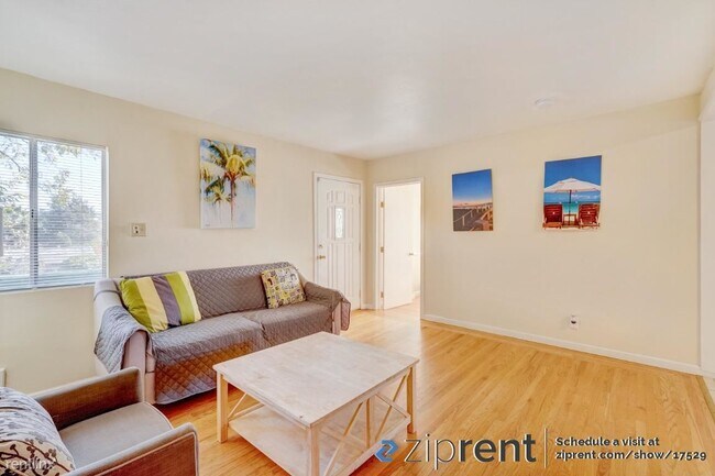
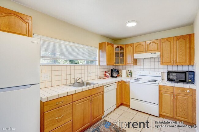
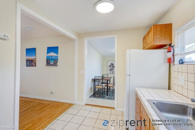
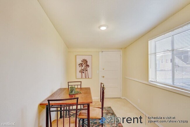
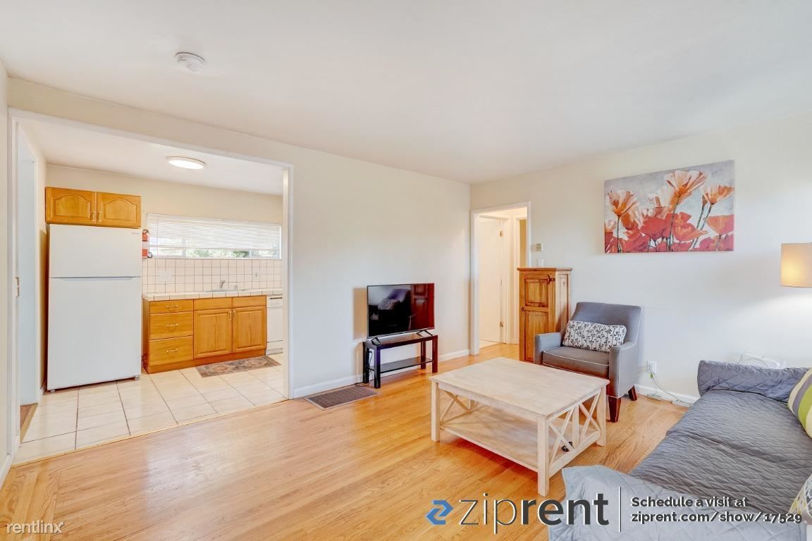
- This property is available. Please inquire on this site to schedule a showing. Must see, available now! 3 bed 1 bath upstairs unit on shared property. 1 dedicated parking space off-street. Bright and cozy features hardwood flooring and spacious bedrooms. Kitchen comes with a dishwasher, electric range, refrigerator, and microwave. Dining room off the kitchen. Balcony space, shared backyard, and shared washer/dryer onsite! Forced air heating. Backyard offers fruit trees, apples, lemons, pears, etc. The property is located in lower Maxwell Park a quiet, friendly neighborhood of small winding streets nestled in leafy Oakland Foothills above High Street and west of Mills College. Security deposit is equal to one month's rent. Water and trash are charged on $100/mo flat fee and all other utilities are the tenant's responsibility. Landscaping services are the tenant's responsibility. Sorry, no pets are allowed. Please note: Currently furnished by will remove upon request. INCOME REQUIREMENT 2.5x RENT Disclaimer: Ziprent is acting as the agent for the owner. Information Deemed Reliable but not Guaranteed. All information should be independently verified by renter. (RLNE7822044) Other Amenities: Parking (1). Lease lengths: 12 Months.
5417 Ygnacio Ave is a house located in Alameda County and the 94601 ZIP Code. This area is served by the Oakland Unified attendance zone.
Location
Get Directions
Middle East Oakland sits as a collection of neighborhoods west of Interstate 580, including Havenscourt, Lockwood Gardens, Maxwell Park, Melrose, Millsmont, Oakmore, Ridgemont, and Seminary.
The area features a variety of residential homes that have developed over 100 years. Mills College rests centrally to Middle East Oakland, with some students living within the area. Many residents choose Middle East Oakland for easy commuting access into downtown Oakland, Oracle Arena, and the Oakland International Airport.
Middle East Oakland lies six miles southeast to downtown Oakland and 15 miles east of San Francisco.
Learn more about living in Middle East OaklandBelow are rent ranges for similar nearby apartments
| Beds | Average Size | Lowest | Typical | Premium |
|---|---|---|---|---|
| Studio Studio Studio | 829-867 Sq Ft | $743 | $1,957 | $3,066 |
| 1 Bed 1 Bed 1 Bed | 565-583 Sq Ft | $1,410 | $1,789 | $2,429 |
| 2 Beds 2 Beds 2 Beds | 948-953 Sq Ft | $1,750 | $2,434 | $3,695 |
| 3 Beds 3 Beds 3 Beds | 1236 Sq Ft | $2,999 | $3,364 | $4,300 |
| 4 Beds 4 Beds 4 Beds | 1148 Sq Ft | $3,100 | $3,816 | $4,350 |
Education
| Colleges & Universities | Distance | ||
|---|---|---|---|
| Colleges & Universities | Distance | ||
| Drive: | 6 min | 1.9 mi | |
| Drive: | 8 min | 4.2 mi | |
| Drive: | 9 min | 5.6 mi | |
| Drive: | 13 min | 6.8 mi |
5417 Ygnacio Ave is within 6 minutes or 1.9 miles from Mills College. It is also near Laney College and Lincoln University, Oakland.
Schools


Public Elementary School
Grades K-5
192 Students
Attendance Zone
Public Elementary & Middle School
Grades K-8
656 Students
Nearby
Public Middle School
Grades 6-8
334 Students
Attendance Zone
Public High School
Grades 9-12
1,146 Students
Attendance Zone
Private Elementary, Middle & High School
Grades K-12
Nearby
Private Elementary, Middle & High School
Grades PK-10
Nearby
School data provided by
 The GreatSchools Rating helps parents compare schools within a state based on a variety of school quality indicators and provides a helpful picture of how effectively each school serves all of its students. Ratings are on a scale of 1 (below average) to 10 (above average) and can include test scores, college readiness, academic progress, advanced courses, equity, discipline and attendance data. We also advise parents to visit schools, consider other information on school performance and programs, and consider family needs as part of the school selection process.
View GreatSchools Rating Methodology
Data provided by GreatSchools.org © 2025. All rights reserved.
View GreatSchools Rating Methodology
Data provided by GreatSchools.org © 2025. All rights reserved.
Transportation options available in Oakland include Fruitvale Station, located 1.7 miles from 5417 Ygnacio Ave. 5417 Ygnacio Ave is near Metro Oakland International, located 6.4 miles or 11 minutes away, and San Francisco International, located 28.6 miles or 42 minutes away.
| Transit / Subway | Distance | ||
|---|---|---|---|
| Transit / Subway | Distance | ||
|
|
Drive: | 3 min | 1.7 mi |
|
|
Drive: | 5 min | 2.1 mi |
|
|
Drive: | 8 min | 5.0 mi |
|
|
Drive: | 11 min | 6.1 mi |
|
|
Drive: | 11 min | 6.7 mi |
| Commuter Rail | Distance | ||
|---|---|---|---|
| Commuter Rail | Distance | ||
|
|
Drive: | 8 min | 5.0 mi |
|
|
Drive: | 14 min | 9.6 mi |
|
|
Drive: | 17 min | 11.7 mi |
|
|
Drive: | 17 min | 11.8 mi |
| Drive: | 17 min | 11.8 mi |
| Airports | Distance | ||
|---|---|---|---|
| Airports | Distance | ||
|
Metro Oakland International
|
Drive: | 11 min | 6.4 mi |
|
San Francisco International
|
Drive: | 42 min | 28.6 mi |
Time and distance from 5417 Ygnacio Ave.
| Shopping Centers | Distance | ||
|---|---|---|---|
| Shopping Centers | Distance | ||
| Walk: | 9 min | 0.5 mi | |
| Walk: | 16 min | 0.8 mi | |
| Walk: | 19 min | 1.0 mi |
5417 Ygnacio Ave has 3 shopping centers within 1.0 miles, which is about a 19-minute walk. The miles and minutes will be for the farthest away property.
| Parks and Recreation | Distance | ||
|---|---|---|---|
| Parks and Recreation | Distance | ||
|
Leona Canyon Regional Open Space Preserve
|
Drive: | 11 min | 5.0 mi |
|
Roberts Regional Recreation Area
|
Drive: | 12 min | 5.1 mi |
|
Martin Luther King Jr. Regional Shoreline
|
Drive: | 10 min | 5.4 mi |
|
Redwood Regional Park
|
Drive: | 12 min | 5.4 mi |
|
Joaquin Miller Park
|
Drive: | 15 min | 5.9 mi |
5417 Ygnacio Ave has 5 parks within 5.9 miles, including Martin Luther King Jr. Regional Shoreline, Joaquin Miller Park, and Roberts Regional Recreation Area.
| Hospitals | Distance | ||
|---|---|---|---|
| Hospitals | Distance | ||
| Drive: | 5 min | 2.4 mi | |
| Drive: | 9 min | 3.7 mi | |
| Drive: | 8 min | 4.4 mi |
5417 Ygnacio Ave has 3 hospitals within 4.4 miles, the nearest is Telecare Heritage Psychiatric Health Facility which is 2.4 miles away and a 5 minute drive.
| Military Bases | Distance | ||
|---|---|---|---|
| Military Bases | Distance | ||
| Drive: | 17 min | 8.4 mi | |
| Drive: | 17 min | 8.6 mi |
5417 Ygnacio Ave is 8.4 miles from Alameda/US Naval Air Station Alameda, and is convenient to other military bases, including Oakland Army Base.
You May Also Like
Similar Rentals Nearby


What Are Walk Score®, Transit Score®, and Bike Score® Ratings?
Walk Score® measures the walkability of any address. Transit Score® measures access to public transit. Bike Score® measures the bikeability of any address.
What is a Sound Score Rating?
A Sound Score Rating aggregates noise caused by vehicle traffic, airplane traffic and local sources
5417 Ygnacio Ave
Oakland, CA 94601