$3,000
Total Monthly Price
5353 N Camino de la Cumbre
Tucson, AZ 85750
2 Weeks Ago
|
Edit
Favorites
5353 N Camino de la Cumbre

Favorites
Check Back Soon for Upcoming Availability
| Beds | Baths | Average SF |
|---|---|---|
| 2 Bedrooms 2 Bedrooms 2 Br | 2 Baths 2 Baths 2 Ba | 1,520 SF |
Fees and Policies
The fees listed below are community-provided and may exclude utilities or add-ons. All payments are made directly to the property and are non-refundable unless otherwise specified.
- Dogs Allowed
-
Fees not specified
- Cats Allowed
-
Fees not specified
- Parking
-
Garage--
About This Property
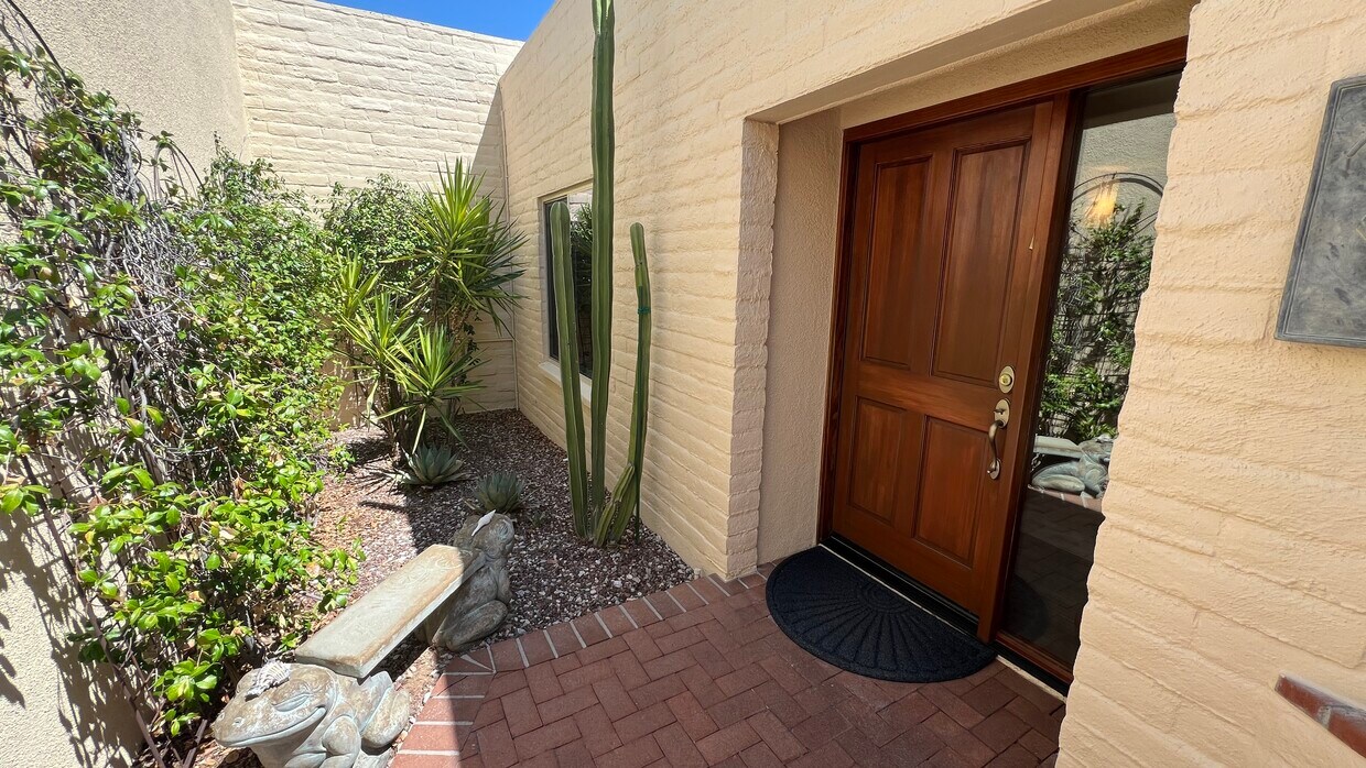
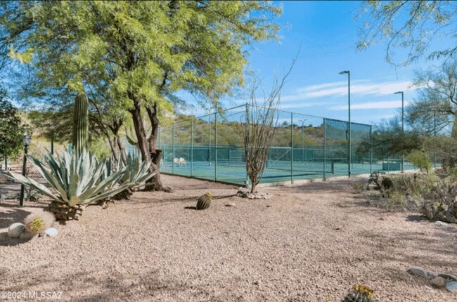
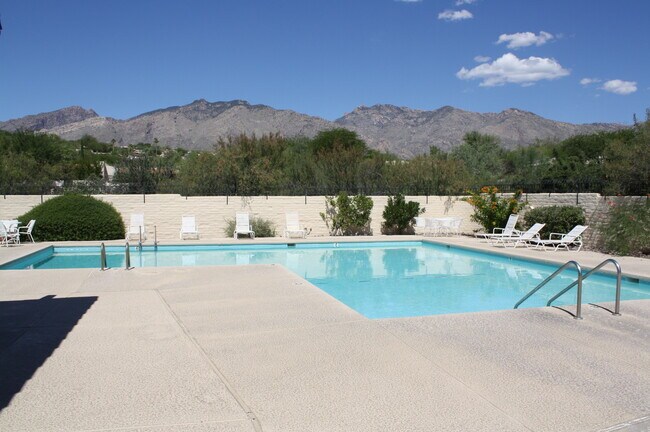
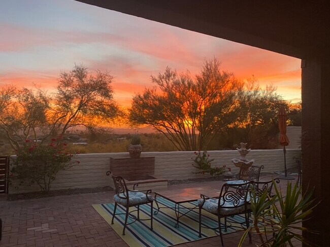
Hilltop townhome ! Views Views Views 180 degree City Lights 2 Bed, 2 Bath, 2 Car Garage with wall to wall storage cabinets 1500 + Square Feet including Bonus Room Private Back AND Side Yard Outdoor Fire Pit Granite countertops throughout Front Load Washer and dryer School District 16 Craycroft /Sunrise in the desirable Sunrise Presidio Townhomes neighborhood Community Pool and Pickleball Courts
5353 N Camino De La Cumbre is a townhome located in Pima County and the 85750 ZIP Code.
Townhome Features
Washer/Dryer
Granite Countertops
Tub/Shower
Ceiling Fans
- Washer/Dryer
- Heating
- Ceiling Fans
- Trash Compactor
- Storage Space
- Tub/Shower
- Sprinkler System
- Wheelchair Accessible (Rooms)
- Granite Countertops
- Pool
- Yard
5353 N Camino de la Cumbre,
Tucson,
AZ
85750
The Catalina Foothills is a highly sought after residential neighborhood, and it’s no secret as to why! Situated in the southern foothills of the Santa Catalina Mountains, this suburban area boasts prestigious resorts, golf courses, and spas, making it one of the more upscale communities in the state of Arizona.
With access to the Tucson Mall and various shopping centers, residents of the Catalina Foothills appreciate proximity to convenience stores, supermarkets, restaurants, retailers, art galleries, and more! For a suburban community in Tucson’s rolling hills, there are plenty of shopping, dining, and entertainment options to enjoy.
With unbeatable mountain views and desert terrain, residents and visitors alike adore local attractions like Seven Falls, a popular hiking spot in the canyon with natural wading pools and picturesque waterfalls.
Learn more about living in Catalina FoothillsBelow are rent ranges for similar nearby apartments
Amenities
- Washer/Dryer
- Heating
- Ceiling Fans
- Trash Compactor
- Storage Space
- Tub/Shower
- Sprinkler System
- Wheelchair Accessible (Rooms)
- Granite Countertops
- Yard
- Pool
Education
| Colleges & Universities | Distance | ||
|---|---|---|---|
| Colleges & Universities | Distance | ||
| Drive: | 20 min | 10.3 mi | |
| Drive: | 21 min | 11.4 mi | |
| Drive: | 23 min | 11.4 mi | |
| Drive: | 26 min | 13.0 mi |
5353 N Camino de la Cumbre is within 20 minutes or 10.3 miles from University of Arizona. It is also near Pima C.C., Downtown Campus and Pima C.C., Northwest Campus.
Transportation options available in Tucson include Sl/Helen/Warren (Se), located 10.0 miles from 5353 N Camino de la Cumbre. 5353 N Camino de la Cumbre is near Tucson International, located 17.2 miles or 30 minutes away.
| Transit / Subway | Distance | ||
|---|---|---|---|
| Transit / Subway | Distance | ||
| Drive: | 19 min | 10.0 mi | |
| Drive: | 20 min | 10.2 mi | |
| Drive: | 20 min | 10.4 mi | |
| Drive: | 21 min | 10.6 mi | |
| Drive: | 21 min | 10.9 mi |
| Commuter Rail | Distance | ||
|---|---|---|---|
| Commuter Rail | Distance | ||
|
|
Drive: | 24 min | 12.2 mi |
| Airports | Distance | ||
|---|---|---|---|
| Airports | Distance | ||
|
Tucson International
|
Drive: | 30 min | 17.2 mi |
Walkability Near 5353 N Camino de la Cumbre Tucson, AZ 85750
Getting Around
 What do Walkability, Transit, Drivability, and Bikeability mean?
Walkability measures the walking distance to day-to-day needs.
Transit measures access to public transportation.
Drivability measures congestion, parking availability, and access to major roads.
Bikeability measures the suitability for cycling.
How It Works
What do Walkability, Transit, Drivability, and Bikeability mean?
Walkability measures the walking distance to day-to-day needs.
Transit measures access to public transportation.
Drivability measures congestion, parking availability, and access to major roads.
Bikeability measures the suitability for cycling.
How It Works
Somewhat Walkable
Walkability
20
/ 100
Minimal Public Transit
Transit
0
/ 100
Exceptionally Drivable
Drivability
100
/ 100
Fairly Bikeable
Bikeability
40
/ 100
Scores provided by
-
Soundscore™
-
/ 100
Traffic
-Airport
-Businesses
-Scores provided by
HowLoud What is a Sound Score Rating? A Sound Score Rating aggregates noise caused by vehicle traffic, airplane traffic and local sources. How It WorksTime and distance from 5353 N Camino de la Cumbre.
| Shopping Centers | Distance | ||
|---|---|---|---|
| Shopping Centers | Distance | ||
| Drive: | 4 min | 1.6 mi | |
| Drive: | 4 min | 1.7 mi | |
| Drive: | 4 min | 1.7 mi |
5353 N Camino de la Cumbre has 3 shopping centers within 1.7 miles, which is about a 4-minute drive. The miles and minutes will be for the farthest away property.
| Parks and Recreation | Distance | ||
|---|---|---|---|
| Parks and Recreation | Distance | ||
|
Santa Catalina Ranger District
|
Drive: | 7 min | 3.6 mi |
|
Sabino Canyon Visitor Center
|
Drive: | 8 min | 3.7 mi |
|
Fort Lowell Park
|
Drive: | 9 min | 4.5 mi |
|
George Mehl Foothills Park
|
Drive: | 10 min | 4.8 mi |
|
Brandi Fenton Memorial Park
|
Drive: | 13 min | 5.7 mi |
5353 N Camino de la Cumbre has 5 parks within 5.7 miles, including Santa Catalina Ranger District, Fort Lowell Park, and Sabino Canyon Visitor Center.
| Hospitals | Distance | ||
|---|---|---|---|
| Hospitals | Distance | ||
| Drive: | 8 min | 4.4 mi | |
| Drive: | 9 min | 5.0 mi | |
| Drive: | 12 min | 6.6 mi |
5353 N Camino de la Cumbre has 3 hospitals within 6.6 miles, the nearest is Palo Verde Behavioral Health which is 4.4 miles away and a 8 minute drive.
| Military Bases | Distance | ||
|---|---|---|---|
| Military Bases | Distance | ||
| Drive: | 23 min | 12.7 mi | |
| Drive: | 31 min | 17.3 mi | |
| Drive: | 99 min | 80.1 mi |
5353 N Camino de la Cumbre has 3 military bases within 80.1 miles, the nearest is Davis Monthan Air Force Base which is 12.7 miles away and a 23 minute drive.
You May Also Like
Similar Rentals Nearby


What Are Walk Score®, Transit Score®, and Bike Score® Ratings?
Walk Score® measures the walkability of any address. Transit Score® measures access to public transit. Bike Score® measures the bikeability of any address.
What is a Sound Score Rating?
A Sound Score Rating aggregates noise caused by vehicle traffic, airplane traffic and local sources.

5353 N Camino de la Cumbre
Tucson, AZ 85750