

$3,295 / Month
531 29th St
Oakland, CA 94609
2 Weeks Ago
Favorites
531 29th St

Favorites
Check Back Soon for Upcoming Availability
| Beds | Baths | Average SF |
|---|---|---|
| 2 Bedrooms 2 Bedrooms 2 Br | 1.5 Baths 1.5 Baths 1.5 Ba | 1,296 SF |
Fees and Policies
The fees below are based on community-supplied data and may exclude additional fees and utilities.
- Dogs Allowed
-
Fees not specified
- Cats Allowed
-
Fees not specified
- Parking
-
Garage--
Details
Utilities Included
-
Trash Removal
About This Property
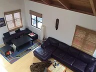
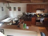
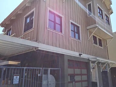
Built in 2008, this tri-level home is in between Oakland's two hottest neighborhoods - Temescal and the trendy 19th and Telegraph neighborhood. One car garage, laundry, and a large common area for entertaining make this a great spot to enjoy with friends and neighbors. HUGE Ceilings, Granite counters, and tons of light fill the home. Many green aspects of design, light-filled, beamed ceilings, Tankless H20 heater, private yard. Secured compound in the heart of Oakland revitalization, commerce and public transport. The home is in a gated area with three other homes. All appliances are updated and there is a secure, one car garage. 531 29th St is a house located in Alameda County and the 94609 ZIP Code. This area is served by the Oakland Unified attendance zone.
531 29th St is a house located in Alameda County and the 94609 ZIP Code.
House Features
Washer/Dryer
Dishwasher
Loft Layout
Smoke Free
- Washer/Dryer
- Smoke Free
- Dishwasher
- Loft Layout
- Gated
- Yard
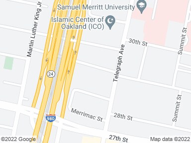
Location
Get Directions
Pill Hill is a small neighborhood located about a mile north of Downtown Oakland. Various medical facilities are located in the neighborhood, hence the name. Along with pharmacies and doctor’s offices, Pill Hill is home to the Alta Bates Summit Medical Center. Pill Hill has apartments and condos available for rent. The iconic Telegraph Avenue runs through Pill Hill so residents have access to cafes, coffee shops, and grocery stores within walking distance, but many residents take advantage of the neighborhood’s central location by traveling into neighboring communities for more shopping, dining, and entertainment options. Explore eateries on Piedmont Avenue, or head to Adams Point to access Lake Merritt. Pill Hill is nestled between Interstate 580 and 980 so it’s a great choice for anyone who wants to be able to travel across the Bay Area with ease into other major cities like Berkeley and San Francisco.
Learn more about living in Pill HillBelow are rent ranges for similar nearby apartments
Amenities
- Washer/Dryer
- Smoke Free
- Dishwasher
- Loft Layout
- Gated
- Yard
Expenses
Utilities Included
Trash Removal
Included
Education
| Colleges & Universities | Distance | ||
|---|---|---|---|
| Colleges & Universities | Distance | ||
| Walk: | 6 min | 0.3 mi | |
| Drive: | 4 min | 1.3 mi | |
| Drive: | 6 min | 2.7 mi | |
| Drive: | 8 min | 3.2 mi |
531 29th St is within 6 minutes or 0.3 mile from Samuel Merritt University. It is also near Lincoln University, Oakland and Laney College.
Transportation options available in Oakland include 19Th St Oakland Station, located 0.8 mile from 531 29th St. 531 29th St is near Metro Oakland International, located 10.4 miles or 17 minutes away, and San Francisco International, located 22.5 miles or 34 minutes away.
| Transit / Subway | Distance | ||
|---|---|---|---|
| Transit / Subway | Distance | ||
|
|
Walk: | 16 min | 0.8 mi |
|
|
Walk: | 21 min | 1.1 mi |
|
|
Drive: | 3 min | 1.1 mi |
|
|
Drive: | 2 min | 1.2 mi |
|
|
Drive: | 6 min | 3.6 mi |
| Commuter Rail | Distance | ||
|---|---|---|---|
| Commuter Rail | Distance | ||
|
|
Drive: | 5 min | 2.0 mi |
|
|
Drive: | 6 min | 3.3 mi |
|
|
Drive: | 9 min | 5.4 mi |
| Drive: | 16 min | 10.0 mi | |
| Drive: | 16 min | 10.1 mi |
| Airports | Distance | ||
|---|---|---|---|
| Airports | Distance | ||
|
Metro Oakland International
|
Drive: | 17 min | 10.4 mi |
|
San Francisco International
|
Drive: | 34 min | 22.5 mi |
Time and distance from 531 29th St.
| Shopping Centers | Distance | ||
|---|---|---|---|
| Shopping Centers | Distance | ||
| Walk: | 8 min | 0.5 mi | |
| Walk: | 16 min | 0.9 mi | |
| Drive: | 3 min | 1.2 mi |
531 29th St has 3 shopping centers within 1.2 miles, which is about a 3-minute walk. The miles and minutes will be for the farthest away property.
| Parks and Recreation | Distance | ||
|---|---|---|---|
| Parks and Recreation | Distance | ||
|
Lakeside Park Garden Center
|
Walk: | 20 min | 1.1 mi |
|
Lakeside Park
|
Drive: | 3 min | 1.3 mi |
|
Rotary Nature Center
|
Drive: | 4 min | 1.4 mi |
|
Morcom Rose Garden
|
Drive: | 5 min | 1.4 mi |
|
Juan Bautista de Anza National Historic Trail
|
Drive: | 4 min | 1.6 mi |
531 29th St has 5 parks within 1.6 miles, including Lakeside Park Garden Center, Rotary Nature Center, and Lakeside Park.
| Hospitals | Distance | ||
|---|---|---|---|
| Hospitals | Distance | ||
| Walk: | 8 min | 0.4 mi | |
| Walk: | 17 min | 0.9 mi | |
| Drive: | 3 min | 1.5 mi |
531 29th St has 3 hospitals within 1.5 miles, the nearest is Alta Bates Summit Medical Center which is 0.4 mile away and a 8 minute walk.
| Military Bases | Distance | ||
|---|---|---|---|
| Military Bases | Distance | ||
| Drive: | 12 min | 4.3 mi | |
| Drive: | 12 min | 4.7 mi |
531 29th St is 4.3 miles from Oakland Army Base, and is convenient to other military bases, including Alameda/US Naval Air Station Alameda.
You May Also Like
Similar Rentals Nearby


What Are Walk Score®, Transit Score®, and Bike Score® Ratings?
Walk Score® measures the walkability of any address. Transit Score® measures access to public transit. Bike Score® measures the bikeability of any address.
What is a Sound Score Rating?
A Sound Score Rating aggregates noise caused by vehicle traffic, airplane traffic and local sources
531 29th St
Oakland, CA 94609