
$2,000
/ Month
52 Boyd St
Newark, NJ 07103
Favorites
52 Boyd St

Favorites
Check Back Soon for Upcoming Availability
| Beds | Baths | Average SF |
|---|---|---|
| 2 Bedrooms 2 Bedrooms 2 Br | 1 Bath 1 Bath 1 Ba | 1,400 SF |
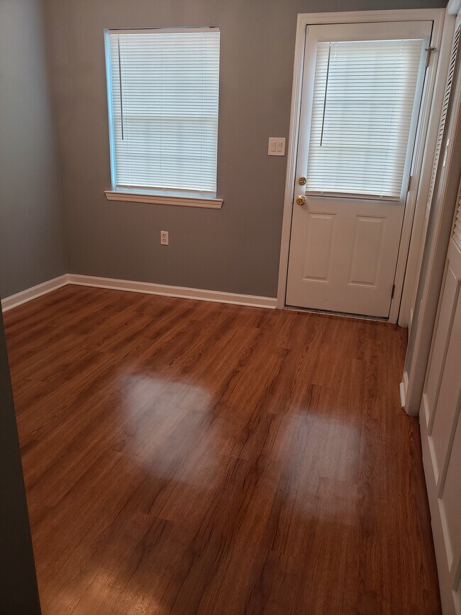
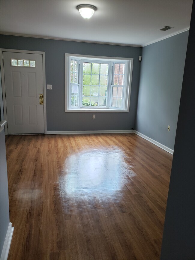
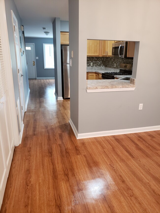
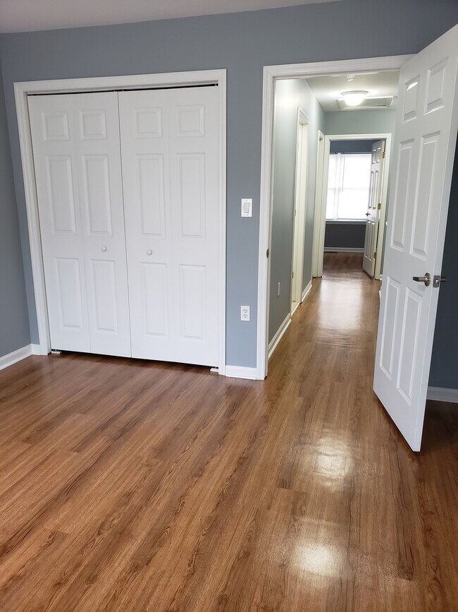
About This Property
Newly renovated 2 bedroom quite gated Community with 24 hours security. Nearby 3 major highways, access to public transportation and 5 minutes to Newark Penstation
52 Boyd St is a townhome located in Essex County and the 07103 ZIP Code. This area is served by the The Newark Public School District attendance zone.
Townhome Features
- Washer/Dryer
- Washer/Dryer Hookup
- Dishwasher
52 Boyd St,
Newark,
NJ
07103
Springfield-Belmont is an urban neighborhood in the heart of Newark. Filled with community parks like Jesse Allen Park and Nat Turner Park, the area is very family friendly. Springfield-Belmont sits just south of Rutgers University Newark Campus in University Heights. Residents of this convenient area have easy access to everything Downtown Newark has to offer, including the Prudential Center, the New Jersey Performing Arts Center, and University Hospital. Locals can easily travel to New York City as well, making this an ideal neighborhood for students and commuters.
Learn more about living in Springfield-BelmontBelow are rent ranges for similar nearby apartments
Amenities
- Washer/Dryer
- Washer/Dryer Hookup
- Dishwasher
Education
| Colleges & Universities | Distance | ||
|---|---|---|---|
| Colleges & Universities | Distance | ||
| Drive: | 2 min | 1.2 mi | |
| Drive: | 3 min | 1.4 mi | |
| Drive: | 3 min | 1.7 mi | |
| Drive: | 9 min | 4.0 mi |
52 Boyd St is within 2 minutes or 1.2 miles from Essex County College. It is also near N.J. Inst. of Technology and Rutgers, Newark Campus.
Schools

Public Elementary & Middle School
Grades PK-8
341 Students
Nearby
Public High School
Grades 9-12
Nearby
Private Elementary & Middle School
Grades PK-8
Nearby
Private Elementary & Middle School
Grades K-8
Nearby
Private Middle & High School
Grades 6-12
Nearby
School data provided by
 The GreatSchools Rating helps parents compare schools within a state based on a variety of school quality indicators and provides a helpful picture of how effectively each school serves all of its students. Ratings are on a scale of 1 (below average) to 10 (above average) and can include test scores, college readiness, academic progress, advanced courses, equity, discipline and attendance data. We also advise parents to visit schools, consider other information on school performance and programs, and consider family needs as part of the school selection process.
View GreatSchools Rating Methodology
Data provided by GreatSchools.org © 2026. All rights reserved.
View GreatSchools Rating Methodology
Data provided by GreatSchools.org © 2026. All rights reserved.
Transportation options available in Newark include Warren Street, located 1.2 miles from 52 Boyd St. 52 Boyd St is near Newark Liberty International, located 5.3 miles or 9 minutes away, and LaGuardia, located 24.6 miles or 43 minutes away.
| Transit / Subway | Distance | ||
|---|---|---|---|
| Transit / Subway | Distance | ||
|
|
Drive: | 3 min | 1.2 mi |
|
|
Drive: | 3 min | 1.3 mi |
|
|
Drive: | 2 min | 1.3 mi |
|
|
Drive: | 3 min | 1.4 mi |
|
|
Drive: | 4 min | 1.7 mi |
| Commuter Rail | Distance | ||
|---|---|---|---|
| Commuter Rail | Distance | ||
|
|
Drive: | 3 min | 1.7 mi |
|
|
Drive: | 4 min | 2.0 mi |
|
|
Drive: | 6 min | 2.7 mi |
|
|
Drive: | 9 min | 3.7 mi |
|
|
Drive: | 9 min | 3.7 mi |
| Airports | Distance | ||
|---|---|---|---|
| Airports | Distance | ||
|
Newark Liberty International
|
Drive: | 9 min | 5.3 mi |
|
LaGuardia
|
Drive: | 43 min | 24.6 mi |
Walkability Near 52 Boyd St Newark, NJ 07103
Getting Around
 What do Walkability, Transit, Drivability, and Bikeability mean?
Walkability measures the walking distance to day-to-day needs.
Transit measures access to public transportation.
Drivability measures congestion, parking availability, and access to major roads.
Bikeability measures the suitability for cycling.
How It Works
What do Walkability, Transit, Drivability, and Bikeability mean?
Walkability measures the walking distance to day-to-day needs.
Transit measures access to public transportation.
Drivability measures congestion, parking availability, and access to major roads.
Bikeability measures the suitability for cycling.
How It Works
Very Walkable
Walkability
80
/ 100
Exceptional Public Transit
Transit
90
/ 100
Moderately Drivable
Drivability
60
/ 100
Fairly Bikeable
Bikeability
50
/ 100
Scores provided by
-
Soundscore™
-
/ 100
Traffic
-Airport
-Businesses
-Scores provided by
HowLoud What is a Sound Score Rating? A Sound Score Rating aggregates noise caused by vehicle traffic, airplane traffic and local sources. How It WorksTime and distance from 52 Boyd St.
| Shopping Centers | Distance | ||
|---|---|---|---|
| Shopping Centers | Distance | ||
| Walk: | 11 min | 0.6 mi | |
| Walk: | 14 min | 0.7 mi | |
| Walk: | 15 min | 0.8 mi |
52 Boyd St has 3 shopping centers within 0.8 mile, which is about a 15-minute walk. The miles and minutes will be for the farthest away property.
| Parks and Recreation | Distance | ||
|---|---|---|---|
| Parks and Recreation | Distance | ||
|
Newark Museum and Dreyfuss Planetarium
|
Drive: | 3 min | 1.6 mi |
|
Branch Brook Park
|
Drive: | 7 min | 3.1 mi |
|
Kearny Marsh
|
Drive: | 10 min | 4.6 mi |
|
Edison National Historic Site
|
Drive: | 11 min | 5.6 mi |
|
Richard W. DeKorte Park
|
Drive: | 15 min | 7.4 mi |
52 Boyd St has 5 parks within 7.4 miles, including Newark Museum and Dreyfuss Planetarium, Branch Brook Park, and Kearny Marsh.
| Hospitals | Distance | ||
|---|---|---|---|
| Hospitals | Distance | ||
| Walk: | 19 min | 1.0 mi | |
| Drive: | 3 min | 1.7 mi | |
| Drive: | 5 min | 2.6 mi |
52 Boyd St has 3 hospitals within 2.6 miles, the nearest is The University Hospital which is 1.0 miles away and a 19 minute walk.
| Military Bases | Distance | ||
|---|---|---|---|
| Military Bases | Distance | ||
| Drive: | 14 min | 9.1 mi | |
| Drive: | 27 min | 16.7 mi | |
| Drive: | 30 min | 17.3 mi |
52 Boyd St has 3 military bases within 17.3 miles, the nearest is Military Ocean Terminal which is 9.1 miles away and a 14 minute drive.
You May Also Like
How do I access Social Services in New Jersey?
Statewide service is free, confidential, multilingual and always open. Three easy ways to reach Social Services in NJ: Dial 2-1-1; text your zip code to 898-211; or chat at https://www.nj211.org
Similar Rentals Nearby


What Are Walk Score®, Transit Score®, and Bike Score® Ratings?
Walk Score® measures the walkability of any address. Transit Score® measures access to public transit. Bike Score® measures the bikeability of any address.
What is a Sound Score Rating?
A Sound Score Rating aggregates noise caused by vehicle traffic, airplane traffic and local sources.
52 Boyd St
Newark, NJ 07103