
$1,875
/ Month
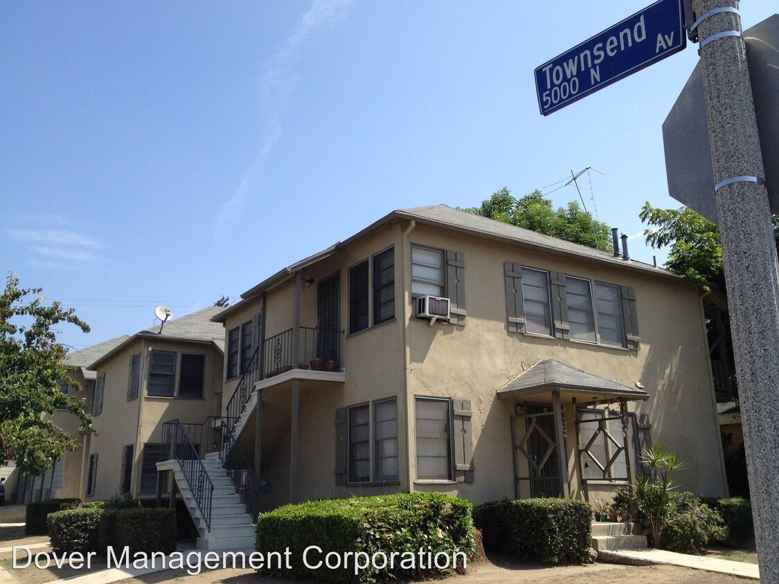
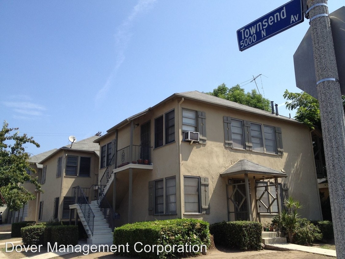
5056 Townsend Ave
Los Angeles, CA 90041
2 Weeks Ago
|
Edit
Favorites
5056 Townsend Ave

Favorites
Check Back Soon for Upcoming Availability
| Beds | Baths | Average SF |
|---|---|---|
| 2 Bedrooms 2 Bedrooms 2 Br | 1 Bath 1 Bath 1 Ba | — |
About This Property
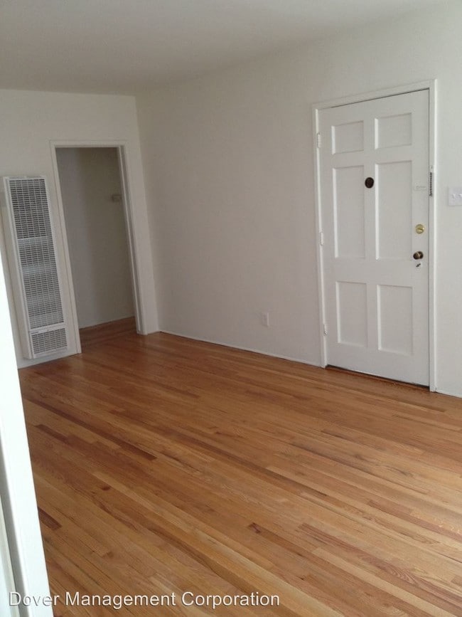
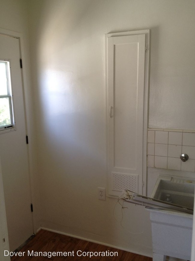
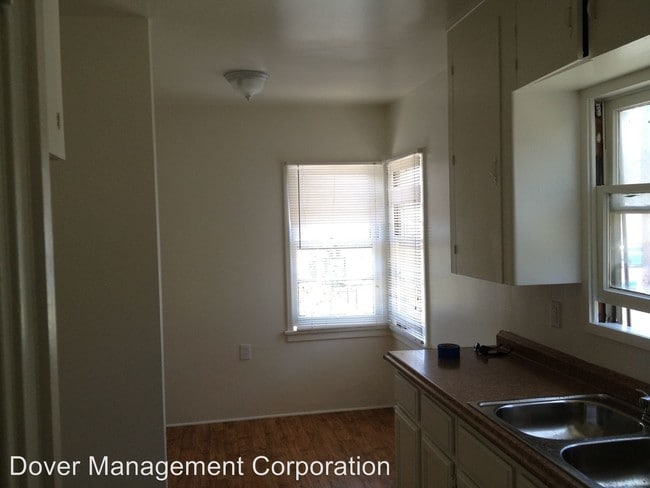
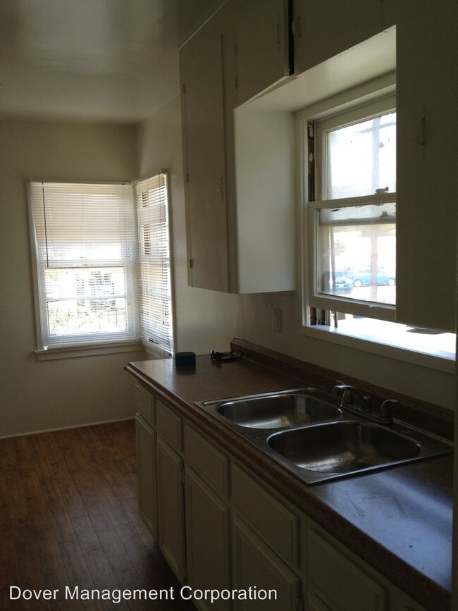
(818) 843-5200 - COMPLETELY REMODELED SPACIOUS 2B+1B in the HEART OF EAGLE ROCK - Email: jtsai@dovermgt.com or call (818) 843-5200 ext 214 to set up showing 1. Refinished hardwood floors 2. reglazed sink and tub 3. new kitchen and kitchen and bathroom flooring 4. New wall heater unit 5. Ceiling fans in every bedroom 6. 2nd Floor unit with beautiful views 7. Dedicated garage for parking and/or storage 8. Plenty of built in storage. 9. Freshly painted and ready for MOVE IN!!! 10. Located in the heart of Eagle Rock across the street from the famous Public House bar and restaurant. Also located near Eagle Rock Pub, Casa Blanca Pizza Pie, Pete's Burgers, Tommy's Burgers, Oinkster, Colombo's Italian Steakhouse, Trader Joe's, Cold Pressed Juice, Target, etc. 11. Close to 2 and 134 FWY. Sorry no pets. One minutes walk to Eagle Rock Coin Laundry 1578 Colorado Blvd (323) 257-8228 (RLNE2483730)
5056 Townsend Ave is a condo located in Los Angeles County and the 90041 ZIP Code. This area is served by the Los Angeles Unified attendance zone.
Location
Get Directions
A large sector of the city, Northeast Los Angeles encompasses neighborhoods like Echo Park and Highland Park. This expansive LA area offers rentals for every type of renter and every budget. Abundant apartments, houses, condos, and townhomes can be found in Northeast Los Angeles, ranging from affordable to upscale. Residents of this area can enjoy the great outdoors at locales like Ernest E. Debs Regional Park, Hermon Park, Rio De Los Angeles State Park, and Elysian Park. Although Northeast LA offers an escape from big-city living, residents can easily travel into downtown for work or leisure. Amenities and attractions like Dodger Stadium, Los Angeles State Historic Park, and Chinatown are all within reach of this sprawling district.
Learn more about living in Northeast Los AngelesBelow are rent ranges for similar nearby apartments
Education
| Colleges & Universities | Distance | ||
|---|---|---|---|
| Colleges & Universities | Distance | ||
| Drive: | 5 min | 2.0 mi | |
| Drive: | 7 min | 3.8 mi | |
| Drive: | 8 min | 4.7 mi | |
| Drive: | 10 min | 4.7 mi |
5056 Townsend Ave is within 5 minutes or 2.0 miles from Occidental College. It is also near Glendale Community College and Art Center College of Design.
Schools


Public Elementary School
Grades K-6
376 Students
Attendance Zone
Public Elementary School
Grades K-6
756 Students
Nearby
Public Middle & High School
Grades 7-12
2,069 Students
Attendance Zone
Private Elementary School
Grades 1-6
Nearby
Private Elementary & Middle School
Grades K-8
Nearby
Private Elementary, Middle & High School
Grades PK-12
27 Students
Nearby
Private Middle & High School
Grades 6-12
Nearby
School data provided by
 The GreatSchools Rating helps parents compare schools within a state based on a variety of school quality indicators and provides a helpful picture of how effectively each school serves all of its students. Ratings are on a scale of 1 (below average) to 10 (above average) and can include test scores, college readiness, academic progress, advanced courses, equity, discipline and attendance data. We also advise parents to visit schools, consider other information on school performance and programs, and consider family needs as part of the school selection process.
View GreatSchools Rating Methodology
Data provided by GreatSchools.org © 2025. All rights reserved.
View GreatSchools Rating Methodology
Data provided by GreatSchools.org © 2025. All rights reserved.
Transportation options available in Los Angeles include Highland Park Station, located 3.0 miles from 5056 Townsend Ave. 5056 Townsend Ave is near Bob Hope, located 13.3 miles or 19 minutes away, and Los Angeles International, located 23.6 miles or 37 minutes away.
| Transit / Subway | Distance | ||
|---|---|---|---|
| Transit / Subway | Distance | ||
|
|
Drive: | 6 min | 3.0 mi |
|
|
Drive: | 8 min | 3.3 mi |
|
|
Drive: | 6 min | 3.5 mi |
|
|
Drive: | 8 min | 4.1 mi |
|
|
Drive: | 7 min | 4.2 mi |
| Commuter Rail | Distance | ||
|---|---|---|---|
| Commuter Rail | Distance | ||
|
|
Drive: | 9 min | 5.4 mi |
|
|
Drive: | 12 min | 7.9 mi |
|
|
Drive: | 15 min | 8.5 mi |
|
|
Drive: | 17 min | 9.3 mi |
| Drive: | 19 min | 13.6 mi |
| Airports | Distance | ||
|---|---|---|---|
| Airports | Distance | ||
|
Bob Hope
|
Drive: | 19 min | 13.3 mi |
|
Los Angeles International
|
Drive: | 37 min | 23.6 mi |
Time and distance from 5056 Townsend Ave.
| Shopping Centers | Distance | ||
|---|---|---|---|
| Shopping Centers | Distance | ||
| Walk: | 2 min | 0.1 mi | |
| Walk: | 5 min | 0.3 mi | |
| Walk: | 17 min | 0.9 mi |
5056 Townsend Ave has 3 shopping centers within 0.9 mile, which is about a 17-minute walk. The miles and minutes will be for the farthest away property.
| Parks and Recreation | Distance | ||
|---|---|---|---|
| Parks and Recreation | Distance | ||
|
Kidspace Children's Museum
|
Drive: | 6 min | 3.3 mi |
|
Audubon Center at Debs Park
|
Drive: | 9 min | 3.7 mi |
|
Elyria Canyon Park
|
Drive: | 9 min | 4.3 mi |
|
Marsh Park
|
Drive: | 10 min | 5.6 mi |
|
Jet Propulsion Laboratory
|
Drive: | 9 min | 5.9 mi |
5056 Townsend Ave has 5 parks within 5.9 miles, including Kidspace Children's Museum, Audubon Center at Debs Park, and Elyria Canyon Park.
| Hospitals | Distance | ||
|---|---|---|---|
| Hospitals | Distance | ||
| Drive: | 5 min | 2.4 mi | |
| Drive: | 6 min | 4.0 mi | |
| Drive: | 8 min | 4.3 mi |
5056 Townsend Ave has 3 hospitals within 4.3 miles, the nearest is Glendale Adventist Medical Center which is 2.4 miles away and a 5 minute drive.
| Military Bases | Distance | ||
|---|---|---|---|
| Military Bases | Distance | ||
| Drive: | 35 min | 25.2 mi | |
| Drive: | 47 min | 33.6 mi |
5056 Townsend Ave is 25.2 miles from Los Angeles Air Force Base, and is convenient to other military bases, including Los Alamitos Army Airfield.
You May Also Like
Similar Rentals Nearby
-
-

-

-

-

-
1 / 11

-
1 / 21

-
1 / 17

-
1 / 26

-
1 / 20

What Are Walk Score®, Transit Score®, and Bike Score® Ratings?
Walk Score® measures the walkability of any address. Transit Score® measures access to public transit. Bike Score® measures the bikeability of any address.
What is a Sound Score Rating?
A Sound Score Rating aggregates noise caused by vehicle traffic, airplane traffic and local sources
5056 Townsend Ave
Los Angeles, CA 90041