
Presidential Towers
555 W Madison St,
Chicago, IL 60661
$1,800 - $5,018
Studio - 2 Beds

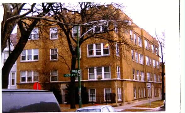
Discover your new place at 4901 N Seeley Ave in Chicago, IL. You'll find this community in the Ravenswood area of Chicago. Compare 1 to 2 bedroom apartments. The professional leasing team will assist you in finding the best floor plan for your lifestyle. Drop by the leasing office to schedule a tour and find your new home at 4901 N Seeley Ave.
4901 N Seeley Ave is an apartment community located in Cook County and the 60625 ZIP Code. This area is served by the Chicago Public Schools attendance zone.
High Speed Internet Access
Smoke Free
Heating
Kitchen
Ravenswood is a historic gem just 10 miles northwest of downtown Chicago. This neighborhood is family-friendly with extensive public transportation and easy access to major highways. People walk the neighborhood and also bike from place to place. You’ll want to visit Ravenswood’s Historic District where you’ll find 100-year old houses and Victorian mansions. In an old school space, you can watch popular films in this neighborhood staple, the Davis Theater.
Funky, hip, and chic restaurants, bars, and coffee shops reside in Ravenswood like Band of Bohemia on North Ravenswood Avenue. There’s a mix of public, private, and charter schools in the area that give residents a multitude of choices for their children. Community festivals are long-standing tradition in Ravenswood. The Ravenswood Art Walk occurs every September, and the Annual Taste of Ravenswood is an annual affair that celebrates its local eateries and craft beers.
Learn more about living in RavenswoodCompare neighborhood and city base rent averages by bedroom.
| Ravenswood | Chicago, IL | |
|---|---|---|
| Studio | $1,239 | $1,632 |
| 1 Bedroom | $1,525 | $2,023 |
| 2 Bedrooms | $2,298 | $2,543 |
| 3 Bedrooms | $3,136 | $3,064 |
| Colleges & Universities | Distance | ||
|---|---|---|---|
| Colleges & Universities | Distance | ||
| Drive: | 3 min | 1.5 mi | |
| Drive: | 5 min | 2.2 mi | |
| Drive: | 6 min | 2.9 mi | |
| Drive: | 7 min | 3.1 mi |


Transportation options available in Chicago include Damen Station (Brown Line), located 0.4 mile from 4901 N Seeley Ave. 4901 N Seeley Ave is near Chicago O'Hare International, located 12.5 miles or 21 minutes away, and Chicago Midway International, located 17.1 miles or 28 minutes away.
| Transit / Subway | Distance | ||
|---|---|---|---|
| Transit / Subway | Distance | ||
|
|
Walk: | 6 min | 0.4 mi |
|
|
Walk: | 14 min | 0.7 mi |
|
|
Walk: | 16 min | 0.9 mi |
|
|
Drive: | 4 min | 1.5 mi |
|
|
Drive: | 4 min | 1.7 mi |
| Commuter Rail | Distance | ||
|---|---|---|---|
| Commuter Rail | Distance | ||
|
|
Walk: | 9 min | 0.5 mi |
| Drive: | 4 min | 1.7 mi | |
|
|
Drive: | 8 min | 3.3 mi |
|
|
Drive: | 7 min | 4.0 mi |
|
|
Drive: | 9 min | 5.0 mi |
| Airports | Distance | ||
|---|---|---|---|
| Airports | Distance | ||
|
Chicago O'Hare International
|
Drive: | 21 min | 12.5 mi |
|
Chicago Midway International
|
Drive: | 28 min | 17.1 mi |
Scores provided by
Traffic
-Airport
-Businesses
-Scores provided by
HowLoud What is a Sound Score Rating? A Sound Score Rating aggregates noise caused by vehicle traffic, airplane traffic and local sources. How It WorksTime and distance from 4901 N Seeley Ave.
| Shopping Centers | Distance | ||
|---|---|---|---|
| Shopping Centers | Distance | ||
| Walk: | 9 min | 0.5 mi | |
| Walk: | 9 min | 0.5 mi | |
| Walk: | 13 min | 0.7 mi |
| Parks and Recreation | Distance | ||
|---|---|---|---|
| Parks and Recreation | Distance | ||
|
Winnemac Park
|
Walk: | 10 min | 0.5 mi |
|
Chase Park
|
Walk: | 16 min | 0.9 mi |
|
Warren Park
|
Drive: | 6 min | 2.8 mi |
|
Gompers Park
|
Drive: | 7 min | 3.5 mi |
|
North Park Village Nature Center
|
Drive: | 7 min | 3.6 mi |
| Hospitals | Distance | ||
|---|---|---|---|
| Hospitals | Distance | ||
| Walk: | 12 min | 0.7 mi | |
| Drive: | 3 min | 1.5 mi | |
| Drive: | 4 min | 1.8 mi |
| Military Bases | Distance | ||
|---|---|---|---|
| Military Bases | Distance | ||
| Drive: | 30 min | 20.2 mi |
What Are Walk Score®, Transit Score®, and Bike Score® Ratings?
Walk Score® measures the walkability of any address. Transit Score® measures access to public transit. Bike Score® measures the bikeability of any address.
What is a Sound Score Rating?
A Sound Score Rating aggregates noise caused by vehicle traffic, airplane traffic and local sources.
4901 N Seeley Ave
Chicago, IL 60625


