

$3,000
/ Month
49 Larch St
Carteret, NJ 07008
Favorites
732-969-5600
-
Bedrooms
3
-
Bathrooms
2.5
-
Square Feet
--
-
Available
Available Now
49 Larch St

Favorites
About This Home
12 Month Lease
,
Available Now
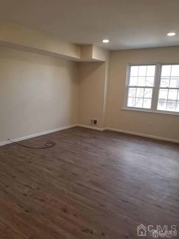
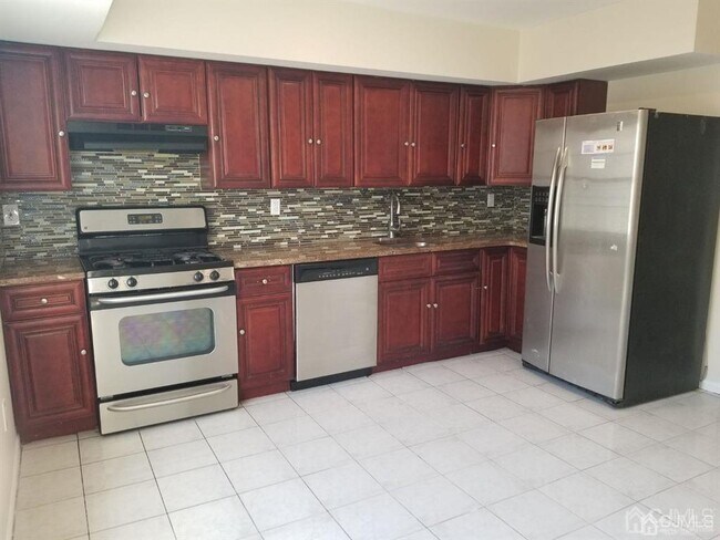
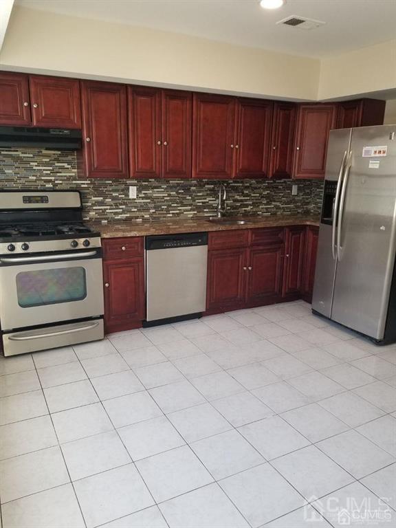
This townhouse is ready to move in. Features 3 levels first level family room,1 bedroom and full bathroom,second level living room,kitchen with granite counter tops and plenty of cabinets space,1/2 bathroom and laundry hook ups. Third level features 2 bedrooms with plenty of closet space and extra closet on the hallway and 1 full bathroom,force air heat and central air conditioner. Tenants are responsible for all utilities and maintenance of the yard and snow removal.
49 Larch St is a townhome located in Middlesex County and the 07008 ZIP Code. This area is served by the Carteret Public School District attendance zone.
* Price shown is base rent. Excludes user-selected optional fees and variable or usage-based fees and required charges due at or prior to move-in or at move-out. Price, availability, fees, and any applicable rent special are subject to change without notice.
* Square footage definitions vary. Displayed square footage is approximate.
Townhome Features
Air Conditioning
Dishwasher
Refrigerator
Tile Floors
- Air Conditioning
- Dishwasher
- Kitchen
- Oven
- Range
- Refrigerator
- Tile Floors
- Vinyl Flooring
- Dining Room
- Family Room
Contact
- Listed by NATALIA OCHS | MJ HOMES REALTY,LLC.
- Phone Number
- Contact
-
Source
 CENTRAL JERSEY MULTIPLE LISTING SYSTEM, INC
The CENTRAL JERSEY MULTIPLE LISTING SYSTEM, INC does not warrant the accuracy, quality, reliability, suitability, completeness, usefulness or effectiveness of any information provided. The information being provided is for consumers' personal, non-commercial use and may not be used for any purpose other than to identify properties the consumer may be interested in purchasing or renting. Copyright 2026, CENTRAL JERSEY MULTIPLE LISTING SYSTEM, INC. All rights reserved. “The CENTRAL JERSEY MULTIPLE LISTING SYSTEM, INC retains all rights, title and interest in and to its trademarks, service marks and copyrighted material.
Location
Get Directions
Carteret, a borough in northeastern Middlesex County, sits along the Arthur Kill waterway and bills itself as the "Center of it All," a nod to its central location just 22 miles from Manhattan and 10 miles from Newark. Named after Sir George Carteret, one of the earliest proprietors of the province of New Jersey, the borough has a rich history dating back to its founding in 1906. Renters looking at apartments for rent in Carteret will find a well-connected community with easy access to major employment hubs, green spaces, and everyday conveniences all within a compact five-square-mile area.
Renters in Carteret can choose from a mix of apartments, condos, townhomes, and houses spread across established residential neighborhoods. Washington Avenue features brick-paved sidewalks and locally-owned shops and cafes, while Roosevelt Avenue offers a more contemporary mix of dining and retail.
Learn more about living in Carteret
Amenities
- Air Conditioning
- Dishwasher
- Kitchen
- Oven
- Range
- Refrigerator
- Tile Floors
- Vinyl Flooring
- Dining Room
- Family Room
Education
| Colleges & Universities | Distance | ||
|---|---|---|---|
| Colleges & Universities | Distance | ||
| Drive: | 16 min | 8.4 mi | |
| Drive: | 19 min | 10.1 mi | |
| Drive: | 21 min | 11.3 mi | |
| Drive: | 25 min | 14.3 mi |
49 Larch St is within 16 minutes or 8.4 miles from Union County Coll., Elizabeth. It is also near Kean University and Coll. of Staten Island, CUNY.
Schools


Public Elementary School
Grades PK-5
578 Students
Attendance Zone
Public Elementary School
Grades K-5
553 Students
Attendance Zone
Public Middle School
Grades 6-8
607 Students
Nearby
Public High School
Grades 9-12
1,089 Students
Attendance Zone
Private Elementary, Middle & High School
Grades K-12
40 Students
Nearby
Private Elementary School
Grades PK-5
Nearby
School data provided by
 The GreatSchools Rating helps parents compare schools within a state based on a variety of school quality indicators and provides a helpful picture of how effectively each school serves all of its students. Ratings are on a scale of 1 (below average) to 10 (above average) and can include test scores, college readiness, academic progress, advanced courses, equity, discipline and attendance data. We also advise parents to visit schools, consider other information on school performance and programs, and consider family needs as part of the school selection process.
View GreatSchools Rating Methodology
Data provided by GreatSchools.org © 2026. All rights reserved.
View GreatSchools Rating Methodology
Data provided by GreatSchools.org © 2026. All rights reserved.
Transportation options available in Carteret include 8Th Street Light Rail Station, located 12.9 miles from 49 Larch St. 49 Larch St is near Newark Liberty International, located 14.5 miles or 24 minutes away, and LaGuardia, located 31.9 miles or 53 minutes away.
| Transit / Subway | Distance | ||
|---|---|---|---|
| Transit / Subway | Distance | ||
| Drive: | 22 min | 12.9 mi | |
|
|
Drive: | 24 min | 14.1 mi |
|
|
Drive: | 23 min | 15.8 mi |
|
|
Drive: | 22 min | 15.8 mi |
| Commuter Rail | Distance | ||
|---|---|---|---|
| Commuter Rail | Distance | ||
|
|
Drive: | 6 min | 3.1 mi |
|
|
Drive: | 10 min | 4.4 mi |
|
|
Drive: | 18 min | 8.7 mi |
|
|
Drive: | 19 min | 9.6 mi |
|
|
Drive: | 21 min | 11.0 mi |
| Airports | Distance | ||
|---|---|---|---|
| Airports | Distance | ||
|
Newark Liberty International
|
Drive: | 24 min | 14.5 mi |
|
LaGuardia
|
Drive: | 53 min | 31.9 mi |
Getting Around
 What do Walkability, Transit, Drivability, and Bikeability mean?
Walkability measures the walking distance to day-to-day needs.
Transit measures access to public transportation.
Drivability measures congestion, parking availability, and access to major roads.
Bikeability measures the suitability for cycling.
How It Works
What do Walkability, Transit, Drivability, and Bikeability mean?
Walkability measures the walking distance to day-to-day needs.
Transit measures access to public transportation.
Drivability measures congestion, parking availability, and access to major roads.
Bikeability measures the suitability for cycling.
How It Works
Moderately Walkable
Walkability
60
/ 100
Limited Public Transit
Transit
30
/ 100
Moderately Drivable
Drivability
60
/ 100
Fairly Bikeable
Bikeability
40
/ 100
Scores provided by
-
Soundscore™
-
/ 100
Traffic
-Airport
-Businesses
-Scores provided by
HowLoud What is a Sound Score Rating? A Sound Score Rating aggregates noise caused by vehicle traffic, airplane traffic and local sources. How It WorksTime and distance from 49 Larch St.
| Shopping Centers | Distance | ||
|---|---|---|---|
| Shopping Centers | Distance | ||
| Drive: | 4 min | 1.5 mi | |
| Drive: | 5 min | 1.7 mi | |
| Drive: | 20 min | 9.8 mi |
49 Larch St has 3 shopping centers within 9.8 miles, which is about a 20-minute drive. The miles and minutes will be for the farthest away property.
| Parks and Recreation | Distance | ||
|---|---|---|---|
| Parks and Recreation | Distance | ||
|
Liberty State Park
|
Drive: | 7 min | 2.5 mi |
|
Hawk Rise Sanctuary
|
Drive: | 14 min | 5.8 mi |
|
Bloomingdale Park
|
Drive: | 17 min | 8.6 mi |
|
Clay Pit Ponds State Park Preserve
|
Drive: | 20 min | 9.1 mi |
|
Freshkills Park
|
Drive: | 23 min | 12.0 mi |
49 Larch St has 5 parks within 12.0 miles, including Liberty State Park, Hawk Rise Sanctuary, and Bloomingdale Park.
| Hospitals | Distance | ||
|---|---|---|---|
| Hospitals | Distance | ||
| Drive: | 14 min | 5.8 mi | |
| Drive: | 12 min | 6.1 mi | |
| Drive: | 17 min | 7.8 mi |
49 Larch St has 3 hospitals within 7.8 miles, the nearest is Robert Wood Johnson University Hospital at Rahway which is 5.8 miles away and a 14 minute drive.
| Military Bases | Distance | ||
|---|---|---|---|
| Military Bases | Distance | ||
| Drive: | 21 min | 8.8 mi | |
| Drive: | 24 min | 9.6 mi | |
| Drive: | 29 min | 15.9 mi |
49 Larch St has 3 military bases within 15.9 miles, the nearest is Ash Brook Reservation which is 8.8 miles away and a 21 minute drive.
You May Also Like
How do I access Social Services in New Jersey?
Statewide service is free, confidential, multilingual and always open. Three easy ways to reach Social Services in NJ: Dial 2-1-1; text your zip code to 898-211; or chat at https://www.nj211.org
Similar Rentals Nearby
-
-
1 / 26

-
-
-
-
-
-
-

-


What Are Walk Score®, Transit Score®, and Bike Score® Ratings?
Walk Score® measures the walkability of any address. Transit Score® measures access to public transit. Bike Score® measures the bikeability of any address.
What is a Sound Score Rating?
A Sound Score Rating aggregates noise caused by vehicle traffic, airplane traffic and local sources.
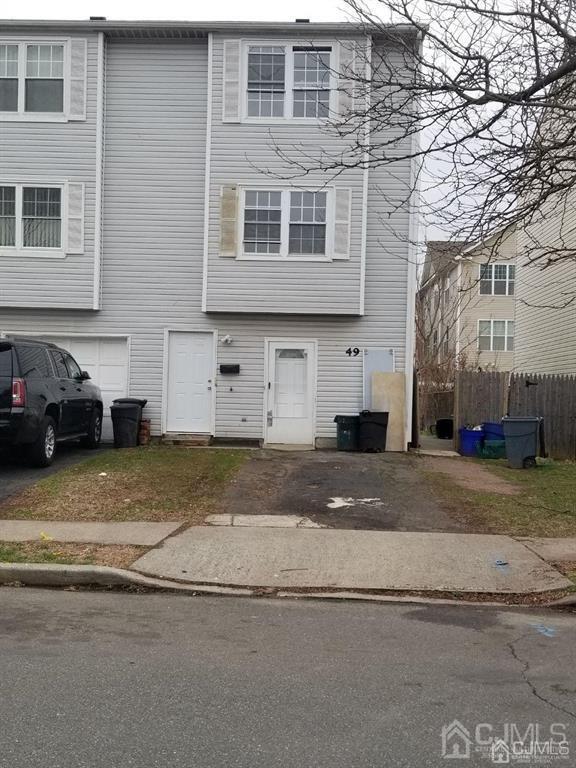
49 Larch St
Carteret, NJ 07008