
$2,500 / Month
49 Clark St
Framingham, MA 01702
Today
Favorites
617-877-4069
-
Bedrooms
2
-
Bathrooms
1
-
Square Feet
--
-
Available
Available Now
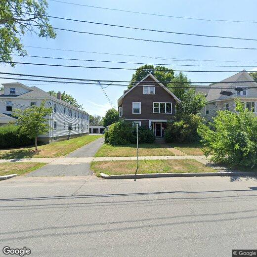
49 Clark St

Favorites
About This Home
$2,500 deposit,
Available Now
This is the entire first floor of a Framingham Multi-Family home. Very convenient location to shopping and main roads and attractions.
49 Clark St is a house located in Middlesex County and the 01702 ZIP Code. This area is served by the Framingham attendance zone.
* Price shown is base rent and may not include non-optional fees and utilities.
Price, availability, fees, and any applicable rent special are subject to change without notice.
* Square footage definitions vary. Displayed square footage is approximate.
Contact
- Listed by Larry Strasner
- Phone Number
- Contact
Location
Get Directions
Just west of Boston and East of Worcester sits Metro West, a region that houses a group of towns and cities with significant historical backgrounds. A total of 19 municipalities make up the core of this community, but other municipalities are considered to be a part of the Interstate 495/Metro West Corridor.
Learn more about living in Metro West
Education
| Colleges & Universities | Distance | ||
|---|---|---|---|
| Colleges & Universities | Distance | ||
| Drive: | 6 min | 2.2 mi | |
| Drive: | 15 min | 6.4 mi | |
| Drive: | 17 min | 8.4 mi | |
| Drive: | 23 min | 12.5 mi |
49 Clark St is within 6 minutes or 2.2 miles from Framingham State College. It is also near Wellesley College and Babson College.
Schools


Public Elementary School
Grades K-5
550 Students
Attendance Zone
Public Elementary School
Grades K-5
696 Students
Attendance Zone
Public Elementary School
Grades PK-5
401 Students
Nearby
Public Middle School
Grades 6-8
616 Students
Attendance Zone
Public Middle School
Grades 6-8
789 Students
Attendance Zone
Public High School
Grades 9-12
2,566 Students
Attendance Zone
Private Elementary & Middle School
Grades PK-8
174 Students
Nearby
Private High School
Grades 9-12
227 Students
Nearby
School data provided by
 The GreatSchools Rating helps parents compare schools within a state based on a variety of school quality indicators and provides a helpful picture of how effectively each school serves all of its students. Ratings are on a scale of 1 (below average) to 10 (above average) and can include test scores, college readiness, academic progress, advanced courses, equity, discipline and attendance data. We also advise parents to visit schools, consider other information on school performance and programs, and consider family needs as part of the school selection process.
View GreatSchools Rating Methodology
Data provided by GreatSchools.org © 2025. All rights reserved.
View GreatSchools Rating Methodology
Data provided by GreatSchools.org © 2025. All rights reserved.
Transportation options available in Framingham include Woodland, located 10.7 miles from 49 Clark St. 49 Clark St is near General Edward Lawrence Logan International, located 24.6 miles or 37 minutes away, and Worcester Regional, located 26.2 miles or 46 minutes away.
| Transit / Subway | Distance | ||
|---|---|---|---|
| Transit / Subway | Distance | ||
| Drive: | 19 min | 10.7 mi | |
| Drive: | 20 min | 11.4 mi | |
| Drive: | 20 min | 11.4 mi |
| Commuter Rail | Distance | ||
|---|---|---|---|
| Commuter Rail | Distance | ||
|
|
Walk: | 15 min | 0.8 mi |
| Drive: | 4 min | 1.5 mi | |
| Drive: | 8 min | 3.8 mi | |
| Drive: | 12 min | 4.9 mi | |
| Drive: | 16 min | 7.4 mi |
| Airports | Distance | ||
|---|---|---|---|
| Airports | Distance | ||
|
General Edward Lawrence Logan International
|
Drive: | 37 min | 24.6 mi |
|
Worcester Regional
|
Drive: | 46 min | 26.2 mi |
Time and distance from 49 Clark St.
| Shopping Centers | Distance | ||
|---|---|---|---|
| Shopping Centers | Distance | ||
| Walk: | 9 min | 0.5 mi | |
| Walk: | 12 min | 0.6 mi | |
| Drive: | 4 min | 1.3 mi |
49 Clark St has 3 shopping centers within 1.3 miles, which is about a 4-minute walk. The miles and minutes will be for the farthest away property.
| Parks and Recreation | Distance | ||
|---|---|---|---|
| Parks and Recreation | Distance | ||
|
Callahan State Park
|
Drive: | 9 min | 4.4 mi |
|
Cowassock Woods and Ashland Town Forest
|
Drive: | 11 min | 4.5 mi |
|
Hop Brook Natural Area
|
Drive: | 10 min | 4.6 mi |
|
Ashland State Park
|
Drive: | 13 min | 5.2 mi |
|
Cochituate State Park
|
Drive: | 18 min | 11.0 mi |
49 Clark St has 5 parks within 11.0 miles, including Cochituate State Park, Callahan State Park, and Cowassock Woods and Ashland Town Forest.
| Hospitals | Distance | ||
|---|---|---|---|
| Hospitals | Distance | ||
| Walk: | 10 min | 0.5 mi | |
| Drive: | 20 min | 10.3 mi | |
| Drive: | 18 min | 10.4 mi |
49 Clark St has 3 hospitals within 10.4 miles, the nearest is MetroWest Medical Center which is 0.5 mile away and a 10 minute walk.
| Military Bases | Distance | ||
|---|---|---|---|
| Military Bases | Distance | ||
| Drive: | 9 min | 3.9 mi | |
| Drive: | 33 min | 17.2 mi |
49 Clark St is 3.9 miles from US Military Reservation, and is convenient to other military bases, including Hanscom Air Force Base.
You May Also Like
Similar Rentals Nearby


What Are Walk Score®, Transit Score®, and Bike Score® Ratings?
Walk Score® measures the walkability of any address. Transit Score® measures access to public transit. Bike Score® measures the bikeability of any address.
What is a Sound Score Rating?
A Sound Score Rating aggregates noise caused by vehicle traffic, airplane traffic and local sources

49 Clark St
Framingham, MA 01702