
$2,400
/ Month
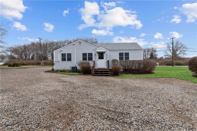
483 Boston Neck Rd
Narragansett, RI 02882
Favorites
483 Boston Neck Rd

Favorites
Check Back Soon for Upcoming Availability
| Beds | Baths | Average SF |
|---|---|---|
| 1 Bedroom 1 Bedroom 1 Br | 1 Bath 1 Bath 1 Ba | 750 SF |
Fees and Policies
The fees listed below are community-provided and may exclude utilities or add-ons. All payments are made directly to the property and are non-refundable unless otherwise specified.
Details
Utilities Included
-
Heat
-
Air Conditioning
About This Property
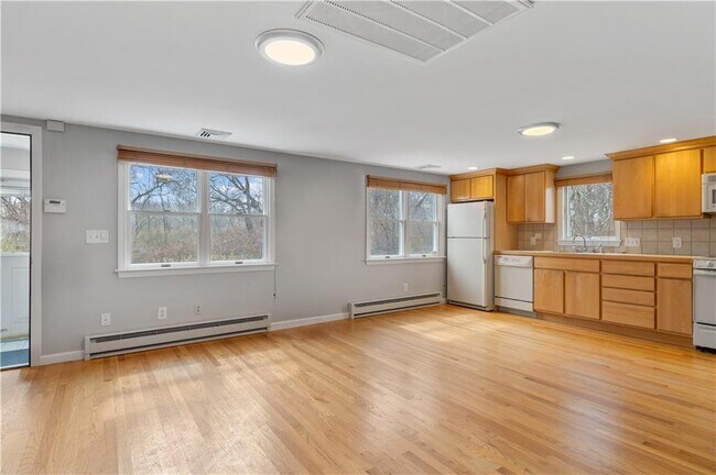
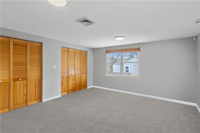
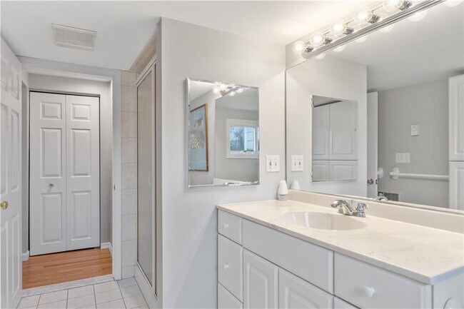
LOCATED BETWEEN ANAWAN CLIFFS AND NARRAGANSETT TOWN BEACH! Yearly rental in a prime Narragansett location close to beaches, restaurants, Narrow River, and bike path, this bright, spacious 1 bedroom apartment with its own private entrance is a rare find. Apartment features hardwood floors, open kitchen/dining/living area, a large bedroom with double closets, tile bath with walk-in shower, 5x4 storage area with shelving and plenty of cabinetry for storage. Price includes all utilities, trash removal and landscaping.
483 Boston Neck Rd is an apartment community located in Washington County and the 02882 ZIP Code.
Features
Air Conditioning
Dishwasher
Hardwood Floors
Microwave
- Air Conditioning
- Security System
- Fireplace
- Dishwasher
- Microwave
- Range
- Refrigerator
- Hardwood Floors
- Carpet
- Tile Floors
- Attic
- Views
- Pool
- Waterfront
483 Boston Neck Rd,
Narragansett,
RI
02882
Wedged between the Narrow River and the Atlantic Ocean, Narragansett provides that laidback, beach town atmosphere wrapped in New England charm. The town itself is adorable, complete with cozy cottages and a terrific shopping area along South Pier Road and Point Judith Road. It has that historic charm, as well, with a history that began around 1723, when it was still part of South Kingstown. In 1888 it separated from the larger city and became a town in 1901.
But cozy atmosphere and history aside, here it’s all about the beaches. Narragansett’s population doubles during the summer months, with visitors seeking the town’s beautiful strip of beaches. The 60-acre Scarborough State Beach includes an observation tower and a boardwalk, Roger W. Wheeler State Beach includes a playground and a pavilion, and Salty Brine State Beach has a “green” pavilion complete with a wind turbine and solar panels along with a concession stand.
Learn more about living in Narragansett
Amenities
- Air Conditioning
- Security System
- Fireplace
- Dishwasher
- Microwave
- Range
- Refrigerator
- Hardwood Floors
- Carpet
- Tile Floors
- Attic
- Views
- Waterfront
- Pool
Expenses
Utilities Included
Heat, Air Conditioning
Included
Education
| Colleges & Universities | Distance | ||
|---|---|---|---|
| Colleges & Universities | Distance | ||
| Drive: | 6 min | 3.7 mi | |
| Drive: | 14 min | 8.2 mi | |
| Drive: | 22 min | 13.9 mi | |
| Drive: | 26 min | 15.0 mi |
483 Boston Neck Rd is within 6 minutes or 3.7 miles from Rhode Island, Narragansett. It is also near Univ. Rhode Island, Kingston and C.C. of Rhode Island, Newport.
Walkability Near 483 Boston Neck Rd Narragansett, RI 02882
Getting Around
 What do Walkability, Transit, Drivability, and Bikeability mean?
Walkability measures the walking distance to day-to-day needs.
Transit measures access to public transportation.
Drivability measures congestion, parking availability, and access to major roads.
Bikeability measures the suitability for cycling.
How It Works
What do Walkability, Transit, Drivability, and Bikeability mean?
Walkability measures the walking distance to day-to-day needs.
Transit measures access to public transportation.
Drivability measures congestion, parking availability, and access to major roads.
Bikeability measures the suitability for cycling.
How It Works
Somewhat Walkable
Walkability
20
/ 100
Limited Public Transit
Transit
30
/ 100
Exceptionally Drivable
Drivability
100
/ 100
Somewhat Bikeable
Bikeability
20
/ 100
Scores provided by
-
Soundscore™
-
/ 100
Traffic
-Airport
-Businesses
-Scores provided by
HowLoud What is a Sound Score Rating? A Sound Score Rating aggregates noise caused by vehicle traffic, airplane traffic and local sources. How It WorksYou May Also Like
-
Ashworth Lofts
89 Globe Mills Ave
Fall River, MA 02724
$1,995 - $2,250 Plus Fees
1-2 Br 21.1 mi
-
Downtown Lofts
170 Pleasant St
Fall River, MA 02721
$1,597 - $2,075 Plus Fees
1 Br 12 Month Lease 22.5 mi
-
Commonwealth Landing Lofts
1082 Davol St
Fall River, MA 02720
$1,950 - $3,400 Plus Fees
1-3 Br 12 Month Lease 23.4 mi
Similar Rentals Nearby
-
-
-
-
1 Bed$2,310+2 Beds$3,047Total Monthly Price12 Month LeaseTotal Monthly Price NewPrices include base rent and required monthly fees of $6. Variable costs based on usage may apply.Base Rent:1 Bed$2,303+2 Beds$3,040
Pets Allowed Fitness Center Pool Dishwasher In Unit Washer & Dryer Balcony Stainless Steel Appliances
-
-
-
-
-
-
3 Beds$3,260+Total Monthly PriceTotal Monthly Price NewPrices include all required monthly fees.Discounts
Pets Allowed Fitness Center Dishwasher Kitchen Clubhouse Range


What Are Walk Score®, Transit Score®, and Bike Score® Ratings?
Walk Score® measures the walkability of any address. Transit Score® measures access to public transit. Bike Score® measures the bikeability of any address.
What is a Sound Score Rating?
A Sound Score Rating aggregates noise caused by vehicle traffic, airplane traffic and local sources.

483 Boston Neck Rd
Narragansett, RI 02882