
$3,500
Total Monthly Price
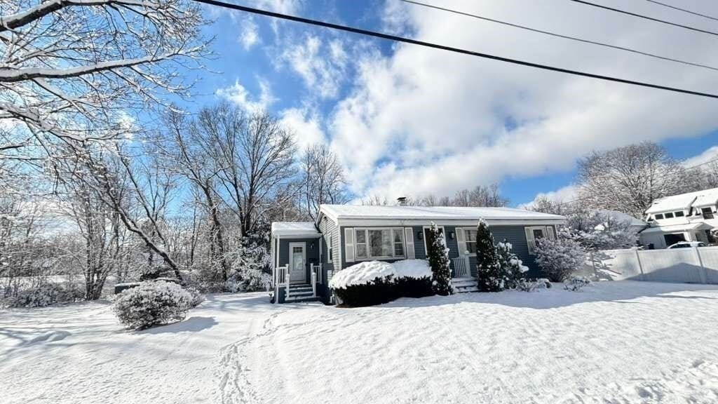
48 High St
Westborough, MA 01581
Today
|
Edit
Favorites
508-389-3053
-
Bedrooms
3
-
Bathrooms
1
-
Square Feet
914 sq ft
-
Available
Available Now
Highlights
- No Cooling
- Park
- Shops
- Property is near schools
- Electric Baseboard Heater
- Washer and Dryer
48 High St

Favorites
About This Home
Available Now
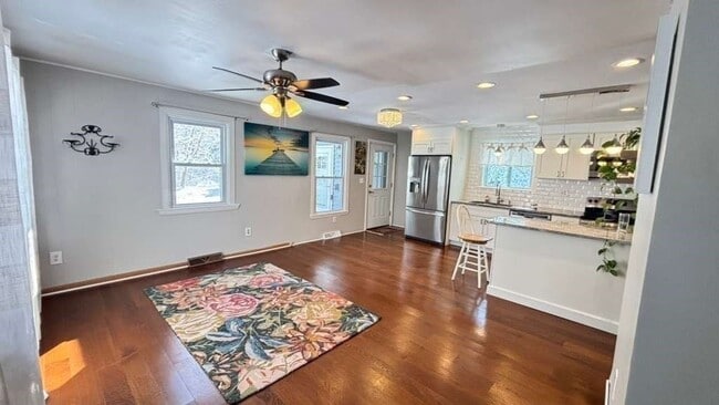
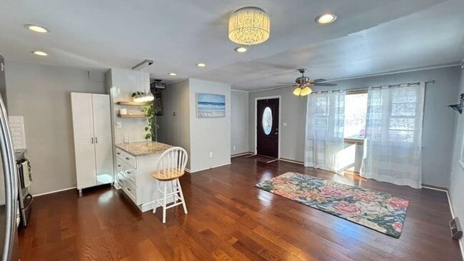
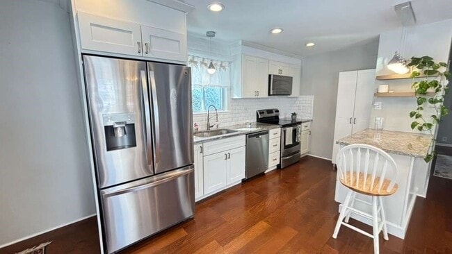
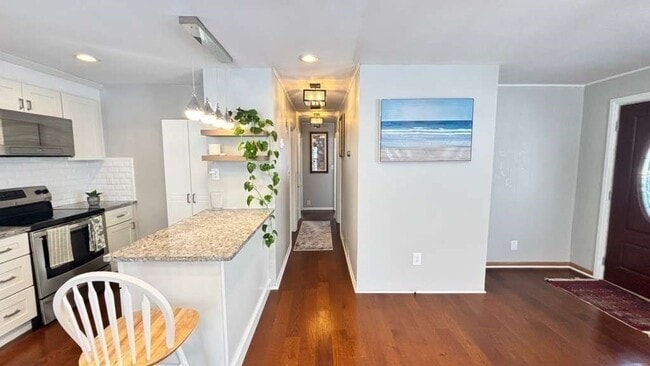
Welcome to 48 High Street in Westborough! This lovely home offers 3 bedrooms and 1 bathroom with plenty of space to relax and entertain. The updated kitchen and cozy living areas make it perfect for everyday life,while the backyard is ideal for enjoying sunny days or hosting friends. Located just minutes from downtown,shops,restaurants,and major highways,everything you need is close by. A comfortable,move-in-ready home waiting for you! MLS# 73470574
48 High St is a house located in Worcester County and the 01581 ZIP Code. This area is served by the Westborough attendance zone.
* Price shown is total price based on community-supplied monthly required fees. Excludes user-selected optional fees and variable or usage-based fees and required charges due at or prior to move-in or at move-out. Price, availability, fees, and any applicable rent special are subject to change without notice.
* Square footage definitions vary. Displayed square footage is approximate.
Home Details
Home Type
Single Family Detached Home
Bedrooms and Bathrooms
1 Full Bathroom
3 Bedrooms
Home Design
Entry on the 1st floor
Interior Spaces
914 Sq Ft Home
Kitchen
Range
Freezer
Microwave
Dishwasher
Laundry
Washer and Dryer
Laundry in unit
Listing and Financial Details
Assessor Parcel Number 1735899
Rent includes parking
Location
Property is near schools
Lot Details
0.36 Acre Lot
Parking
3 Open Parking Spaces
3 Car Parking Spaces
Utilities
No Cooling
Electric Baseboard Heater
Community Details
Amenities
Shops
Overview
No Home Owners Association
Pet Policy
Call for details about the types of pets allowed
Recreation
Park
Fees and Policies
The fees below are based on community-supplied data and may exclude additional fees and utilities.
-
One-Time Basics
-
Due at Move-In
-
Security Deposit - RefundableCharged per unit.$0
-
-
Due at Move-In
Property Fee Disclaimer: Based on community-supplied data and independent market research. Subject to change without notice. May exclude fees for mandatory or optional services and usage-based utilities.
Contact
- Listed by Leomara Lacerda Silva | Mega Realty Services
- Phone Number
-
Source
 MLS Property Information Network
The property listing data and information set forth herein were provided to MLS Property Information Network, Inc. from third party sources, including sellers, lessors and public records, and were compiled by MLS Property Information Network, Inc. The property listing data and information are for the personal, non-commercial use of consumers having a good faith interest in purchasing or leasing listed properties of the type displayed to them and may not be used for any purpose other than to identify prospective properties which such consumers may have a good faith interest in purchasing or leasing. MLS Property Information Network, Inc. and its subscribers disclaim any and all representations and warranties as to the accuracy of the property listing data and information set forth herein. All properties are subject to prior sale, change or withdrawal. Copyright © 2026 MLS Property Information Network, Inc. All rights reserved.
Location
Get Directions
Amenities
- Dishwasher
- Microwave
- Range
- Refrigerator
- Freezer
Situated just moments east of Worcester is the Route 9 Corridor, a large neighborhood compiled of several communities including Shrewsbury, Westborough, Northborough, and Southborough. Not only is Worcester at residents’ fingertips, but Downtown Boston is less than 40 miles east. The Route 9 Corridor is a commuter’s dream, offering easy city access and entry onto Interstates 290, 495, and 90.
The suburb is dotted with ponds, reservoirs, brooks, and rivers, providing ample outdoor recreation. Renters craving a beach day can bask on the sunny shores of Lake Chauncy Beach. Route 9 Corridor’s Prospect Park allows locals to take their dog for a stroll while Assabet Park gives children ample space to play on the playground. Those looking for winter recreation won’t want to miss the powdery slopes of Ski Ward Ski Area. No matter the season, renters settling in this diverse community can choose from gorgeous apartments ranging in price and amenities.
Learn more about living in Route 9 Corridor
Education
| Colleges & Universities | Distance | ||
|---|---|---|---|
| Colleges & Universities | Distance | ||
| Drive: | 11 min | 4.8 mi | |
| Drive: | 16 min | 9.4 mi | |
| Drive: | 18 min | 9.9 mi | |
| Drive: | 19 min | 11.3 mi |
48 High St is within 11 minutes or 4.8 miles from Tufts University, Grafton. It is also near Stillman College and Framingham State College.
Schools


Public Elementary School
Grades PK-3
475 Students
Attendance Zone
Public Elementary School
Grades 4-6
865 Students
Attendance Zone
Public Middle School
Grades 7-8
590 Students
Attendance Zone
Public High School
Grades 9-12
1,178 Students
Attendance Zone
Private Elementary School
Grades PK-K
95 Students
Nearby
Private Elementary & Middle School
Grades PK-8
Nearby
Private Elementary & Middle School
Grades K-9
467 Students
Nearby
Private High School
Grades 9-12
365 Students
Nearby
School data provided by
 The GreatSchools Rating helps parents compare schools within a state based on a variety of school quality indicators and provides a helpful picture of how effectively each school serves all of its students. Ratings are on a scale of 1 (below average) to 10 (above average) and can include test scores, college readiness, academic progress, advanced courses, equity, discipline and attendance data. We also advise parents to visit schools, consider other information on school performance and programs, and consider family needs as part of the school selection process.
View GreatSchools Rating Methodology
Data provided by GreatSchools.org © 2026. All rights reserved.
View GreatSchools Rating Methodology
Data provided by GreatSchools.org © 2026. All rights reserved.
You May Also Like
Similar Rentals Nearby


What Are Walk Score®, Transit Score®, and Bike Score® Ratings?
Walk Score® measures the walkability of any address. Transit Score® measures access to public transit. Bike Score® measures the bikeability of any address.
What is a Sound Score Rating?
A Sound Score Rating aggregates noise caused by vehicle traffic, airplane traffic and local sources

48 High St
Westborough, MA 01581