
$1,750
/ Month
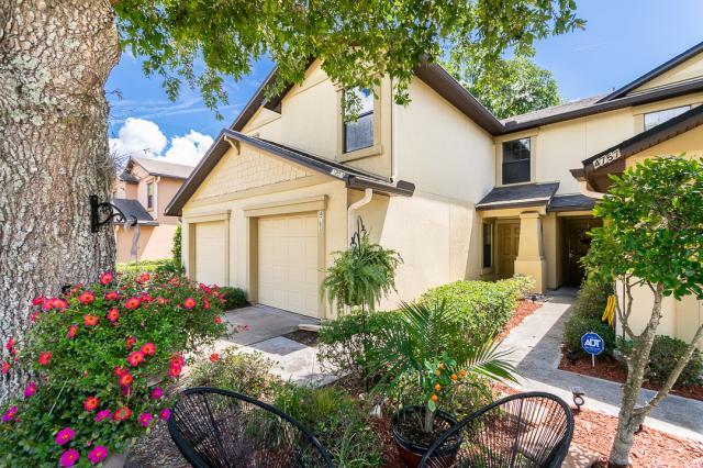
4753 Playschool Dr
Jacksonville, FL 32210
2 Weeks Ago
|
Edit
Favorites
4753 Playschool Dr

Favorites
Check Back Soon for Upcoming Availability
| Beds | Baths | Average SF |
|---|---|---|
| 3 Bedrooms 3 Bedrooms 3 Br | 2.5 Baths 2.5 Baths 2.5 Ba | 1,532 SF |
About This Property
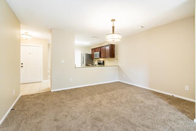
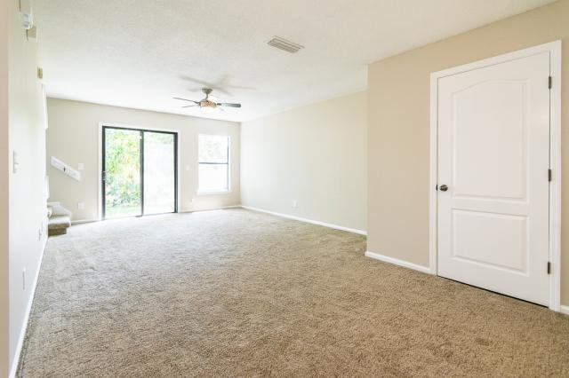
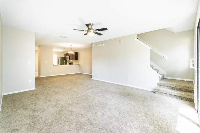
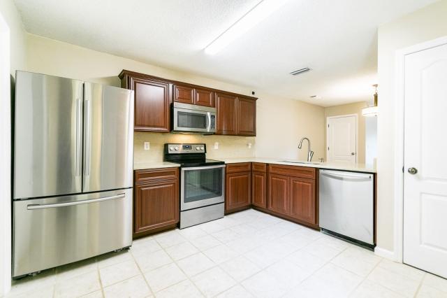
APS80393308 - Welcome home to this beautiful 3 bedroom, 2.5 bathroom townhome located in Timothy's Landing with pool and amenities! Close to shopping, restaurants and convenient to NAS Jax, Cecil Field, and I-295. Recently painted, upgraded carpet, granite counters DELUX, resort-like living. Open floorplan w/upstairs laundry (washer/dryer included), large kitchen w/breakfast bar and separate dining area. Functional living room, half bath, and sliding doors to private patio. Upstairs bedrooms include ample closet space. Attached 1 car garage. Utilities and alarm monitoring tenant expense. No pets or smoking! Renters insurance required prior to move-in.
4753 Playschool Dr is a house located in Duval County and the 32210 ZIP Code. This area is served by the Duval County Public Schools attendance zone.
Location
Get Directions
Jacksonville Heights is a suburban community less than 15 miles southwest of Jacksonville. The town features peaceful neighborhoods, good schools, and modern amenities along 103rd Street. Renters have the choice between affordable to moderately priced apartments and ranch-style homes. Thanks to Interstate 295 being in proximity to Jacksonville Heights, driving to surrounding areas is a breeze. Residents can travel west for about 10 miles to hit Saint Johns River or keep going west for about 30 minutes to get to the Atlantic Coast.
Learn more about living in Jacksonville HeightsBelow are rent ranges for similar nearby apartments
Education
| Colleges & Universities | Distance | ||
|---|---|---|---|
| Colleges & Universities | Distance | ||
| Drive: | 21 min | 10.9 mi | |
| Drive: | 22 min | 12.4 mi | |
| Drive: | 32 min | 16.2 mi | |
| Drive: | 30 min | 18.8 mi |
4753 Playschool Dr is within 21 minutes or 10.9 miles from Fla. State Coll. Jacksonville. It is also near St. Johns River, Orange Park and Jacksonville University.
Schools


Public Elementary School
Grades PK-5
Nearby
Public Elementary School
Grades PK-5
530 Students
Attendance Zone
Public Middle School
Grades 6-8
992 Students
Attendance Zone
Public High School
Grades 9-12
1,583 Students
Attendance Zone
Private Elementary, Middle & High School
Grades K-12
Nearby
Private Elementary, Middle & High School
Grades K-12
90 Students
Nearby
Private Elementary School
Grades PK-5
Nearby
Private Elementary School
Grades K-6
Nearby
School data provided by
 The GreatSchools Rating helps parents compare schools within a state based on a variety of school quality indicators and provides a helpful picture of how effectively each school serves all of its students. Ratings are on a scale of 1 (below average) to 10 (above average) and can include test scores, college readiness, academic progress, advanced courses, equity, discipline and attendance data. We also advise parents to visit schools, consider other information on school performance and programs, and consider family needs as part of the school selection process.
View GreatSchools Rating Methodology
Data provided by GreatSchools.org © 2025. All rights reserved.
View GreatSchools Rating Methodology
Data provided by GreatSchools.org © 2025. All rights reserved.
Transportation options available in Jacksonville include Convention Center, located 10.0 miles from 4753 Playschool Dr. 4753 Playschool Dr is near Jacksonville International, located 21.8 miles or 33 minutes away.
| Transit / Subway | Distance | ||
|---|---|---|---|
| Transit / Subway | Distance | ||
|
|
Drive: | 18 min | 10.0 mi |
|
|
Drive: | 18 min | 10.1 mi |
|
|
Drive: | 19 min | 10.7 mi |
|
|
Drive: | 20 min | 10.8 mi |
|
|
Drive: | 22 min | 12.8 mi |
| Commuter Rail | Distance | ||
|---|---|---|---|
| Commuter Rail | Distance | ||
|
|
Drive: | 20 min | 11.3 mi |
| Airports | Distance | ||
|---|---|---|---|
| Airports | Distance | ||
|
Jacksonville International
|
Drive: | 33 min | 21.8 mi |
Time and distance from 4753 Playschool Dr.
| Shopping Centers | Distance | ||
|---|---|---|---|
| Shopping Centers | Distance | ||
| Walk: | 15 min | 0.8 mi | |
| Walk: | 19 min | 1.0 mi | |
| Drive: | 3 min | 1.2 mi |
4753 Playschool Dr has 3 shopping centers within 1.2 miles, which is about a 3-minute walk. The miles and minutes will be for the farthest away property.
| Parks and Recreation | Distance | ||
|---|---|---|---|
| Parks and Recreation | Distance | ||
|
McGirts Creek Park
|
Drive: | 9 min | 3.1 mi |
|
Ringhaver Park
|
Drive: | 11 min | 4.9 mi |
|
Crystal Springs Road Park
|
Drive: | 15 min | 6.6 mi |
|
Fowler Regional Park
|
Drive: | 13 min | 7.2 mi |
|
Jacksonville-Baldwin Rail Trail
|
Drive: | 14 min | 7.8 mi |
4753 Playschool Dr has 5 parks within 7.8 miles, including McGirts Creek Park, Ringhaver Park, and Crystal Springs Road Park.
| Hospitals | Distance | ||
|---|---|---|---|
| Hospitals | Distance | ||
| Drive: | 17 min | 8.0 mi | |
| Drive: | 14 min | 8.5 mi | |
| Drive: | 19 min | 9.0 mi |
4753 Playschool Dr has 3 hospitals within 9.0 miles, the nearest is Ascension St. Vincent's Riverside which is 8.0 miles away and a 17 minute drive.
| Military Bases | Distance | ||
|---|---|---|---|
| Military Bases | Distance | ||
| Drive: | 14 min | 7.9 mi | |
| Drive: | 18 min | 8.9 mi |
4753 Playschool Dr is 7.9 miles from Cecil Field Naval Air Station, and is convenient to other military bases, including Jacksonville Naval Air Station.
You May Also Like
Similar Rentals Nearby


What Are Walk Score®, Transit Score®, and Bike Score® Ratings?
Walk Score® measures the walkability of any address. Transit Score® measures access to public transit. Bike Score® measures the bikeability of any address.
What is a Sound Score Rating?
A Sound Score Rating aggregates noise caused by vehicle traffic, airplane traffic and local sources
4753 Playschool Dr
Jacksonville, FL 32210