
Mont Clare
7171 W Gunnison St,
Harwood Heights, IL 60706
$1,250 - $1,685
Studio - 2 Beds


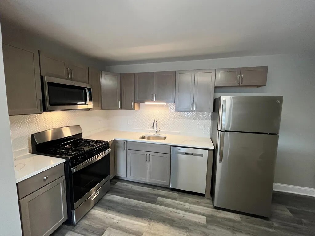
Spectacular quartz countertop, and high quality cabinetry. Updated bathroom with tub. Laundry in the building. This apartment is in a Central location for easy commute, allows Mins to Exprswy and O'Hare Airport. Close to all major stores, easy street parking. Close to Harlem Blue line station. Tenant pays for all utilities.
Spectacular quartz countertop, and high quality cabinetry. Updated bathroom with tub. Laundry in the building. This apartment is in a Central location for easy commute, allows Mins to Exprswy and O'Hare Airport. Close to all major stores, easy street parking. Close to Harlem Blue line station. Tenant pays for all utilities.
4747 N Ronald St is an apartment community located in Cook County and the 60706 ZIP Code. This area is served by the Union Ridge School District 86 attendance zone.
Harwood Heights is a small, self-governing village in Cook County that forms a quiet enclave completely surrounded by the city of Chicago. Covering just one square mile and home to roughly 9,000 residents, it carries the feel of a tight-knit suburb while sitting about 20 minutes northwest of the Loop via the Kennedy Expressway. The village has charted an independent course since the 1940s, when Chicago declined to annex it, and that spirit of self-determination still shapes its identity today. Norridge, its closest neighbor, shares the same enclave and offers additional retail and dining along the Harlem Avenue corridor.
Housing in Harwood Heights skews toward well-maintained apartment communities, with a mix of mid-rise buildings and garden-style units that reflect the area's postwar growth era.
Learn more about living in Harwood Heights| Colleges & Universities | Distance | ||
|---|---|---|---|
| Colleges & Universities | Distance | ||
| Drive: | 4 min | 1.5 mi | |
| Drive: | 14 min | 5.0 mi | |
| Drive: | 13 min | 5.6 mi | |
| Drive: | 13 min | 6.0 mi |


Transportation options available in Harwood Heights include Harlem Station (Blue Line - O'hare Branch), located 3.0 miles from 4747 N Ronald St Unit GB. 4747 N Ronald St Unit GB is near Chicago O'Hare International, located 6.7 miles or 12 minutes away, and Chicago Midway International, located 15.5 miles or 29 minutes away.
| Transit / Subway | Distance | ||
|---|---|---|---|
| Transit / Subway | Distance | ||
|
|
Drive: | 6 min | 3.0 mi |
|
|
Drive: | 6 min | 3.0 mi |
|
|
Drive: | 9 min | 4.8 mi |
|
|
Drive: | 9 min | 4.9 mi |
|
|
Drive: | 10 min | 5.4 mi |
| Commuter Rail | Distance | ||
|---|---|---|---|
| Commuter Rail | Distance | ||
|
|
Drive: | 5 min | 2.6 mi |
|
|
Drive: | 6 min | 2.7 mi |
|
|
Drive: | 6 min | 2.8 mi |
|
|
Drive: | 7 min | 3.5 mi |
|
|
Drive: | 8 min | 3.8 mi |
| Airports | Distance | ||
|---|---|---|---|
| Airports | Distance | ||
|
Chicago O'Hare International
|
Drive: | 12 min | 6.7 mi |
|
Chicago Midway International
|
Drive: | 29 min | 15.5 mi |
Scores provided by
Traffic
-Airport
-Businesses
-Scores provided by
HowLoud What is a Sound Score Rating? A Sound Score Rating aggregates noise caused by vehicle traffic, airplane traffic and local sources. How It WorksTime and distance from 4747 N Ronald St Unit GB.
| Shopping Centers | Distance | ||
|---|---|---|---|
| Shopping Centers | Distance | ||
| Walk: | 5 min | 0.3 mi | |
| Walk: | 6 min | 0.4 mi | |
| Walk: | 7 min | 0.4 mi |
| Parks and Recreation | Distance | ||
|---|---|---|---|
| Parks and Recreation | Distance | ||
|
Oriole Park
|
Drive: | 4 min | 1.4 mi |
|
Norwood Park
|
Drive: | 5 min | 1.9 mi |
|
Portage Park
|
Drive: | 6 min | 2.9 mi |
|
Caldwell Woods
|
Drive: | 7 min | 2.9 mi |
|
Catherine Chevalier Woods
|
Drive: | 6 min | 3.2 mi |
| Hospitals | Distance | ||
|---|---|---|---|
| Hospitals | Distance | ||
| Drive: | 3 min | 1.2 mi | |
| Drive: | 4 min | 1.8 mi | |
| Drive: | 7 min | 3.5 mi |
| Military Bases | Distance | ||
|---|---|---|---|
| Military Bases | Distance | ||
| Drive: | 21 min | 14.3 mi |
What Are Walk Score®, Transit Score®, and Bike Score® Ratings?
Walk Score® measures the walkability of any address. Transit Score® measures access to public transit. Bike Score® measures the bikeability of any address.
What is a Sound Score Rating?
A Sound Score Rating aggregates noise caused by vehicle traffic, airplane traffic and local sources.
4747 N Ronald St
Harwood Heights, IL 60706


