
Mont Clare
7171 W Gunnison St,
Harwood Heights, IL 60706
$1,042 - $1,535
Studio - 2 Beds


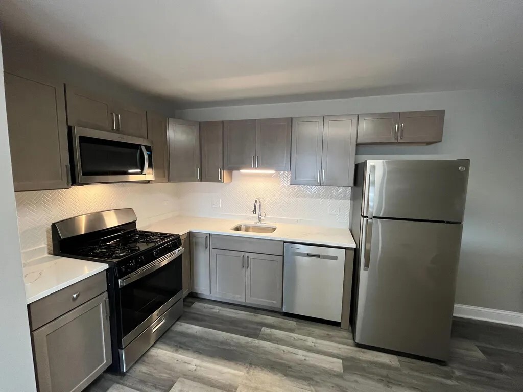
Spectacular quartz countertop, and high quality cabinetry. Updated bathroom with tub. Laundry in the building. This apartment is in a Central location for easy commute, allows Mins to Exprswy and O'Hare Airport. Close to all major stores, easy street parking. Close to Harlem Blue line station. Tenant pays for all utilities.
Spectacular quartz countertop, and high quality cabinetry. Updated bathroom with tub. Laundry in the building. This apartment is in a Central location for easy commute, allows Mins to Exprswy and O'Hare Airport. Close to all major stores, easy street parking. Close to Harlem Blue line station. Tenant pays for all utilities.
4747 N Ronald St is an apartment community located in Cook County and the 60706 ZIP Code. This area is served by the Union Ridge School District 86 attendance zone.
Take the Kennedy Expressway about 20 minutes northwest of Downtown Chicago to find Harwood Heights, a lesser-known suburb that combines small-town atmosphere with the convenience of a nearby big city. Secluded residential streets and a lively retail district along Harlem Avenue characterize this small village, and the Ridgemoor Country Club creates a scenic backdrop on the east side.
Residents enjoying a laid-back lifestyle make up this tight-knit neighborhood. Don’t be surprised if your fellow neighbors stop by for a chat or bring you an apartment-warming casserole. Old-fashioned courtesies remain very much alive – and there’s tons of shopping destinations in this cool town. Grab a bite to eat at the local café or play a game of hockey at Norridge Park.
Learn more about living in Harwood Heights| Colleges & Universities | Distance | ||
|---|---|---|---|
| Colleges & Universities | Distance | ||
| Drive: | 4 min | 1.5 mi | |
| Drive: | 14 min | 5.0 mi | |
| Drive: | 13 min | 5.6 mi | |
| Drive: | 13 min | 6.0 mi |


Transportation options available in Harwood Heights include Harlem Station (Blue Line - O'hare Branch), located 3.0 miles from 4747 N Ronald St Unit GB. 4747 N Ronald St Unit GB is near Chicago O'Hare International, located 6.7 miles or 12 minutes away, and Chicago Midway International, located 15.5 miles or 29 minutes away.
| Transit / Subway | Distance | ||
|---|---|---|---|
| Transit / Subway | Distance | ||
|
|
Drive: | 6 min | 3.0 mi |
|
|
Drive: | 6 min | 3.0 mi |
|
|
Drive: | 9 min | 4.8 mi |
|
|
Drive: | 9 min | 4.9 mi |
|
|
Drive: | 10 min | 5.4 mi |
| Commuter Rail | Distance | ||
|---|---|---|---|
| Commuter Rail | Distance | ||
|
|
Drive: | 5 min | 2.6 mi |
|
|
Drive: | 6 min | 2.7 mi |
|
|
Drive: | 6 min | 2.8 mi |
|
|
Drive: | 7 min | 3.5 mi |
|
|
Drive: | 8 min | 3.8 mi |
| Airports | Distance | ||
|---|---|---|---|
| Airports | Distance | ||
|
Chicago O'Hare International
|
Drive: | 12 min | 6.7 mi |
|
Chicago Midway International
|
Drive: | 29 min | 15.5 mi |
Time and distance from 4747 N Ronald St Unit GB.
| Shopping Centers | Distance | ||
|---|---|---|---|
| Shopping Centers | Distance | ||
| Walk: | 5 min | 0.3 mi | |
| Walk: | 6 min | 0.4 mi | |
| Walk: | 7 min | 0.4 mi |
| Parks and Recreation | Distance | ||
|---|---|---|---|
| Parks and Recreation | Distance | ||
|
Oriole Park
|
Drive: | 4 min | 1.4 mi |
|
Norwood Park
|
Drive: | 5 min | 1.9 mi |
|
Portage Park
|
Drive: | 6 min | 2.9 mi |
|
Caldwell Woods
|
Drive: | 7 min | 2.9 mi |
|
Catherine Chevalier Woods
|
Drive: | 6 min | 3.2 mi |
| Hospitals | Distance | ||
|---|---|---|---|
| Hospitals | Distance | ||
| Drive: | 3 min | 1.2 mi | |
| Drive: | 4 min | 1.8 mi | |
| Drive: | 7 min | 3.5 mi |
| Military Bases | Distance | ||
|---|---|---|---|
| Military Bases | Distance | ||
| Drive: | 21 min | 14.3 mi |
What Are Walk Score®, Transit Score®, and Bike Score® Ratings?
Walk Score® measures the walkability of any address. Transit Score® measures access to public transit. Bike Score® measures the bikeability of any address.
What is a Sound Score Rating?
A Sound Score Rating aggregates noise caused by vehicle traffic, airplane traffic and local sources
4747 N Ronald St
Harwood Heights, IL 60706


