
$6,950 / Month
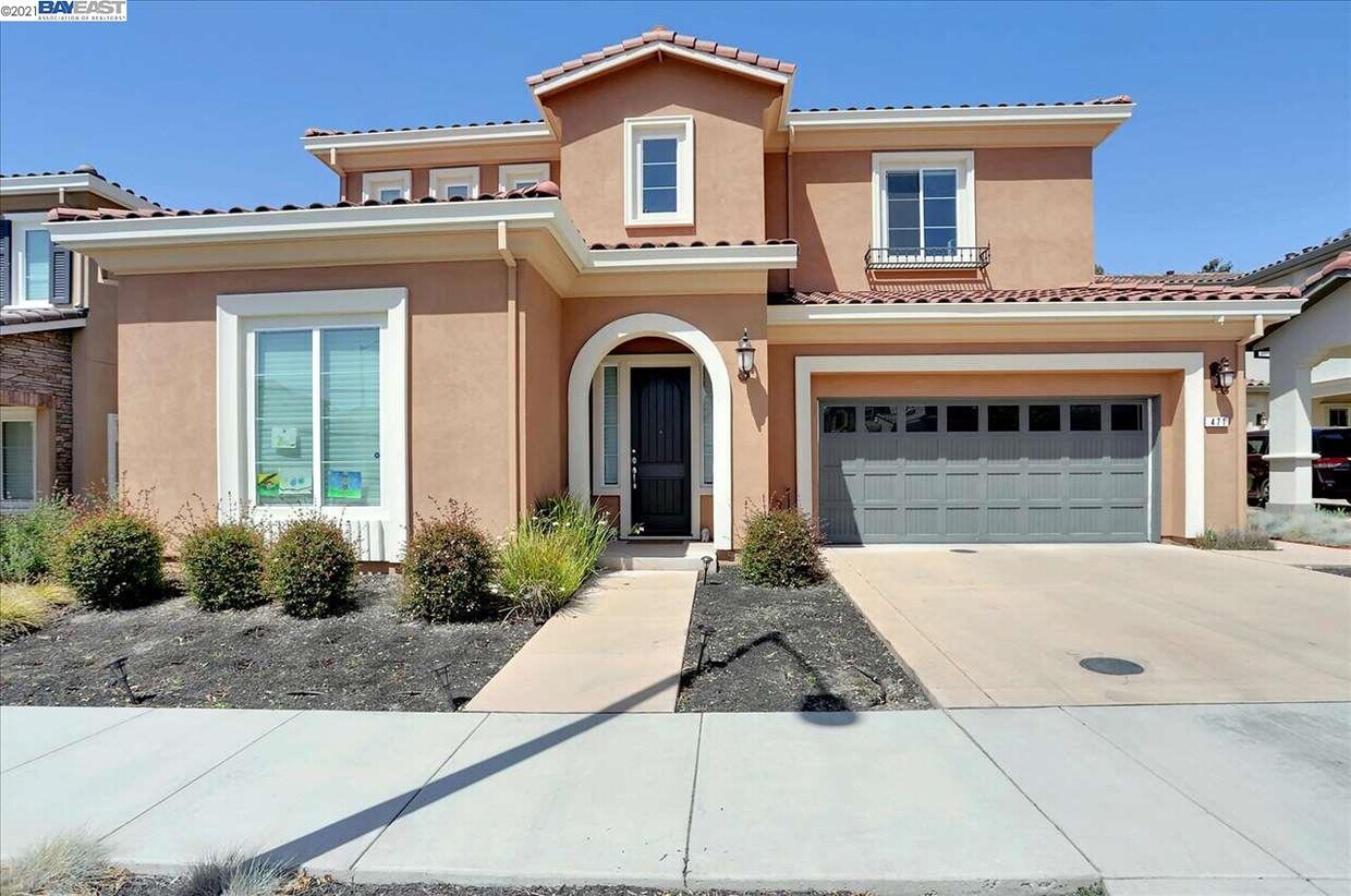
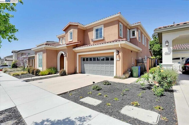
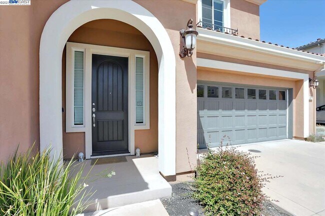
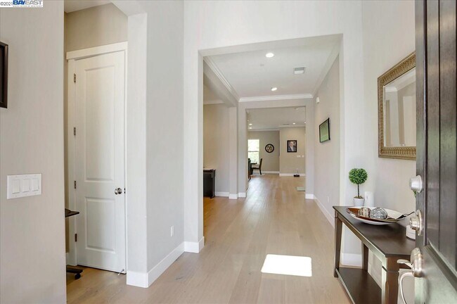
471 Tangelo Ct
Fremont, CA 94539
2 Weeks Ago
Favorites
471 Tangelo Ct

Favorites
Check Back Soon for Upcoming Availability
| Beds | Baths | Average SF |
|---|---|---|
| 5 Bedrooms 5 Bedrooms 5 Br | 4.5 Baths 4.5 Baths 4.5 Ba | 3,625 SF |
About This Property
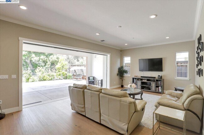
Almost brand new home*Top Mission schools*Lots of upgrades*Elegant, spacious and contemporary two-story, single family home with 4 bedrooms Plus office and 4.5 bathrooms* Crown molding*Family/Dining Combo*Very Spacious*Bright and Airy*Large open kitchen with marble counter tops*Upgraded stainless steel thermador appliances*Elegant cabinets*Upgraded neutral colors*Recess lights*Master suite with separate walk-in closets for his and her*Upgraded master bathroom with Stall shower and Sunken Tub*Good size home*Laundry room with washer/dryer and cabinet space*Beautifully landscaped backyard with fruit trees*Two car garage with Tesla Charger installed*Newer style foldable sliding door which opens up to the backyard makes it large area for party*Nicely done Front and back yard low maintenance *Close to top rated Mission Schools*Close to shopping, restaurants and parks.. Available to rent from August 1st, 2021* For showing call agent to schedule for showing. Minimum 1 year lease.
471 Tangelo Ct is a house located in Alameda County and the 94539 ZIP Code. This area is served by the Fremont Unified attendance zone.
Location
Get Directions
Fremont is a charming city in the San Francisco Bay Area that sits across the Bay from the Silicon Valley. It is known as an ideal destination for families, offering kid-friendly attractions and excellent public schools like the Children’s Natural History Museum and Washington High School. The rapid expansion of the tech industry in recent years has boosted Fremont’s reputation as a commuter-friendly city for those working in the Silicon Valley. Fremont is located directly north of San Jose, and Palo Alto is a short drive across the Dumbarton Bridge on the Bay.
Fremont’s local culture incorporates the area’s rich history and thriving arts scene. Check out the Old Town Niles region that features a popular art walk, antique fair, and a museum celebrating the town’s role in the early days of motion picture production. Exquisite historic architecture is on display around the city, so be sure to explore Fremont’s picturesque streets that blend urban amenities and suburban neighborhoods.
Learn more about living in FremontBelow are rent ranges for similar nearby apartments
Education
| Colleges & Universities | Distance | ||
|---|---|---|---|
| Colleges & Universities | Distance | ||
| Drive: | 7 min | 2.2 mi | |
| Drive: | 13 min | 5.7 mi | |
| Drive: | 25 min | 12.3 mi | |
| Drive: | 21 min | 12.6 mi |
471 Tangelo Ct is within 7 minutes or 2.2 miles from Ohlone College, Fremont Campus. It is also near Ohlone College, Newark and Palmer College of Chiropractic West Campus.
Schools


Public Elementary School
Grades 1-5
616 Students
Attendance Zone
Public Elementary School
Grades K-5
343 Students
Nearby
Public Middle School
Grades 6-8
909 Students
Attendance Zone
Public High School
Grades 9-12
1,878 Students
Attendance Zone
Private Elementary School
Grades PK-6
231 Students
Nearby
Private Elementary & Middle School
Grades K-8
217 Students
Nearby
Private Middle & High School
Grades 7-12
59 Students
Nearby
School data provided by
 The GreatSchools Rating helps parents compare schools within a state based on a variety of school quality indicators and provides a helpful picture of how effectively each school serves all of its students. Ratings are on a scale of 1 (below average) to 10 (above average) and can include test scores, college readiness, academic progress, advanced courses, equity, discipline and attendance data. We also advise parents to visit schools, consider other information on school performance and programs, and consider family needs as part of the school selection process.
View GreatSchools Rating Methodology
Data provided by GreatSchools.org © 2025. All rights reserved.
View GreatSchools Rating Methodology
Data provided by GreatSchools.org © 2025. All rights reserved.
Transportation options available in Fremont include Fremont Station, located 3.6 miles from 471 Tangelo Ct. 471 Tangelo Ct is near Norman Y Mineta San Jose International, located 16.6 miles or 25 minutes away, and Metro Oakland International, located 25.3 miles or 37 minutes away.
| Transit / Subway | Distance | ||
|---|---|---|---|
| Transit / Subway | Distance | ||
|
|
Drive: | 9 min | 3.6 mi |
|
|
Drive: | 10 min | 3.7 mi |
|
|
Drive: | 9 min | 4.1 mi |
|
|
Drive: | 16 min | 7.5 mi |
|
|
Drive: | 18 min | 11.2 mi |
| Commuter Rail | Distance | ||
|---|---|---|---|
| Commuter Rail | Distance | ||
| Drive: | 12 min | 4.9 mi | |
| Drive: | 12 min | 5.0 mi | |
| Drive: | 18 min | 12.3 mi | |
| Drive: | 18 min | 12.4 mi | |
| Drive: | 22 min | 14.2 mi |
| Airports | Distance | ||
|---|---|---|---|
| Airports | Distance | ||
|
Norman Y Mineta San Jose International
|
Drive: | 25 min | 16.6 mi |
|
Metro Oakland International
|
Drive: | 37 min | 25.3 mi |
Time and distance from 471 Tangelo Ct.
| Shopping Centers | Distance | ||
|---|---|---|---|
| Shopping Centers | Distance | ||
| Walk: | 20 min | 1.1 mi | |
| Drive: | 6 min | 1.6 mi | |
| Drive: | 6 min | 2.2 mi |
471 Tangelo Ct has 3 shopping centers within 2.2 miles, which is about a 6-minute walk. The miles and minutes will be for the farthest away property.
| Parks and Recreation | Distance | ||
|---|---|---|---|
| Parks and Recreation | Distance | ||
|
Central Park (Lake Elizabeth)
|
Drive: | 9 min | 3.4 mi |
|
Niles Canyon Railway
|
Drive: | 10 min | 4.5 mi |
|
Niles Community Park
|
Drive: | 12 min | 5.0 mi |
|
Mission Peak Regional Preserve
|
Drive: | 20 min | 5.5 mi |
|
Quarry Lakes Regional Recreation Area
|
Drive: | 13 min | 5.8 mi |
471 Tangelo Ct has 5 parks within 5.8 miles, including Central Park (Lake Elizabeth), Niles Canyon Railway, and Niles Community Park.
| Hospitals | Distance | ||
|---|---|---|---|
| Hospitals | Distance | ||
| Drive: | 7 min | 2.9 mi | |
| Drive: | 10 min | 3.8 mi |
471 Tangelo Ct is 2.9 miles from Kaiser Foundation Hospital - Fremont, and is convenient to other hospitals, including Washington Hospital.
| Military Bases | Distance | ||
|---|---|---|---|
| Military Bases | Distance | ||
| Drive: | 30 min | 19.4 mi |
471 Tangelo Ct is 19.4 miles and a 30 minute drive from Ames Research Center.
You May Also Like
Similar Rentals Nearby


What Are Walk Score®, Transit Score®, and Bike Score® Ratings?
Walk Score® measures the walkability of any address. Transit Score® measures access to public transit. Bike Score® measures the bikeability of any address.
What is a Sound Score Rating?
A Sound Score Rating aggregates noise caused by vehicle traffic, airplane traffic and local sources

471 Tangelo Ct
Fremont, CA 94539