

$1,650
/ Month
467 Chestnut Ave
Trenton, NJ 08611
2 Weeks Ago
|
Edit
Favorites
467 Chestnut Ave

Favorites
Check Back Soon for Upcoming Availability
| Beds | Baths | Average SF |
|---|---|---|
| 4 Bedrooms 4 Bedrooms 4 Br | 1 Bath 1 Bath 1 Ba | — |
About This Property
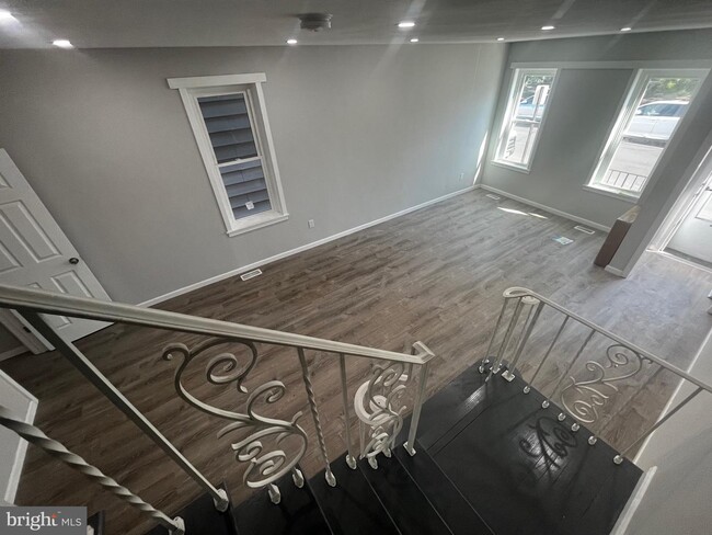
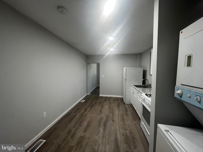
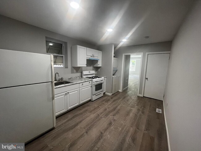
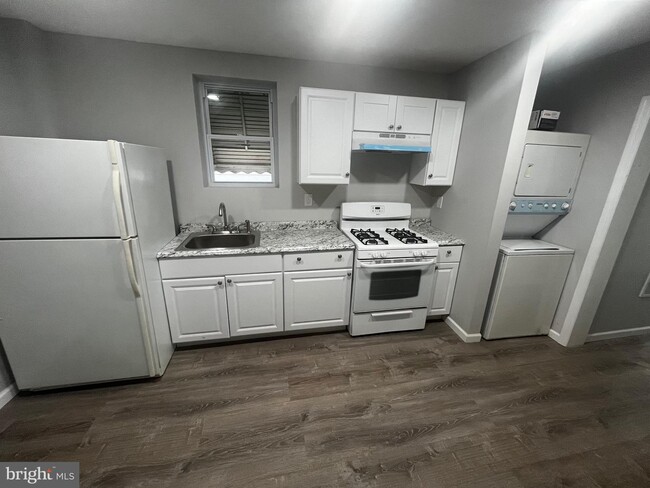
Welcome to this four (4) bedroom, one (1) bathroom single family unit; ready for you to make it your home. This unit is spacious in size and Move-In Ready has access to public transportation as well as is located across the street from a park. In addition to being priced right, this unit has basement access, washer/dryer and yard access in the rear of building. To qualify for this unit, all prospective tenants must complete rental process & have minimum requirements. Please don't delay, apply for this unit today!
467 Chestnut Ave is a townhome located in Mercer County and the 08611 ZIP Code. This area is served by the Trenton Public School District attendance zone.
Townhome Features
- Basement
467 Chestnut Ave,
Trenton,
NJ
08611
The historic Chambersburg neighborhood lies in southeast Trenton, New Jersey. Like much of Trenton, Chambersburg is filled with historic brick buildings, left over from the area’s industrial past; several of these buildings have been repurposed into apartments and retail space in recent years. Popularly known as "the 'Burg," the community has long been known for celebrating its Italian heritage, which cultivated a thriving restaurant scene over the years. As time has passed, the culinary scene has diversified with the population, and eateries like the Italian People’s Bakery on Butler and Mi Tierra on South Clinton continue to attract foodies from across the city. Locals also enjoy convenient access to the Sun National Bank Center arena and the Trenton Transit Center train station.
Learn more about living in ChambersburgBelow are rent ranges for similar nearby apartments
Amenities
- Basement
Education
| Colleges & Universities | Distance | ||
|---|---|---|---|
| Colleges & Universities | Distance | ||
| Drive: | 3 min | 1.5 mi | |
| Drive: | 12 min | 5.3 mi | |
| Drive: | 12 min | 6.4 mi | |
| Drive: | 17 min | 6.7 mi |
467 Chestnut Ave is within 3 minutes or 1.5 miles from Mercer Co. C.C., Kerney. It is also near The College of New Jersey and Rider Univ., Lawrenceville.
Schools


Public Elementary School
Grades K-5
542 Students
Nearby
Public Elementary School
Grades K-5
582 Students
Attendance Zone
Public Elementary School
Grades K-5
289 Students
Attendance Zone
Public High School
Grades 9-12
761 Students
Attendance Zone
Public High School
Grades 9-12
2,255 Students
Attendance Zone
Private Elementary, Middle & High School
Grades K-12
101 Students
Nearby
Private Elementary & Middle School
Grades PK-8
Nearby
School data provided by
 The GreatSchools Rating helps parents compare schools within a state based on a variety of school quality indicators and provides a helpful picture of how effectively each school serves all of its students. Ratings are on a scale of 1 (below average) to 10 (above average) and can include test scores, college readiness, academic progress, advanced courses, equity, discipline and attendance data. We also advise parents to visit schools, consider other information on school performance and programs, and consider family needs as part of the school selection process.
View GreatSchools Rating Methodology
Data provided by GreatSchools.org © 2026. All rights reserved.
View GreatSchools Rating Methodology
Data provided by GreatSchools.org © 2026. All rights reserved.
Transportation options available in Trenton include Hamilton Avenue, located 0.5 mile from 467 Chestnut Ave. 467 Chestnut Ave is near Trenton Mercer, located 7.1 miles or 14 minutes away.
| Transit / Subway | Distance | ||
|---|---|---|---|
| Transit / Subway | Distance | ||
|
|
Walk: | 10 min | 0.5 mi |
| Walk: | 14 min | 0.8 mi | |
|
|
Drive: | 5 min | 2.0 mi |
|
|
Drive: | 13 min | 7.2 mi |
|
|
Drive: | 17 min | 11.1 mi |
| Commuter Rail | Distance | ||
|---|---|---|---|
| Commuter Rail | Distance | ||
|
|
Walk: | 12 min | 0.7 mi |
| Walk: | 13 min | 0.7 mi | |
|
|
Drive: | 10 min | 4.5 mi |
|
|
Drive: | 10 min | 5.5 mi |
|
|
Drive: | 11 min | 5.8 mi |
| Airports | Distance | ||
|---|---|---|---|
| Airports | Distance | ||
|
Trenton Mercer
|
Drive: | 14 min | 7.1 mi |
Walkability Near 467 Chestnut Ave Trenton, NJ 08611
Getting Around
 What do Walkability, Transit, Drivability, and Bikeability mean?
Walkability measures the walking distance to day-to-day needs.
Transit measures access to public transportation.
Drivability measures congestion, parking availability, and access to major roads.
Bikeability measures the suitability for cycling.
How It Works
What do Walkability, Transit, Drivability, and Bikeability mean?
Walkability measures the walking distance to day-to-day needs.
Transit measures access to public transportation.
Drivability measures congestion, parking availability, and access to major roads.
Bikeability measures the suitability for cycling.
How It Works
Exceptionally Walkable
Walkability
90
/ 100
Some Public Transit
Transit
50
/ 100
Fairly Drivable
Drivability
50
/ 100
Moderately Bikeable
Bikeability
70
/ 100
Scores provided by
-
Soundscore™
-
/ 100
Traffic
-Airport
-Businesses
-Scores provided by
HowLoud What is a Sound Score Rating? A Sound Score Rating aggregates noise caused by vehicle traffic, airplane traffic and local sources. How It WorksTime and distance from 467 Chestnut Ave.
| Shopping Centers | Distance | ||
|---|---|---|---|
| Shopping Centers | Distance | ||
| Walk: | 10 min | 0.5 mi | |
| Drive: | 4 min | 1.5 mi | |
| Drive: | 4 min | 1.9 mi |
467 Chestnut Ave has 3 shopping centers within 1.9 miles, which is about a 4-minute drive. The miles and minutes will be for the farthest away property.
| Parks and Recreation | Distance | ||
|---|---|---|---|
| Parks and Recreation | Distance | ||
|
New Jersey State Museum Planetarium
|
Drive: | 4 min | 1.8 mi |
|
Drexel Woods Park
|
Drive: | 8 min | 4.4 mi |
|
Lawrence Nature Center
|
Drive: | 8 min | 4.4 mi |
|
Sayen House & Gardens
|
Drive: | 12 min | 5.8 mi |
|
Fernbrook Farms
|
Drive: | 14 min | 8.9 mi |
467 Chestnut Ave has 5 parks within 8.9 miles, including New Jersey State Museum Planetarium, Lawrence Nature Center, and Drexel Woods Park.
| Hospitals | Distance | ||
|---|---|---|---|
| Hospitals | Distance | ||
| Walk: | 8 min | 0.5 mi | |
| Drive: | 5 min | 2.7 mi | |
| Drive: | 21 min | 12.0 mi |
467 Chestnut Ave has 3 hospitals within 12.0 miles, the nearest is St. Francis Medical Center which is 0.5 mile away and a 8 minute walk.
| Military Bases | Distance | ||
|---|---|---|---|
| Military Bases | Distance | ||
| Drive: | 29 min | 19.0 mi | |
| Drive: | 36 min | 21.0 mi |
467 Chestnut Ave is 19.0 miles from McGuire Air Force Base, and is convenient to other military bases, including Naval Air Development Center.
You May Also Like
How do I access Social Services in New Jersey?
Statewide service is free, confidential, multilingual and always open. Three easy ways to reach Social Services in NJ: Dial 2-1-1; text your zip code to 898-211; or chat at https://www.nj211.org
Similar Rentals Nearby


What Are Walk Score®, Transit Score®, and Bike Score® Ratings?
Walk Score® measures the walkability of any address. Transit Score® measures access to public transit. Bike Score® measures the bikeability of any address.
What is a Sound Score Rating?
A Sound Score Rating aggregates noise caused by vehicle traffic, airplane traffic and local sources.

467 Chestnut Ave
Trenton, NJ 08611