

$4,500 / Month
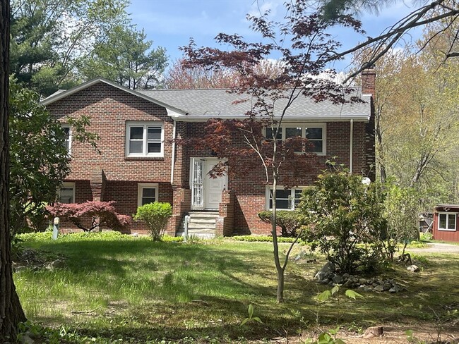
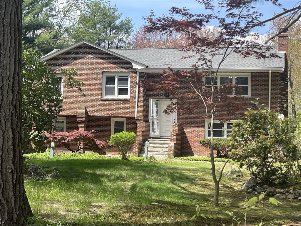
465 Hartford St
Westwood, MA 02090
Today
Favorites
617-610-4057
-
Bedrooms
3
-
Bathrooms
2
-
Square Feet
2,200 sq ft
-
Available
Available Now
Highlights
- Deck
- Property is near public transit
- 2 Fireplaces
- Jogging Path
- Enclosed patio or porch
- No Cooling
465 Hartford St

Favorites
About This Home
$4,500 deposit,
Available Now
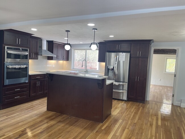
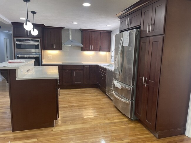
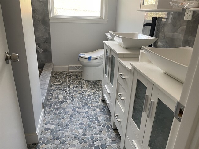
Generously spacious single home residence in downtown Westwood. Newly updated with a new kitchen,bathroom,and brand new appliances. This home enjoys abundant natural light and a layout for easy living and entertaining. The living room’s fireplace provides comfort & warmth in the wintertime and offers a welcoming open concept living connected to a finished sunroom and a deck. The finished basement offers a 2nd living space with a bathroom and a bonus room. The property includes polished hardwood floors,quartz countertops and stainless-steel appliances,a washer and dryer,an enclosed patio for good relaxation,and outdoor cooking. MLS# 73370047
465 Hartford St is a house located in Norfolk County and the 02090 ZIP Code. This area is served by the Westwood attendance zone.
* Price shown is base rent and may not include non-optional fees and utilities.
Price, availability, fees, and any applicable rent special are subject to change without notice.
* Square footage definitions vary. Displayed square footage is approximate.
Home Details
Home Type
Single Family Detached Home
Accessible Home Design
Entry on the 1st floor
Bedrooms and Bathrooms
2 Full Bathrooms
3 Bedrooms
Interior Spaces
2 Fireplaces
2,200 Sq Ft Home
Kitchen
Range
Oven
Dishwasher
Laundry
Dryer
Washer
Listing and Financial Details
Security Deposit $4,500
Assessor Parcel Number M:019 B:000 L:019,300873
Rent includes water
Location
Property is near public transit
Property is near schools
Lot Details
1 Acre Lot
Outdoor Features
Deck
Enclosed patio or porch
Parking
1 Car Garage
Utilities
No Cooling
Community Details
Amenities
Shops
Overview
No Home Owners Association
Pet Policy
No Pets Allowed
Recreation
Jogging Path
Fees and Policies
The fees below are based on community-supplied data and may exclude additional fees and utilities.
Contact
- Listed by Sara Hamadane | Conway - Bridgewater
- Phone Number
-
Source
 MLS Property Information Network
The property listing data and information set forth herein were provided to MLS Property Information Network, Inc. from third party sources, including sellers, lessors and public records, and were compiled by MLS Property Information Network, Inc. The property listing data and information are for the personal, non-commercial use of consumers having a good faith interest in purchasing or leasing listed properties of the type displayed to them and may not be used for any purpose other than to identify prospective properties which such consumers may have a good faith interest in purchasing or leasing. MLS Property Information Network, Inc. and its subscribers disclaim any and all representations and warranties as to the accuracy of the property listing data and information set forth herein. All properties are subject to prior sale, change or withdrawal. Copyright © 2025 MLS Property Information Network, Inc. All rights reserved.
Location
Get Directions
Amenities
- Dishwasher
- Range
- Refrigerator
- Patio
- Deck
Approximately 25 miles from Boston, the town of Westwood offers residents the simplicity of suburban living and the closeness to metropolitan nightlife and attractions. CNN/Money and Money Magazine named Westwood in their “100 Best Places to Live” in 2005.
Expansive greenspaces like Rice Reservation, Mulvehill- and Grimm Conservation, and Pheasant Hill makeup this unique, charming Norfolk County town. Ready for some fun-in-the-sun? Hale Reservation’s North Beach is a prime spot for sun and swim. Shopping and dining destinations include University Station, and college campuses and universities are easily accessible by I-95 and rail services provided by Massachusetts Bay Transportation Authority (MBTA).
Learn more about living in Westwood
Education
| Colleges & Universities | Distance | ||
|---|---|---|---|
| Colleges & Universities | Distance | ||
| Drive: | 16 min | 7.5 mi | |
| Drive: | 18 min | 8.9 mi | |
| Drive: | 21 min | 9.8 mi | |
| Drive: | 18 min | 10.5 mi |
465 Hartford St is within 16 minutes or 7.5 miles from Babson College. It is also near Curry College and Wellesley College.
Schools


Public Elementary School
Grades PK-5
502 Students
Nearby
Public Elementary School
Grades K-5
287 Students
Attendance Zone
Public Middle School
Grades 6-8
661 Students
Attendance Zone
Public High School
Grades 9-12
902 Students
Attendance Zone
Private Elementary & Middle School
Grades PK-8
324 Students
Nearby
Private Middle & High School
Grades 7-12
965 Students
Nearby
School data provided by
 The GreatSchools Rating helps parents compare schools within a state based on a variety of school quality indicators and provides a helpful picture of how effectively each school serves all of its students. Ratings are on a scale of 1 (below average) to 10 (above average) and can include test scores, college readiness, academic progress, advanced courses, equity, discipline and attendance data. We also advise parents to visit schools, consider other information on school performance and programs, and consider family needs as part of the school selection process.
View GreatSchools Rating Methodology
Data provided by GreatSchools.org © 2025. All rights reserved.
View GreatSchools Rating Methodology
Data provided by GreatSchools.org © 2025. All rights reserved.
Transportation options available in Westwood include Newton Highlands Station, located 9.7 miles from 465 Hartford St. 465 Hartford St is near General Edward Lawrence Logan International, located 19.2 miles or 36 minutes away, and Worcester Regional, located 49.2 miles or 71 minutes away.
| Transit / Subway | Distance | ||
|---|---|---|---|
| Transit / Subway | Distance | ||
|
|
Drive: | 17 min | 9.7 mi |
|
|
Drive: | 17 min | 10.2 mi |
|
|
Drive: | 18 min | 10.4 mi |
|
|
Drive: | 19 min | 10.8 mi |
|
|
Drive: | 18 min | 11.1 mi |
| Commuter Rail | Distance | ||
|---|---|---|---|
| Commuter Rail | Distance | ||
|
|
Drive: | 8 min | 3.6 mi |
|
|
Drive: | 9 min | 3.9 mi |
|
|
Drive: | 8 min | 4.0 mi |
|
|
Drive: | 10 min | 5.5 mi |
|
|
Drive: | 12 min | 5.8 mi |
| Airports | Distance | ||
|---|---|---|---|
| Airports | Distance | ||
|
General Edward Lawrence Logan International
|
Drive: | 36 min | 19.2 mi |
|
Worcester Regional
|
Drive: | 71 min | 49.2 mi |
Time and distance from 465 Hartford St.
| Shopping Centers | Distance | ||
|---|---|---|---|
| Shopping Centers | Distance | ||
| Drive: | 7 min | 3.1 mi | |
| Drive: | 8 min | 3.6 mi | |
| Drive: | 8 min | 3.6 mi |
465 Hartford St has 3 shopping centers within 3.6 miles, which is about a 8-minute drive. The miles and minutes will be for the farthest away property.
| Parks and Recreation | Distance | ||
|---|---|---|---|
| Parks and Recreation | Distance | ||
|
Lookout Farm
|
Drive: | 14 min | 6.1 mi |
|
Horticultural Society at Elm Bank
|
Drive: | 17 min | 6.7 mi |
|
Natick Community Organic Farm
|
Drive: | 18 min | 7.4 mi |
|
Weezie's Garden for Children
|
Drive: | 21 min | 7.9 mi |
|
Elm Bank Reservation
|
Drive: | 21 min | 7.9 mi |
465 Hartford St has 5 parks within 7.9 miles, including Lookout Farm, Horticultural Society at Elm Bank, and Elm Bank Reservation.
| Hospitals | Distance | ||
|---|---|---|---|
| Hospitals | Distance | ||
| Drive: | 4 min | 2.0 mi | |
| Drive: | 8 min | 3.7 mi | |
| Drive: | 10 min | 5.4 mi |
465 Hartford St has 3 hospitals within 5.4 miles, the nearest is Westwood Pembroke Health Systems which is 2.0 miles away and a 4 minute drive.
| Military Bases | Distance | ||
|---|---|---|---|
| Military Bases | Distance | ||
| Drive: | 23 min | 9.5 mi |
465 Hartford St is 9.5 miles and a 23 minute drive from US Military Reservation.
You May Also Like
Similar Rentals Nearby


What Are Walk Score®, Transit Score®, and Bike Score® Ratings?
Walk Score® measures the walkability of any address. Transit Score® measures access to public transit. Bike Score® measures the bikeability of any address.
What is a Sound Score Rating?
A Sound Score Rating aggregates noise caused by vehicle traffic, airplane traffic and local sources
465 Hartford St
Westwood, MA 02090