
$3,850 / Month
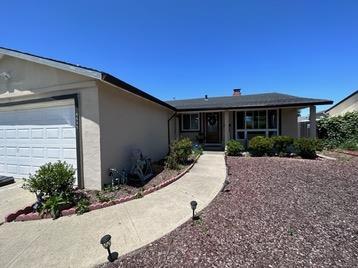
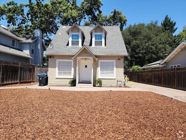
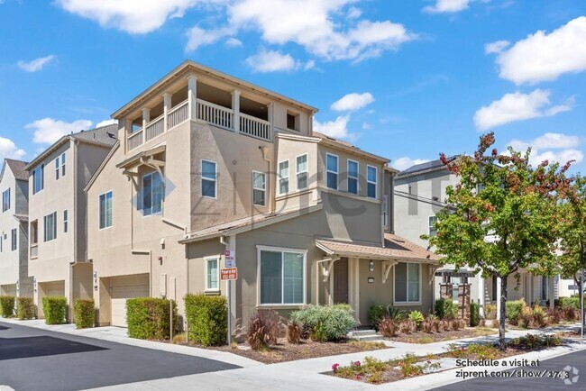
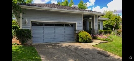
4645 Bianca Dr
Fremont, CA 94536
2 Weeks Ago
Favorites
4645 Bianca Dr

Favorites
Check Back Soon for Upcoming Availability
| Beds | Baths | Average SF |
|---|---|---|
| 3 Bedrooms 3 Bedrooms 3 Br | 2 Baths 2 Baths 2 Ba | 1,450 SF |
About This Property
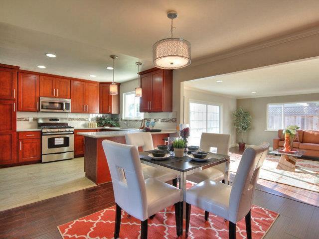
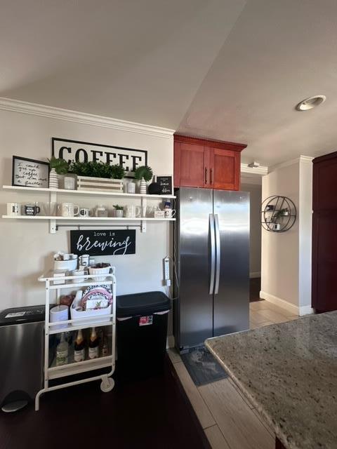
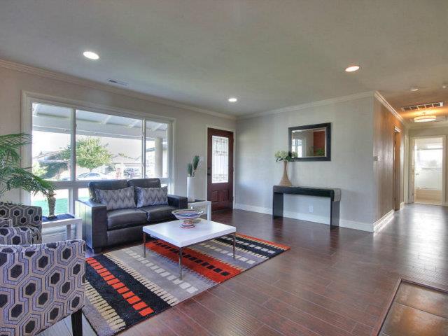
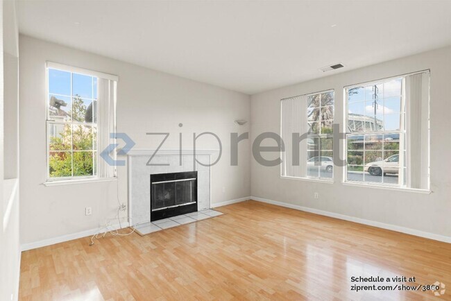
### email only please.. please do not call.### Thx Beautiful single-family house in outstanding north Fremont, 1450 sq. ft. Interior living space with 3B2B. Bright and Open floor plan with large family room. hardwood floor, tiled bathrooms, recessed lighting. Modern kitchen with fine cabinetry that offers ample storage space; granite countertop, stainless steel appliances. Attached two car garage. Low maintenance landscaping with mature fruit trees, mulch in front yard and paver in backyard. Great Fremont schools district. Close to HW 880, Dumbarton Bridge & Meta Campus; Nearby shuttles to Meta, Google, Menlo Park Labs, Stanford campus; Close to grocery stores and parks Home available on June 21st, 2023 Lease Terms: - One year lease - Security deposit: One month rent - Tenants to pay for ALL Utilities: Gas, Electricity, Internet, Water, Garbage Pick Up. - Tenants to carry renter's insurance Requirement: - Application with credit check - Good credit - Proof of Stable income - Good rental history - Smoke free
4645 Bianca Dr is a house located in Alameda County and the 94536 ZIP Code. This area is served by the Fremont Unified attendance zone.
Location
Get Directions
Sandwiched between Interstate 880 and Fremont Boulevard, the Cabrillo neighborhood gives its residents access to main roads, schools and shopping, while upholding Fremont’s multicultural reputation. Just a block away from the bustling center of the Centerville District, Cabrillo and its residents appreciate quiet East Bay Area living. Locals can drive or take the BART train to San Francisco, less than an hour away, or stick around in Fremont for a night out in Centerville.
In Cabrillo, travelers can live in small and large houses alike while learning about the history and culture of one of the Bay Area’s most hidden gems. Enjoy living in one of the safest cities in the United States while being close to all the urban attractions San Francisco has to offer.
Learn more about living in CabrilloBelow are rent ranges for similar nearby apartments
Education
| Colleges & Universities | Distance | ||
|---|---|---|---|
| Colleges & Universities | Distance | ||
| Drive: | 8 min | 4.4 mi | |
| Drive: | 14 min | 9.1 mi | |
| Drive: | 16 min | 9.7 mi | |
| Drive: | 15 min | 9.9 mi |
4645 Bianca Dr is within 8 minutes or 4.4 miles from Ohlone College, Newark. It is also near Ohlone College, Fremont Campus and Chabot College.
Schools


Public Elementary School
Grades K-5
343 Students
Nearby
Public Elementary School
Grades 1-5
709 Students
Attendance Zone
Public Middle School
Grades 6-8
1,302 Students
Attendance Zone
Public High School
Grades 9-12
2,501 Students
Attendance Zone
Private Elementary, Middle & High School
Grades PK-12
691 Students
Nearby
Private Elementary & Middle School
Grades K-8
45 Students
Nearby
School data provided by
 The GreatSchools Rating helps parents compare schools within a state based on a variety of school quality indicators and provides a helpful picture of how effectively each school serves all of its students. Ratings are on a scale of 1 (below average) to 10 (above average) and can include test scores, college readiness, academic progress, advanced courses, equity, discipline and attendance data. We also advise parents to visit schools, consider other information on school performance and programs, and consider family needs as part of the school selection process.
View GreatSchools Rating Methodology
View GreatSchools Rating Methodology
Transportation options available in Fremont include Union City Station, located 3.1 miles from 4645 Bianca Dr. 4645 Bianca Dr is near Metro Oakland International, located 17.8 miles or 24 minutes away, and Norman Y Mineta San Jose International, located 19.2 miles or 25 minutes away.
| Transit / Subway | Distance | ||
|---|---|---|---|
| Transit / Subway | Distance | ||
|
|
Drive: | 7 min | 3.1 mi |
|
|
Drive: | 9 min | 4.2 mi |
|
|
Drive: | 12 min | 7.8 mi |
|
|
Drive: | 13 min | 8.0 mi |
|
|
Drive: | 14 min | 9.3 mi |
| Commuter Rail | Distance | ||
|---|---|---|---|
| Commuter Rail | Distance | ||
| Drive: | 5 min | 2.1 mi | |
| Drive: | 14 min | 9.6 mi | |
|
|
Drive: | 14 min | 9.6 mi |
| Drive: | 23 min | 14.7 mi | |
| Drive: | 29 min | 18.3 mi |
| Airports | Distance | ||
|---|---|---|---|
| Airports | Distance | ||
|
Metro Oakland International
|
Drive: | 24 min | 17.8 mi |
|
Norman Y Mineta San Jose International
|
Drive: | 25 min | 19.2 mi |
Time and distance from 4645 Bianca Dr.
| Shopping Centers | Distance | ||
|---|---|---|---|
| Shopping Centers | Distance | ||
| Walk: | 20 min | 1.1 mi | |
| Drive: | 3 min | 1.2 mi | |
| Drive: | 3 min | 1.2 mi |
4645 Bianca Dr has 3 shopping centers within 1.2 miles, which is about a 3-minute walk. The miles and minutes will be for the farthest away property.
| Parks and Recreation | Distance | ||
|---|---|---|---|
| Parks and Recreation | Distance | ||
|
Quarry Lakes Regional Recreation Area
|
Drive: | 4 min | 1.7 mi |
|
Alameda Creek Regional Trail
|
Drive: | 5 min | 2.0 mi |
|
Ardenwood Historic Farm
|
Drive: | 6 min | 2.8 mi |
|
Niles Canyon Railway
|
Drive: | 9 min | 4.7 mi |
|
Niles Community Park
|
Drive: | 11 min | 4.8 mi |
4645 Bianca Dr has 5 parks within 4.8 miles, including Quarry Lakes Regional Recreation Area, Alameda Creek Regional Trail, and Ardenwood Historic Farm.
| Hospitals | Distance | ||
|---|---|---|---|
| Hospitals | Distance | ||
| Drive: | 8 min | 4.1 mi | |
| Drive: | 8 min | 4.2 mi | |
| Drive: | 11 min | 6.8 mi |
4645 Bianca Dr has 3 hospitals within 6.8 miles, the nearest is Kaiser Foundation Hospital - Fremont which is 4.1 miles away and a 8 minute drive.
| Military Bases | Distance | ||
|---|---|---|---|
| Military Bases | Distance | ||
| Drive: | 28 min | 18.6 mi |
4645 Bianca Dr is 18.6 miles and a 28 minute drive from Ames Research Center.
You May Also Like
Similar Rentals Nearby

What Are Walk Score®, Transit Score®, and Bike Score® Ratings?
Walk Score® measures the walkability of any address. Transit Score® measures access to public transit. Bike Score® measures the bikeability of any address.
What is a Sound Score Rating?
A Sound Score Rating aggregates noise caused by vehicle traffic, airplane traffic and local sources

4645 Bianca Dr
Fremont, CA 94536