1 / 23


| Beds | Baths | Average SF |
|---|---|---|
| 3 Bedrooms 3 Bedrooms 3 Br | 2 Baths 2 Baths 2 Ba | 1,137 SF |
The fees below are based on community-supplied data and may exclude additional fees and utilities.
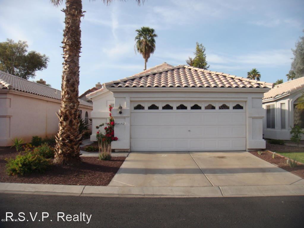
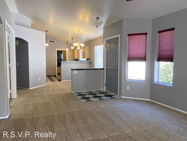
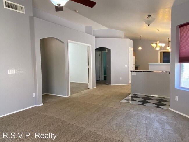
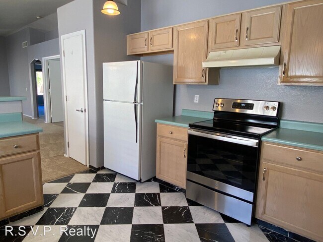
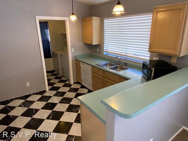
x3 - Chandler 2 Bed + Den - 2 Bath Single Story - R.S.V.P. Realty Available to Move in April 10, 2023 1,137 SqFt - 2 Bed/2 Bath + Den- (Den can be used as a 3rd Bedroom, has no closet) Well Utilized Square Footage with a Split Floor Plan - Great Room - Vaulted Ceilings, Ceiling Fans - Eat-In Kitchen with Breakfast Bar - Inside Laundry Room - Carpet, Stone and Tile - Automatic Yard Water System, Covered Patio - 2 Car Garage, w/Electric Opener - North/South Facing. INCLUDES: Range/Oven, Dishwasher, Disposal, Refrigerator, Washer and Dryer Hook-Ups Only. DIRECTIONS: RAY & McCLINTOCK: From McClintock go West on Ray, South on Desert Breeze Blvd, West on Joshua, North on Stanley, West on Del Rio to Property. UTILITIES: SRP, City of Chandler Water SCHOOLS: Brisas, Aprende, Corona Del Sol High $1,995.00 Rent + 1.5% Chandler City Tax Per Month +$25.00 Utility & Maintenance Reduction Fee M+ 1.5% Chandler City Tax Per Month (not included in rent) $1,995.00 Security Deposit +$550.00 Non-Refundable Cleaning Fee $50.00 Application Fee Per Person over the Age of 18. R.S.V.P. Realty (Pictures are from a previous listing) (RLNE2326758) Appliances: Dishwasher, Refrigerator, Range, Oven, Garbage Disposal, Washer & Dryer Hookup, Microwave.
4632 W Del Rio St is a house located in Maricopa County and the 85226 ZIP Code. This area is served by the Kyrene Elementary attendance zone.
Situated about four miles west of Downtown Chandler, West Chandler is a scenic suburb brimming with recreation and retail. West Chandler residents enjoy access to an array of local parks, including Desert Breeze Park, Nozomi Park, and Hanger Park, as well as close proximity to the sprawling South Mountain Park.
Retail options in West Chandler provide a host of modern delights and everyday conveniences, with numerous shopping centers and plazas strewn throughout the area in addition to the upscale Chandler Fashion Center. West Chandler is also convenient to the popular Lone Butte Casino. Getting around from West Chandler is easy with access to the Santan Freeway, Maricopa Freeway, and the Price Freeway.
Learn more about living in West Chandler| Beds | Average Size | Lowest | Typical | Premium |
|---|---|---|---|---|
| Studio Studio Studio | 384 Sq Ft | $1,460 | $1,846 | $2,854 |
| 1 Bed 1 Bed 1 Bed | 743 Sq Ft | $1,168 | $1,911 | $9,277 |
| 2 Beds 2 Beds 2 Beds | 1084 Sq Ft | $1,331 | $2,403 | $11,518 |
| 3 Beds 3 Beds 3 Beds | 1408 Sq Ft | $1,766 | $3,033 | $14,468 |
| 4 Beds 4 Beds 4 Beds | 2373 Sq Ft | $899 | $3,690 | $10,500 |
| Colleges & Universities | Distance | ||
|---|---|---|---|
| Colleges & Universities | Distance | ||
| Drive: | 15 min | 8.0 mi | |
| Drive: | 17 min | 8.6 mi | |
| Drive: | 17 min | 8.6 mi | |
| Drive: | 15 min | 9.0 mi |


Transportation options available in Chandler include Rural/Apache, located 7.3 miles from 4632 W Del Rio St. 4632 W Del Rio St is near Phoenix Sky Harbor International, located 13.7 miles or 22 minutes away, and Phoenix-Mesa Gateway, located 18.3 miles or 28 minutes away.
| Transit / Subway | Distance | ||
|---|---|---|---|
| Transit / Subway | Distance | ||
|
|
Drive: | 14 min | 7.3 mi |
|
|
Drive: | 15 min | 7.4 mi |
|
|
Drive: | 15 min | 7.6 mi |
|
|
Drive: | 16 min | 8.1 mi |
|
|
Drive: | 16 min | 9.6 mi |
| Commuter Rail | Distance | ||
|---|---|---|---|
| Commuter Rail | Distance | ||
|
|
Drive: | 31 min | 21.5 mi |
| Airports | Distance | ||
|---|---|---|---|
| Airports | Distance | ||
|
Phoenix Sky Harbor International
|
Drive: | 22 min | 13.7 mi |
|
Phoenix-Mesa Gateway
|
Drive: | 28 min | 18.3 mi |
Time and distance from 4632 W Del Rio St.
| Shopping Centers | Distance | ||
|---|---|---|---|
| Shopping Centers | Distance | ||
| Walk: | 7 min | 0.4 mi | |
| Walk: | 9 min | 0.5 mi | |
| Walk: | 10 min | 0.5 mi |
| Parks and Recreation | Distance | ||
|---|---|---|---|
| Parks and Recreation | Distance | ||
|
Pecos Park
|
Drive: | 10 min | 4.9 mi |
|
South Mountain Park
|
Drive: | 15 min | 6.9 mi |
|
ASU Center for Meteorite Studies
|
Drive: | 17 min | 7.8 mi |
|
Desert Arboretum Park
|
Drive: | 17 min | 8.3 mi |
|
i.d.e.a. Museum
|
Drive: | 19 min | 11.7 mi |
| Hospitals | Distance | ||
|---|---|---|---|
| Hospitals | Distance | ||
| Drive: | 6 min | 3.1 mi | |
| Drive: | 8 min | 4.2 mi | |
| Drive: | 8 min | 4.2 mi |
| Military Bases | Distance | ||
|---|---|---|---|
| Military Bases | Distance | ||
| Drive: | 22 min | 14.4 mi | |
| Drive: | 51 min | 38.9 mi | |
| Drive: | 100 min | 80.3 mi |
What Are Walk Score®, Transit Score®, and Bike Score® Ratings?
Walk Score® measures the walkability of any address. Transit Score® measures access to public transit. Bike Score® measures the bikeability of any address.
What is a Sound Score Rating?
A Sound Score Rating aggregates noise caused by vehicle traffic, airplane traffic and local sources

4632 W Del Rio St
Chandler, AZ 85226


