

$2,150
/ Month
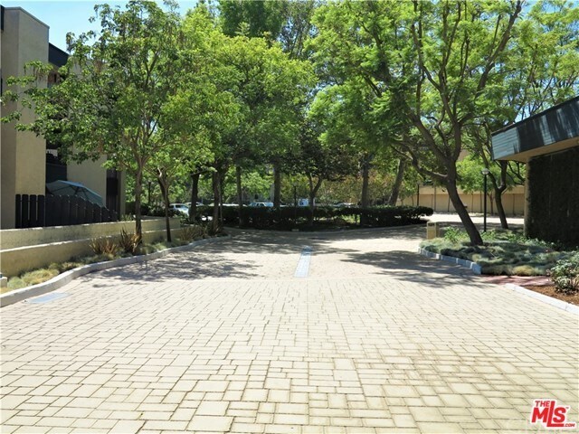
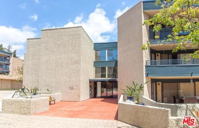
4589 Via Marisol Unit 160
Los Angeles, CA 90042
2 Weeks Ago
|
Edit
Favorites
4589 Via Marisol Unit 160

Favorites
Check Back Soon for Upcoming Availability
| Beds | Baths | Average SF |
|---|---|---|
| 2 Bedrooms 2 Bedrooms 2 Br | 1 Bath 1 Bath 1 Ba | — |
About This Property
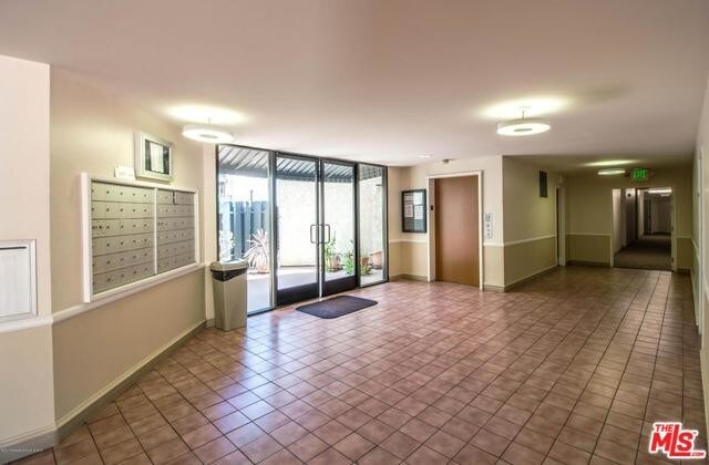
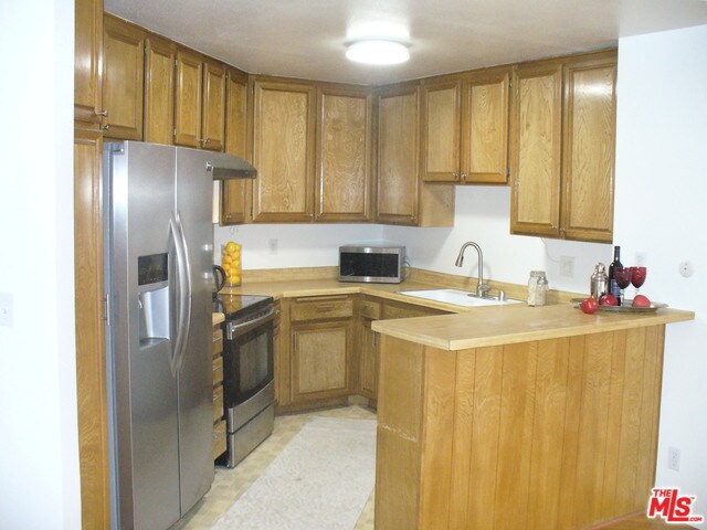
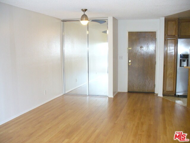
Sleek and bright 2 bedrm 1 bath condo in desirable Monterey Hills of Los Angles is beyond immaculate & move in ready. Fresh paints, wood-like floors add to the comfort of this 1st floor unit which offers an open floor plan, lots of natural light, and wall of glass allowing access to a huge patio from most rooms--suitable for relaxation and creative inspiration. To the chefs delight the kitchen includes high grade stainless steel appliances-range/hood, refrigerator, dishwasher and breakfast bar for morning coffee. Dining area w/mirror closets and the living room flow seamlessly to outdoor living (dual pane windows). The master bedroom is complemented by wall to wall closet, the 2nd bedrm enjoys mirror closets. Ample storage can be found in the hall and bathrm. Washer and dryer are included. Eaton Crest complex amenities: 2 assigned parking spaces in secure garage, pool, spa and club house in limited access building w/security cameras. No pets. See addendum. Close prox to frwys DTLA Pas
4589 Via Marisol is a condo located in Los Angeles County and the 90042 ZIP Code. This area is served by the Los Angeles Unified attendance zone.
Location
Get Directions
A quiet suburb outside of Los Angeles, Monterey Hills is known for its rolling hills, winding residential streets, and elevated city views. Check out Elephant Hill, a popular place to bike or hike that offers beautiful views of the neighborhood. Herman Park is nestled along Highway 110 in the north end of the neighborhood, offering tennis courts, playgrounds, and a dog park. And for more outdoor recreation, visit the biking paths and hiking trails at Ernest E. Debs Regional Park, bordering Monterey Hills.
Monterey Hills is a more secluded part of Northeast Los Angeles with larger lots, single-family homes, and tree-lined streets. However, if you cross over Highway 110, you’ll find theatres, restaurants, services, and more. Monterey Hills is located just seven miles northeast of Downtown Los Angeles and eight miles east of major attractions such as Griffith Park, the Los Angeles Zoo, the Greek Theatre, and Glendale Galleria.
Learn more about living in Monterey HillsBelow are rent ranges for similar nearby apartments
| Beds | Average Size | Lowest | Typical | Premium |
|---|---|---|---|---|
| Studio Studio Studio | 440 Sq Ft | $1,739 | $2,044 | $2,349 |
| 1 Bed 1 Bed 1 Bed | 628 Sq Ft | $1,700 | $2,222 | $2,849 |
| 2 Beds 2 Beds 2 Beds | 985-995 Sq Ft | $1,647 | $3,034 | $5,184 |
| 3 Beds 3 Beds 3 Beds | 1234 Sq Ft | $1,901 | $3,746 | $7,900 |
| 4 Beds 4 Beds 4 Beds | 1665 Sq Ft | $1,060 | $3,769 | $8,000 |
Education
| Colleges & Universities | Distance | ||
|---|---|---|---|
| Colleges & Universities | Distance | ||
| Drive: | 9 min | 3.7 mi | |
| Drive: | 8 min | 3.9 mi | |
| Drive: | 7 min | 4.1 mi | |
| Drive: | 11 min | 4.2 mi |
4589 Via Marisol Unit 160 is within 9 minutes or 3.7 miles from Occidental College. It is also near Cal State Los Angeles and USC, Health Sciences Campus.
Schools


Charter Elementary School
Grades K-5
75 Students
Nearby
Public Elementary School
Grades K-5
181 Students
Attendance Zone
Public Middle & High School
Grades 6-12
1,389 Students
Attendance Zone
Public Middle School
Grades 6-8
904 Students
Attendance Zone
Private Elementary School
Grades PK-5
131 Students
Nearby
Private Elementary, Middle & High School
Grades K-12
93 Students
Nearby
Private Elementary & Middle School
Grades K-8
Nearby
School data provided by
 The GreatSchools Rating helps parents compare schools within a state based on a variety of school quality indicators and provides a helpful picture of how effectively each school serves all of its students. Ratings are on a scale of 1 (below average) to 10 (above average) and can include test scores, college readiness, academic progress, advanced courses, equity, discipline and attendance data. We also advise parents to visit schools, consider other information on school performance and programs, and consider family needs as part of the school selection process.
View GreatSchools Rating Methodology
Data provided by GreatSchools.org © 2025. All rights reserved.
View GreatSchools Rating Methodology
Data provided by GreatSchools.org © 2025. All rights reserved.
Transportation options available in Los Angeles include Highland Park Station, located 1.5 miles from 4589 Via Marisol Unit 160. 4589 Via Marisol Unit 160 is near Bob Hope, located 18.0 miles or 26 minutes away, and Los Angeles International, located 21.0 miles or 34 minutes away.
| Transit / Subway | Distance | ||
|---|---|---|---|
| Transit / Subway | Distance | ||
|
|
Drive: | 4 min | 1.5 mi |
|
|
Drive: | 6 min | 2.7 mi |
|
|
Drive: | 6 min | 3.0 mi |
|
|
Drive: | 6 min | 3.1 mi |
|
|
Drive: | 7 min | 3.7 mi |
| Commuter Rail | Distance | ||
|---|---|---|---|
| Commuter Rail | Distance | ||
|
|
Drive: | 13 min | 5.4 mi |
|
|
Drive: | 11 min | 5.9 mi |
|
|
Drive: | 12 min | 7.2 mi |
| Drive: | 15 min | 10.0 mi | |
|
|
Drive: | 21 min | 10.2 mi |
| Airports | Distance | ||
|---|---|---|---|
| Airports | Distance | ||
|
Bob Hope
|
Drive: | 26 min | 18.0 mi |
|
Los Angeles International
|
Drive: | 34 min | 21.0 mi |
Time and distance from 4589 Via Marisol Unit 160.
| Shopping Centers | Distance | ||
|---|---|---|---|
| Shopping Centers | Distance | ||
| Drive: | 3 min | 1.3 mi | |
| Drive: | 4 min | 1.8 mi | |
| Drive: | 4 min | 2.0 mi |
4589 Via Marisol Unit 160 has 3 shopping centers within 2.0 miles, which is about a 4-minute drive. The miles and minutes will be for the farthest away property.
| Parks and Recreation | Distance | ||
|---|---|---|---|
| Parks and Recreation | Distance | ||
|
Audubon Center at Debs Park
|
Drive: | 4 min | 2.0 mi |
|
Chavez Ravine Arboretum
|
Drive: | 10 min | 5.7 mi |
|
Elysian Park
|
Drive: | 13 min | 5.7 mi |
|
Elyria Canyon Park
|
Drive: | 11 min | 6.0 mi |
|
Marsh Park
|
Drive: | 12 min | 6.3 mi |
4589 Via Marisol Unit 160 has 5 parks within 6.3 miles, including Audubon Center at Debs Park, Elyria Canyon Park, and Elysian Park.
| Hospitals | Distance | ||
|---|---|---|---|
| Hospitals | Distance | ||
| Drive: | 7 min | 3.6 mi | |
| Drive: | 9 min | 3.7 mi | |
| Drive: | 7 min | 4.5 mi |
4589 Via Marisol Unit 160 has 3 hospitals within 4.5 miles, the nearest is Keck Hospital of USC which is 3.6 miles away and a 7 minute drive.
| Military Bases | Distance | ||
|---|---|---|---|
| Military Bases | Distance | ||
| Drive: | 31 min | 22.6 mi | |
| Drive: | 42 min | 27.1 mi |
4589 Via Marisol Unit 160 is 22.6 miles from Los Angeles Air Force Base, and is convenient to other military bases, including Los Alamitos Army Airfield.
You May Also Like
Similar Rentals Nearby
-
-

-

-

-
-
-
1 / 13

-
1 / 13

-
1 / 25

-
1 / 17


What Are Walk Score®, Transit Score®, and Bike Score® Ratings?
Walk Score® measures the walkability of any address. Transit Score® measures access to public transit. Bike Score® measures the bikeability of any address.
What is a Sound Score Rating?
A Sound Score Rating aggregates noise caused by vehicle traffic, airplane traffic and local sources
4589 Via Marisol
Los Angeles, CA 90042