
Hudson Park Community
1 Alexander St,
Yonkers, NY 10701
$2,250 - $3,500
1-2 Beds

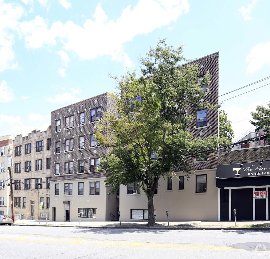

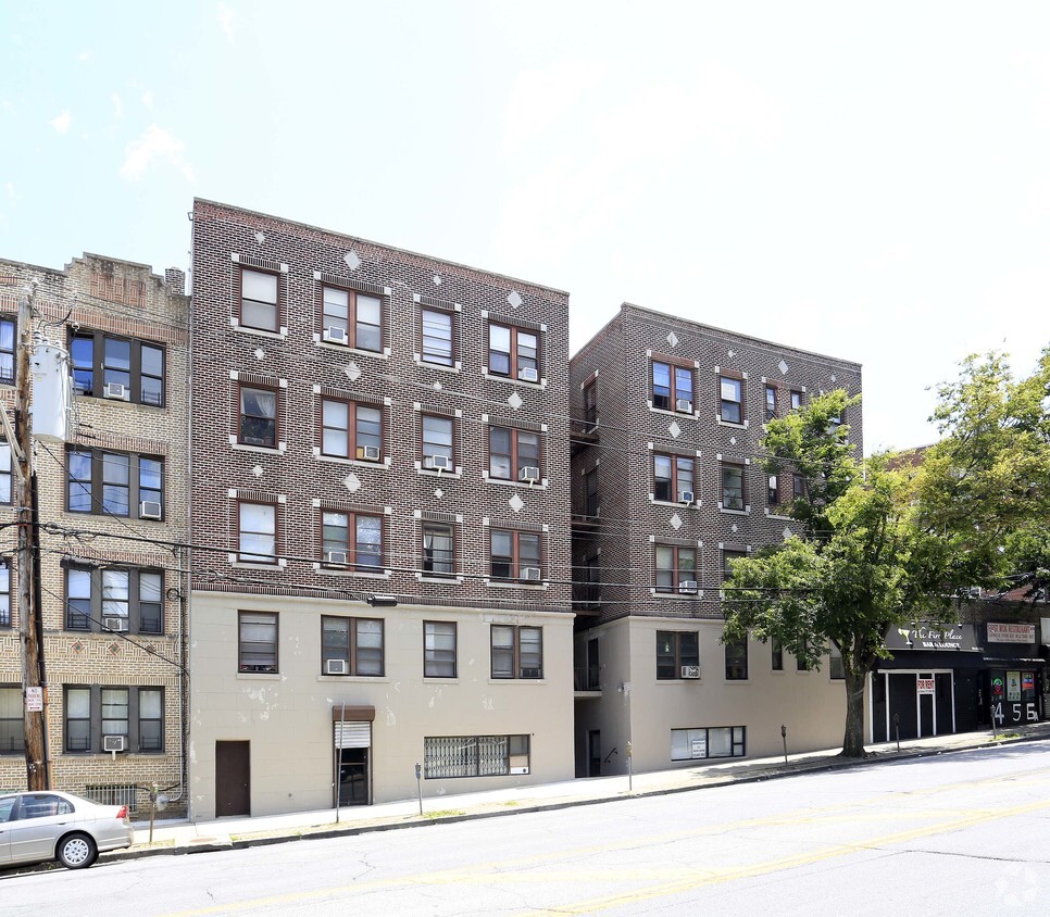
Explore 454 Riverdale Ave. In the 10705 Zip code of Yonkers on Riverdale Ave, residents have easy connection to a variety of entertainment options found in the surrounding area. The professional leasing staff is waiting to show you all that this community has to offer. Come by to see the current floorplan options. Stop by 454 Riverdale Ave today.
454 Riverdale Ave is an apartment community located in Westchester County and the 10705 ZIP Code. This area is served by the Yonkers City School District attendance zone.
Air Conditioning
Tub/Shower
Heating
Kitchen
Ludlow is a scenic neighborhood nestled alongside the eastern banks of the Hudson River in southwest Yonkers. Residents in Ludlow enjoy the best of urban and suburban lifestyles, from the neighborhood’s tree-lined residential streets to the vibrant commercial offerings on Broadway.
Ludlow provides a diverse range of rental options, from longstanding apartments in red-brick buildings to charming houses brimming with historic character. Many of the community’s rentals lie within walking distance of shops and restaurants on Broadway to the east as well as picturesque views of the Hudson River to the west. Yonkers’ Main Street neighbors Ludlow to the north, while Ludlow Station lies at the heart of the community, connecting residents to Grand Central Station via the Hudson Line within 30 minutes.
Learn more about living in LudlowCompare neighborhood and city base rent averages by bedroom.
| Ludlow | Yonkers, NY | |
|---|---|---|
| Studio | $1,320 | $1,990 |
| 1 Bedroom | $1,541 | $2,308 |
| 2 Bedrooms | $2,094 | $3,051 |
| 3 Bedrooms | $1,470 | $3,294 |
| Colleges & Universities | Distance | ||
|---|---|---|---|
| Colleges & Universities | Distance | ||
| Drive: | 4 min | 2.2 mi | |
| Drive: | 8 min | 4.1 mi | |
| Drive: | 9 min | 4.8 mi | |
| Drive: | 10 min | 5.2 mi |


Transportation options available in Yonkers include Van Cortlandt Park-242 Street, located 2.1 miles from 454 Riverdale Ave. 454 Riverdale Ave is near LaGuardia, located 14.5 miles or 26 minutes away, and Westchester County, located 23.0 miles or 32 minutes away.
| Transit / Subway | Distance | ||
|---|---|---|---|
| Transit / Subway | Distance | ||
|
|
Drive: | 4 min | 2.1 mi |
|
|
Drive: | 5 min | 2.5 mi |
|
|
Drive: | 5 min | 3.0 mi |
|
|
Drive: | 5 min | 3.5 mi |
|
|
Drive: | 6 min | 3.8 mi |
| Commuter Rail | Distance | ||
|---|---|---|---|
| Commuter Rail | Distance | ||
|
|
Walk: | 14 min | 0.8 mi |
|
|
Drive: | 4 min | 1.4 mi |
|
|
Drive: | 3 min | 1.6 mi |
|
|
Drive: | 8 min | 3.1 mi |
|
|
Drive: | 8 min | 3.6 mi |
| Airports | Distance | ||
|---|---|---|---|
| Airports | Distance | ||
|
LaGuardia
|
Drive: | 26 min | 14.5 mi |
|
Westchester County
|
Drive: | 32 min | 23.0 mi |
Scores provided by
Traffic
-Airport
-Businesses
-Scores provided by
HowLoud What is a Sound Score Rating? A Sound Score Rating aggregates noise caused by vehicle traffic, airplane traffic and local sources. How It WorksTime and distance from 454 Riverdale Ave.
| Shopping Centers | Distance | ||
|---|---|---|---|
| Shopping Centers | Distance | ||
| Walk: | 13 min | 0.7 mi | |
| Drive: | 2 min | 1.4 mi | |
| Drive: | 5 min | 2.2 mi |
| Parks and Recreation | Distance | ||
|---|---|---|---|
| Parks and Recreation | Distance | ||
|
Wave Hill
|
Drive: | 5 min | 1.6 mi |
|
Beczak Environmental Education Center
|
Drive: | 3 min | 1.7 mi |
|
Riverdale Park
|
Drive: | 5 min | 2.0 mi |
|
Van Cortlandt Park
|
Drive: | 6 min | 4.2 mi |
|
Tenafly Nature Center
|
Drive: | 20 min | 12.2 mi |
| Hospitals | Distance | ||
|---|---|---|---|
| Hospitals | Distance | ||
| Drive: | 2 min | 1.2 mi | |
| Drive: | 5 min | 3.7 mi | |
| Drive: | 6 min | 3.9 mi |
| Military Bases | Distance | ||
|---|---|---|---|
| Military Bases | Distance | ||
| Drive: | 27 min | 14.4 mi | |
| Drive: | 34 min | 17.3 mi | |
| Drive: | 41 min | 26.8 mi |
What Are Walk Score®, Transit Score®, and Bike Score® Ratings?
Walk Score® measures the walkability of any address. Transit Score® measures access to public transit. Bike Score® measures the bikeability of any address.
What is a Sound Score Rating?
A Sound Score Rating aggregates noise caused by vehicle traffic, airplane traffic and local sources.
454 Riverdale Ave
Yonkers, NY 10705


