
Presidential Towers
555 W Madison St,
Chicago, IL 60661
$1,659 - $6,667
Studio - 2 Beds


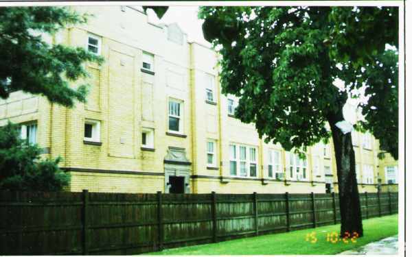
Find your new home at 4538-4542 N Kenneth Ave. Based in the 60630 area of Chicago on N. Kenneth Ave, local residents have a quick connection to great attractions in the surrounding area. Be sure to see the available floorplan options. The leasing staff is available to assist you in finding the perfect floorplan option. Make your move to 4538-4542 N Kenneth Ave. Contact or drop by the leasing office to check the availability and schedule a tour today.
4538-4542 N Kenneth Ave is an apartment community located in Cook County and the 60630 ZIP Code. This area is served by the Chicago Public Schools attendance zone.
Indulge in diverse cuisines, expansive green spaces, and plenty of historic bungalows in Mayfair, located just 10 miles northwest of the Loop. This close-knit neighborhood has an inviting feel, plus a range of apartments and townhomes available for rent. Mayfair Park anchors the outdoor recreation scene in the neighborhood, hosting summer day camps, movie nights, a field house, a playground, and sports complexes.
Meet your neighbors at Marie’s Pizza for a bite to eat or check out the Fishguy Market for its wonderful selection of seafood. Residents have easy access to Interstates 90 and 94, as well as the subway at the Montrose subway station. With easy access to Downtown Chicago, locals can commute to and from the city for work or leisure.
Learn more about living in Mayfair-ChicagoCompare neighborhood and city base rent averages by bedroom.
| Mayfair-Chicago | Chicago, IL | |
|---|---|---|
| Studio | $923 | $1,651 |
| 1 Bedroom | $973 | $2,055 |
| 2 Bedrooms | $1,143 | $2,591 |
| 3 Bedrooms | - | $3,101 |
| Colleges & Universities | Distance | ||
|---|---|---|---|
| Colleges & Universities | Distance | ||
| Drive: | 6 min | 2.9 mi | |
| Drive: | 7 min | 3.0 mi | |
| Drive: | 8 min | 3.3 mi | |
| Drive: | 8 min | 3.6 mi |


Transportation options available in Chicago include Montrose Station (Blue Line), located 1.7 miles from 4538-4542 N Kenneth Ave. 4538-4542 N Kenneth Ave is near Chicago O'Hare International, located 9.9 miles or 17 minutes away, and Chicago Midway International, located 14.0 miles or 26 minutes away.
| Transit / Subway | Distance | ||
|---|---|---|---|
| Transit / Subway | Distance | ||
|
|
Drive: | 3 min | 1.7 mi |
|
|
Drive: | 4 min | 1.9 mi |
|
|
Drive: | 4 min | 2.1 mi |
|
|
Drive: | 5 min | 2.8 mi |
|
|
Drive: | 6 min | 3.2 mi |
| Commuter Rail | Distance | ||
|---|---|---|---|
| Commuter Rail | Distance | ||
|
|
Walk: | 11 min | 0.6 mi |
|
|
Drive: | 3 min | 1.2 mi |
|
|
Drive: | 4 min | 1.6 mi |
|
|
Drive: | 4 min | 2.0 mi |
|
|
Drive: | 6 min | 2.9 mi |
| Airports | Distance | ||
|---|---|---|---|
| Airports | Distance | ||
|
Chicago O'Hare International
|
Drive: | 17 min | 9.9 mi |
|
Chicago Midway International
|
Drive: | 26 min | 14.0 mi |
Scores provided by
Traffic
-Airport
-Businesses
-Scores provided by
HowLoud What is a Sound Score Rating? A Sound Score Rating aggregates noise caused by vehicle traffic, airplane traffic and local sources. How It WorksTime and distance from 4538-4542 N Kenneth Ave.
| Shopping Centers | Distance | ||
|---|---|---|---|
| Shopping Centers | Distance | ||
| Walk: | 16 min | 0.8 mi | |
| Drive: | 3 min | 1.2 mi | |
| Drive: | 3 min | 1.2 mi |
| Parks and Recreation | Distance | ||
|---|---|---|---|
| Parks and Recreation | Distance | ||
|
Gompers Park
|
Drive: | 4 min | 1.2 mi |
|
Portage Park
|
Drive: | 4 min | 1.8 mi |
|
Labagh Woods
|
Drive: | 5 min | 2.1 mi |
|
Kilbourn Park
|
Drive: | 5 min | 2.2 mi |
|
North Park Village Nature Center
|
Drive: | 5 min | 2.6 mi |
| Hospitals | Distance | ||
|---|---|---|---|
| Hospitals | Distance | ||
| Drive: | 5 min | 2.7 mi | |
| Drive: | 6 min | 3.3 mi | |
| Drive: | 7 min | 3.4 mi |
| Military Bases | Distance | ||
|---|---|---|---|
| Military Bases | Distance | ||
| Drive: | 25 min | 17.6 mi | |
| Drive: | 38 min | 28.5 mi | |
| Drive: | 47 min | 31.7 mi |
What Are Walk Score®, Transit Score®, and Bike Score® Ratings?
Walk Score® measures the walkability of any address. Transit Score® measures access to public transit. Bike Score® measures the bikeability of any address.
What is a Sound Score Rating?
A Sound Score Rating aggregates noise caused by vehicle traffic, airplane traffic and local sources.
4538-4542 N Kenneth Ave
Chicago, IL 60630


