
$2,900 / Month
4499 Via Marisol Via Unit 120B
Los Angeles, CA 90042
2 Weeks Ago
Favorites
4499 Via Marisol Via Unit 120B

Favorites
Check Back Soon for Upcoming Availability
| Beds | Baths | Average SF |
|---|---|---|
| 3 Bedrooms 3 Bedrooms 3 Br | 2 Baths 2 Baths 2 Ba | 1,267 SF |
About This Property
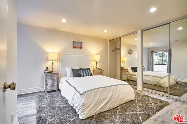
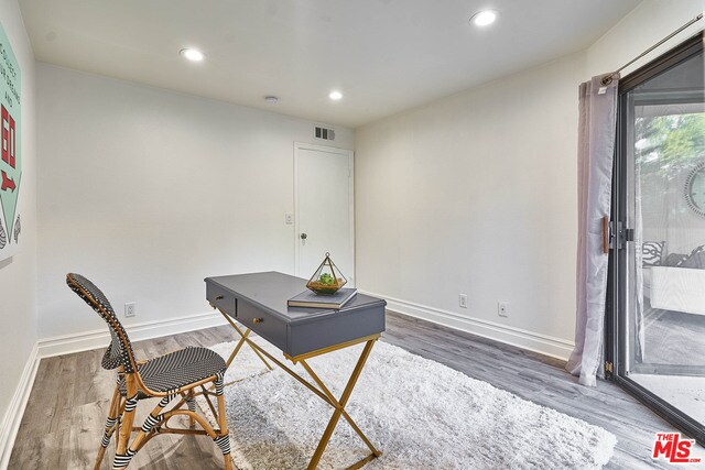
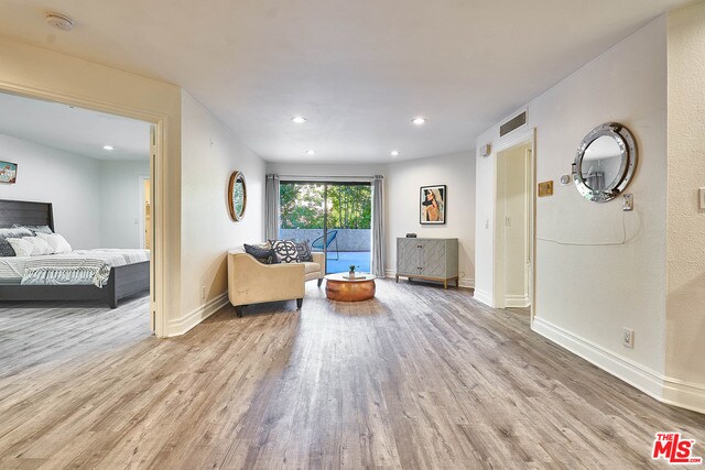
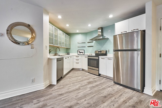
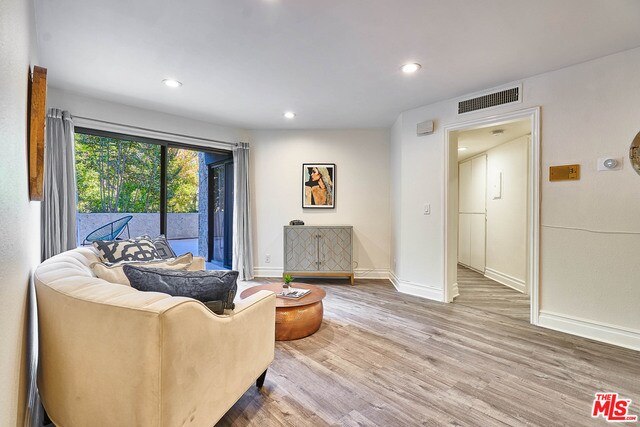
Huge patio!! Sunny views from every room!! Tasteful upgrades abound throughout this flowing 3 br/2 ba with a huge private patio, including floors and delightfully upgraded kitchen and baths. The gracious floor plan includes a formal dining area and a large living room that opens onto an expansive patio. The chef's kitchen has been thoughtfully updated with quartz counters with a glass tile backsplash, updated cabinetry, and upgraded appliances. Perfect for entertaining!! The large den/third bedroom offers a huge walk-in closet and direct access to the patio. The second bedroom offers direct patio access as well. The bathrooms feature upgraded enclosures and updated plumbing fixtures. The complex features resort-style amenities, including pool, spa, sundeck, and recreation room. Minutes from Old Pasadena, Paseo Colorado, the USC Health Sciences campus and the Gold Line!! It doesn't get better than this in Monterey Hills!!
4499 Via Marisol Via is a condo located in Los Angeles County and the 90042 ZIP Code. This area is served by the Los Angeles Unified attendance zone.
Condo Features
Washer/Dryer
Air Conditioning
Dishwasher
Refrigerator
- Washer/Dryer
- Air Conditioning
- Dishwasher
- Disposal
- Refrigerator
- Views
- Elevator
- Pool

Eaton Crest
144 Units
3 Stories
Built in 1981
320,012 Sq Ft
Eaton Crest is a three-story condominium building completed in 1981, located in the serene neighborhood of Montecito Heights. With 144 units, this community offers a blend of tranquility and accessibility, making it a desirable place to call home. The building's design incorporates a mix of curved and angular elements, providing a unique architectural flair that complements the lush surroundings. Its strategic location offers residents a peaceful retreat while being just minutes away from the vibrant life of Los Angeles.
Learn more about Eaton Crest
Location
Get Directions
A quiet suburb outside of Los Angeles, Monterey Hills is known for its rolling hills, winding residential streets, and elevated city views. Check out Elephant Hill, a popular place to bike or hike that offers beautiful views of the neighborhood. Herman Park is nestled along Highway 110 in the north end of the neighborhood, offering tennis courts, playgrounds, and a dog park. And for more outdoor recreation, visit the biking paths and hiking trails at Ernest E. Debs Regional Park, bordering Monterey Hills.
Monterey Hills is a more secluded part of Northeast Los Angeles with larger lots, single-family homes, and tree-lined streets. However, if you cross over Highway 110, you’ll find theatres, restaurants, services, and more. Monterey Hills is located just seven miles northeast of Downtown Los Angeles and eight miles east of major attractions such as Griffith Park, the Los Angeles Zoo, the Greek Theatre, and Glendale Galleria.
Learn more about living in Monterey HillsBelow are rent ranges for similar nearby apartments
Amenities
- Washer/Dryer
- Air Conditioning
- Dishwasher
- Disposal
- Refrigerator
- Views
- Elevator
- Pool
Education
| Colleges & Universities | Distance | ||
|---|---|---|---|
| Colleges & Universities | Distance | ||
| Drive: | 9 min | 3.7 mi | |
| Drive: | 8 min | 3.9 mi | |
| Drive: | 7 min | 4.1 mi | |
| Drive: | 11 min | 4.2 mi |
4499 Via Marisol Via Unit 120B is within 9 minutes or 3.7 miles from Occidental College. It is also near Cal State Los Angeles and Art Center College of Design.
Schools


Charter Elementary School
Grades K-5
75 Students
Nearby
Public Elementary School
Grades K-5
181 Students
Attendance Zone
Public Middle & High School
Grades 6-12
1,389 Students
Attendance Zone
Public Middle School
Grades 6-8
904 Students
Attendance Zone
Private Elementary School
Grades PK-5
131 Students
Nearby
Private Elementary, Middle & High School
Grades K-12
93 Students
Nearby
Private Elementary & Middle School
Grades K-8
Nearby
School data provided by
 The GreatSchools Rating helps parents compare schools within a state based on a variety of school quality indicators and provides a helpful picture of how effectively each school serves all of its students. Ratings are on a scale of 1 (below average) to 10 (above average) and can include test scores, college readiness, academic progress, advanced courses, equity, discipline and attendance data. We also advise parents to visit schools, consider other information on school performance and programs, and consider family needs as part of the school selection process.
View GreatSchools Rating Methodology
Data provided by GreatSchools.org © 2025. All rights reserved.
View GreatSchools Rating Methodology
Data provided by GreatSchools.org © 2025. All rights reserved.
Transportation options available in Los Angeles include Highland Park Station, located 1.5 miles from 4499 Via Marisol Via Unit 120B. 4499 Via Marisol Via Unit 120B is near Bob Hope, located 17.9 miles or 26 minutes away, and Los Angeles International, located 21.0 miles or 33 minutes away.
| Transit / Subway | Distance | ||
|---|---|---|---|
| Transit / Subway | Distance | ||
|
|
Drive: | 4 min | 1.5 mi |
|
|
Drive: | 6 min | 2.7 mi |
|
|
Drive: | 6 min | 3.0 mi |
|
|
Drive: | 5 min | 3.1 mi |
|
|
Drive: | 7 min | 3.7 mi |
| Commuter Rail | Distance | ||
|---|---|---|---|
| Commuter Rail | Distance | ||
|
|
Drive: | 11 min | 5.9 mi |
|
|
Drive: | 13 min | 6.0 mi |
|
|
Drive: | 12 min | 7.2 mi |
| Drive: | 15 min | 10.0 mi | |
|
|
Drive: | 21 min | 10.2 mi |
| Airports | Distance | ||
|---|---|---|---|
| Airports | Distance | ||
|
Bob Hope
|
Drive: | 26 min | 17.9 mi |
|
Los Angeles International
|
Drive: | 33 min | 21.0 mi |
Time and distance from 4499 Via Marisol Via Unit 120B.
| Shopping Centers | Distance | ||
|---|---|---|---|
| Shopping Centers | Distance | ||
| Drive: | 3 min | 1.3 mi | |
| Drive: | 4 min | 1.8 mi | |
| Drive: | 4 min | 2.0 mi |
4499 Via Marisol Via Unit 120B has 3 shopping centers within 2.0 miles, which is about a 4-minute drive. The miles and minutes will be for the farthest away property.
| Parks and Recreation | Distance | ||
|---|---|---|---|
| Parks and Recreation | Distance | ||
|
Audubon Center at Debs Park
|
Drive: | 4 min | 2.0 mi |
|
Chavez Ravine Arboretum
|
Drive: | 10 min | 5.7 mi |
|
Elysian Park
|
Drive: | 13 min | 5.7 mi |
|
Elyria Canyon Park
|
Drive: | 11 min | 6.0 mi |
|
Marsh Park
|
Drive: | 12 min | 6.3 mi |
4499 Via Marisol Via Unit 120B has 5 parks within 6.3 miles, including Audubon Center at Debs Park, Elyria Canyon Park, and Elysian Park.
| Hospitals | Distance | ||
|---|---|---|---|
| Hospitals | Distance | ||
| Drive: | 7 min | 3.6 mi | |
| Drive: | 9 min | 3.7 mi | |
| Drive: | 7 min | 4.5 mi |
4499 Via Marisol Via Unit 120B has 3 hospitals within 4.5 miles, the nearest is Keck Hospital of USC which is 3.6 miles away and a 7 minute drive.
| Military Bases | Distance | ||
|---|---|---|---|
| Military Bases | Distance | ||
| Drive: | 31 min | 22.6 mi | |
| Drive: | 42 min | 27.1 mi |
4499 Via Marisol Via Unit 120B is 22.6 miles from Los Angeles Air Force Base, and is convenient to other military bases, including Los Alamitos Army Airfield.
You May Also Like
Similar Rentals Nearby


What Are Walk Score®, Transit Score®, and Bike Score® Ratings?
Walk Score® measures the walkability of any address. Transit Score® measures access to public transit. Bike Score® measures the bikeability of any address.
What is a Sound Score Rating?
A Sound Score Rating aggregates noise caused by vehicle traffic, airplane traffic and local sources

4499 Via Marisol Via
Los Angeles, CA 90042