

$3,995 / Month
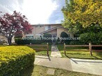
4474 Ariel Ave
Fremont, CA 94555
2 Weeks Ago
Favorites
4474 Ariel Ave

Favorites
Check Back Soon for Upcoming Availability
| Beds | Baths | Average SF |
|---|---|---|
| 4 Bedrooms 4 Bedrooms 4 Br | 2.5 Baths 2.5 Baths 2.5 Ba | 1,841 SF |
About This Property
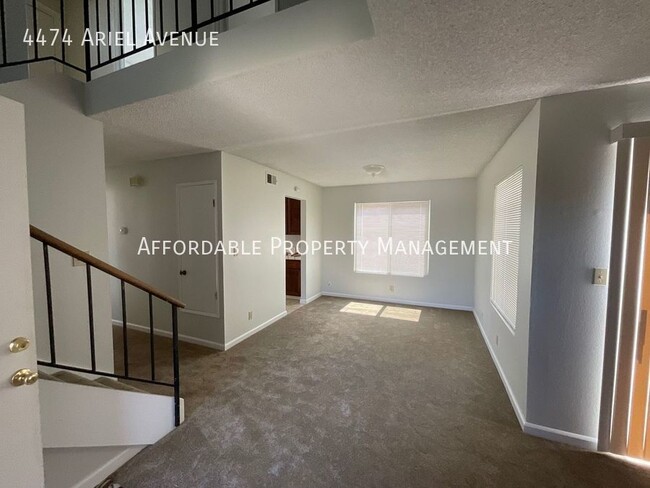
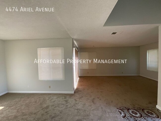
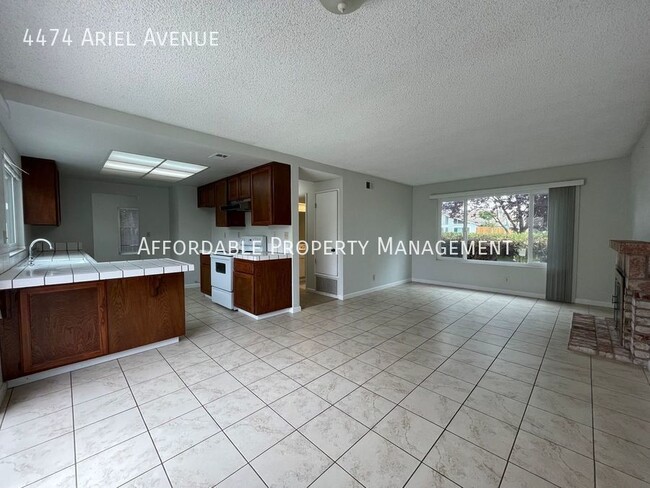
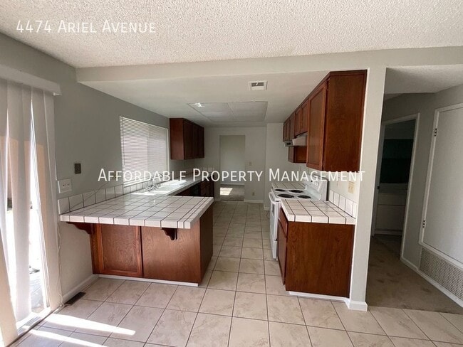
---- SCHEDULE A SHOWING ONLINE AT: ---- For additional details about this property, to view a video tour, schedule a self-guided tour, submit an application, or see our full list of available properties, please visit our website at . You can also contact us at . This property will be available on August 1, 2024! Introducing this gorgeous two-story home located in Fremont. Featuring four bedrooms, two and one half bathrooms, a family room, living room, dining area, and a two-car garage with garage door opener. The kitchen is equipped with a stove and dishwasher. There is carpet and tile flooring throughout the house. Additional features of this home include laundry hookups and a backyard. Located just minutes away from major highways, shopping, dining, and entertainment options. All utilities are to be paid by the tenant(s). No Pets Firm. Twelve month lease term. Renters insurance is required upon move-in. The property is being updated. It is not in a ready to move-in condition. CalBRE #01275192 2.5 Bathrooms 4 Bedrooms Carpet Dining Area House Laundry Hook Ups No Pets Firm No Utilities Included Renters Insurance Is Required Stove Tile Flooring Two Car Garage W/ Garage Door Opener Two Stories Window Coverings
4474 Ariel Ave is a house located in Alameda County and the 94555 ZIP Code. This area is served by the Fremont Unified attendance zone.
Location
Get Directions
Ardenwood is a family-friendly, suburban neighborhood about five miles northwest of Downtown Fremont. Similar to many Silicon Valley neighborhoods, Ardenwood is upscale with large, single-family homes and modern apartments and townhomes available for rent. Although renters from all walks of life can enjoy Ardenwood, families are attracted to the neighborhood for its excellent schools and abundance of childcare centers, while professionals enjoy easier commutes to some of Silicon Valley’s major tech companies.
Multiple neighborhood parks combined with proximity to the San Francisco Bay makes Ardenwood an ideal home for those who love to explore the outdoors. The 978-acre Coyote Hills Regional Park is located directly west of the Ardenwood, and the Quarry Lakes Regional Recreation Area and Central Park are both less than 20 minutes away.
Learn more about living in ArdenwoodBelow are rent ranges for similar nearby apartments
Education
| Colleges & Universities | Distance | ||
|---|---|---|---|
| Colleges & Universities | Distance | ||
| Drive: | 9 min | 6.1 mi | |
| Drive: | 13 min | 7.9 mi | |
| Drive: | 14 min | 8.7 mi | |
| Drive: | 18 min | 11.5 mi |
4474 Ariel Ave is within 9 minutes or 6.1 miles from Ohlone College, Newark. It is also near Chabot College and Cal State East Bay.
Schools


Charter Elementary School
Grades K-5
483 Students
Nearby
Public Elementary School
Grades 1-5
778 Students
Attendance Zone
Public Middle School
Grades 6-8
1,302 Students
Attendance Zone
Public High School
Grades 9-12
2,501 Students
Attendance Zone
Private Elementary & Middle School
Grades PK-8
806 Students
Nearby
Private Elementary, Middle & High School
Grades K-12
71 Students
Nearby
Private Elementary & Middle School
Grades PK-8
178 Students
Nearby
School data provided by
 The GreatSchools Rating helps parents compare schools within a state based on a variety of school quality indicators and provides a helpful picture of how effectively each school serves all of its students. Ratings are on a scale of 1 (below average) to 10 (above average) and can include test scores, college readiness, academic progress, advanced courses, equity, discipline and attendance data. We also advise parents to visit schools, consider other information on school performance and programs, and consider family needs as part of the school selection process.
View GreatSchools Rating Methodology
Data provided by GreatSchools.org © 2025. All rights reserved.
View GreatSchools Rating Methodology
Data provided by GreatSchools.org © 2025. All rights reserved.
Transportation options available in Fremont include Union City Station, located 3.8 miles from 4474 Ariel Ave. 4474 Ariel Ave is near Metro Oakland International, located 16.6 miles or 23 minutes away, and Norman Y Mineta San Jose International, located 20.9 miles or 27 minutes away.
| Transit / Subway | Distance | ||
|---|---|---|---|
| Transit / Subway | Distance | ||
|
|
Drive: | 8 min | 3.8 mi |
|
|
Drive: | 12 min | 5.9 mi |
|
|
Drive: | 12 min | 6.0 mi |
|
|
Drive: | 11 min | 6.6 mi |
|
|
Drive: | 13 min | 8.1 mi |
| Commuter Rail | Distance | ||
|---|---|---|---|
| Commuter Rail | Distance | ||
| Drive: | 7 min | 3.3 mi | |
| Drive: | 13 min | 8.5 mi | |
|
|
Drive: | 13 min | 8.5 mi |
| Drive: | 23 min | 12.3 mi | |
| Drive: | 23 min | 12.6 mi |
| Airports | Distance | ||
|---|---|---|---|
| Airports | Distance | ||
|
Metro Oakland International
|
Drive: | 23 min | 16.6 mi |
|
Norman Y Mineta San Jose International
|
Drive: | 27 min | 20.9 mi |
Time and distance from 4474 Ariel Ave.
| Shopping Centers | Distance | ||
|---|---|---|---|
| Shopping Centers | Distance | ||
| Walk: | 13 min | 0.7 mi | |
| Walk: | 19 min | 1.0 mi | |
| Drive: | 3 min | 1.1 mi |
4474 Ariel Ave has 3 shopping centers within 1.1 miles, which is about a 3-minute walk. The miles and minutes will be for the farthest away property.
| Parks and Recreation | Distance | ||
|---|---|---|---|
| Parks and Recreation | Distance | ||
|
Ardenwood Historic Farm
|
Drive: | 3 min | 1.2 mi |
|
Quarry Lakes Regional Recreation Area
|
Drive: | 6 min | 3.2 mi |
|
Coyote Hills Regional Park
|
Drive: | 7 min | 3.3 mi |
|
Alameda Creek Regional Trail
|
Drive: | 7 min | 3.4 mi |
|
San Francisco Bay National Wildlife Refuge
|
Drive: | 10 min | 4.4 mi |
4474 Ariel Ave has 5 parks within 4.4 miles, including Ardenwood Historic Farm, Quarry Lakes Regional Recreation Area, and Alameda Creek Regional Trail.
| Hospitals | Distance | ||
|---|---|---|---|
| Hospitals | Distance | ||
| Drive: | 9 min | 5.7 mi | |
| Drive: | 11 min | 5.8 mi | |
| Drive: | 11 min | 5.9 mi |
4474 Ariel Ave has 3 hospitals within 5.9 miles, the nearest is St. Rose Hospital which is 5.7 miles away and a 9 minute drive.
| Military Bases | Distance | ||
|---|---|---|---|
| Military Bases | Distance | ||
| Drive: | 30 min | 18.3 mi |
4474 Ariel Ave is 18.3 miles and a 30 minute drive from Ames Research Center.
You May Also Like
Similar Rentals Nearby


What Are Walk Score®, Transit Score®, and Bike Score® Ratings?
Walk Score® measures the walkability of any address. Transit Score® measures access to public transit. Bike Score® measures the bikeability of any address.
What is a Sound Score Rating?
A Sound Score Rating aggregates noise caused by vehicle traffic, airplane traffic and local sources
4474 Ariel Ave
Fremont, CA 94555