

$3,800
/ Month
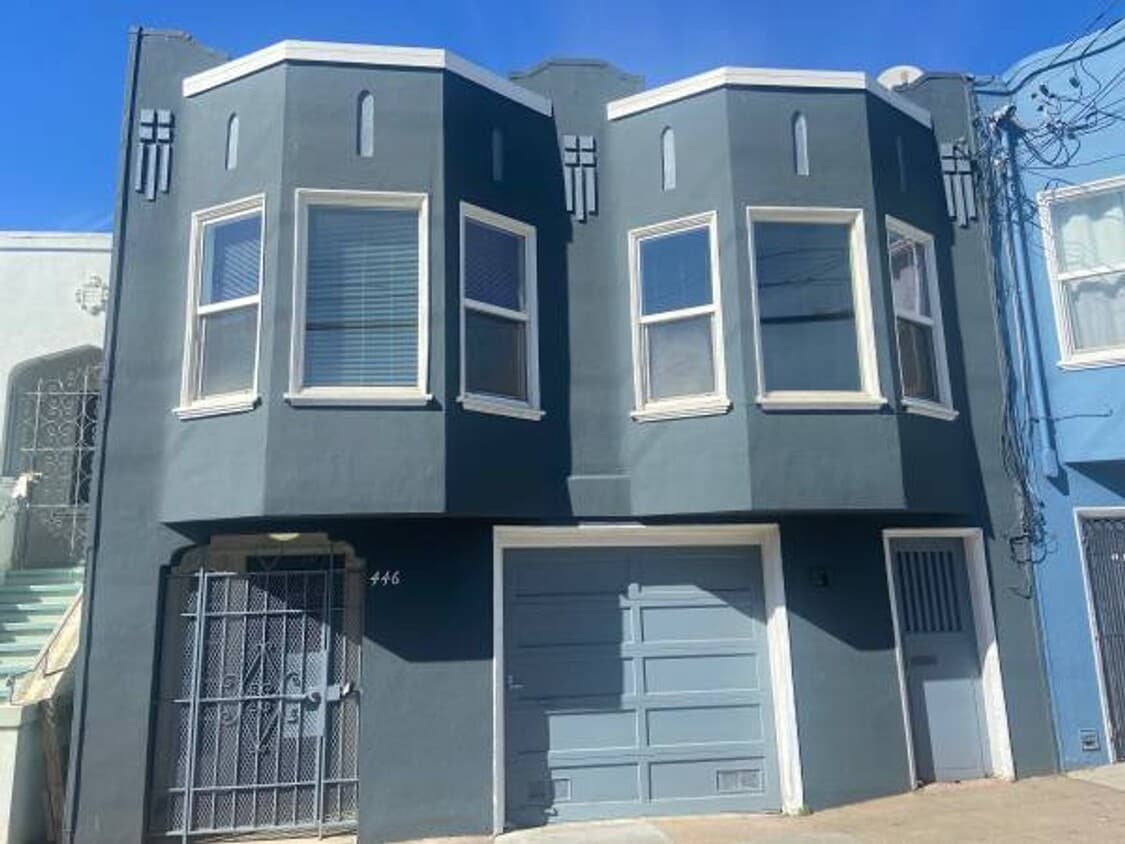
446 Athens St
San Francisco, CA 94112
Today
Favorites
415-747-4160
-
Bedrooms
2
-
Bathrooms
1
-
Square Feet
1,150 sq ft
-
Available
Available Now
446 Athens St

Favorites
About This Home
$3,800 deposit,
Available Now
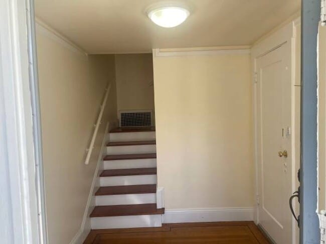
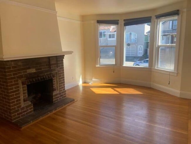
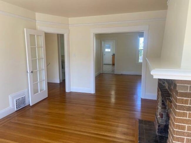
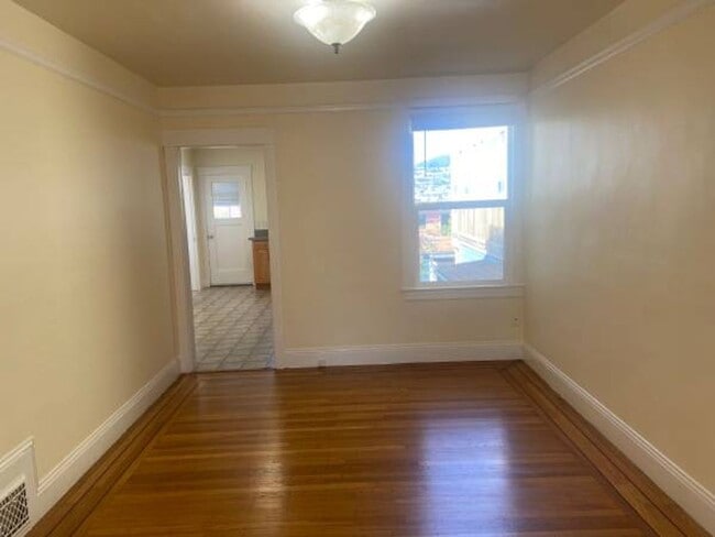
BRIGHT SUNNY ROOMS HARDWOOD FLOORS THROUGHOUT LARGE EAT-IN KITCHEN NEWER APPLIANCES WASHER / DRYER HOOK-UPS LIVING ROOM WITH DECO FIREPLACE DINING ROOM 2 CAR GARAGE AND STORAGE PATIO / YARD CONVENIENTLY LOCATED NEAR SHOPPING, SCHOOLS, RESTAURANTS, PUBLIC TRANSPORTATION, AND HIGHWAYS. Rent: $3,800 Security Deposit: $3,800 Non-smoking unit. Tenant pays all utilities. No Pets. One-year lease. MINIMUM FICO SCORE 650
446 Athens St is a house located in San Francisco County and the 94112 ZIP Code. This area is served by the San Francisco Unified attendance zone.
* Price shown is base rent. Excludes user-selected optional fees and variable or usage-based fees and required charges due at or prior to move-in or at move-out. Price, availability, fees, and any applicable rent special are subject to change without notice.
* Square footage definitions vary. Displayed square footage is approximate.
Contact
- Listed by Baldini Property Management | Baldini Property Management
- Phone Number
- Contact
Location
Get Directions
Perched on a hill overlooking Downtown San Francisco, Excelsior is regarded as an unpretentious enclave with a laidback atmosphere. Excelsior residents enjoy close proximity to the city as well as a reprieve from the hustle and bustle associated with city living.
A bevy of down-to-earth diners, corner stores, and multicultural markets are adorned with vibrant murals in Excelsior. Residents come together for a wide variety of exciting events in Excelsior, such as Jerry Day, the Excelsior Festival, the Excelsior District Annual Car Show, street fairs, and more.
Numerous popular parks near Excelsior provide plenty of opportunities for the community to come together as well, including John McLaren Park, Bernal Heights Park, Glen Canyon Park, and the renowned Twin Peaks.
Learn more about living in Excelsior
Education
| Colleges & Universities | Distance | ||
|---|---|---|---|
| Colleges & Universities | Distance | ||
| Drive: | 5 min | 1.6 mi | |
| Drive: | 11 min | 3.1 mi | |
| Drive: | 10 min | 5.0 mi | |
| Drive: | 13 min | 5.0 mi |
446 Athens St is within 5 minutes or 1.6 miles from City College of San Francisco. It is also near San Francisco State University and UC San Francisco, Parnassus.
Schools


Public Elementary School
Grades K-5
297 Students
Attendance Zone
Public Elementary School
Grades K-5
Nearby
Public Middle School
Grades 6-8
326 Students
Attendance Zone
Public High School
Grades 9-12
1,278 Students
Attendance Zone
Private Elementary & Middle School
Grades K-8
269 Students
Nearby
Private Elementary, Middle & High School
Grades K-12
Nearby
Private Elementary & Middle School
Grades PK-8
131 Students
Nearby
School data provided by
 The GreatSchools Rating helps parents compare schools within a state based on a variety of school quality indicators and provides a helpful picture of how effectively each school serves all of its students. Ratings are on a scale of 1 (below average) to 10 (above average) and can include test scores, college readiness, academic progress, advanced courses, equity, discipline and attendance data. We also advise parents to visit schools, consider other information on school performance and programs, and consider family needs as part of the school selection process.
View GreatSchools Rating Methodology
Data provided by GreatSchools.org © 2025. All rights reserved.
View GreatSchools Rating Methodology
Data provided by GreatSchools.org © 2025. All rights reserved.
Transportation options available in San Francisco include San Jose Ave & Santa Ynez Ave, located 0.9 mile from 446 Athens St. 446 Athens St is near San Francisco International, located 11.0 miles or 19 minutes away, and Metro Oakland International, located 24.1 miles or 37 minutes away.
| Transit / Subway | Distance | ||
|---|---|---|---|
| Transit / Subway | Distance | ||
|
|
Walk: | 17 min | 0.9 mi |
| Walk: | 19 min | 1.0 mi | |
|
|
Walk: | 19 min | 1.0 mi |
|
|
Drive: | 3 min | 1.1 mi |
|
|
Drive: | 3 min | 1.3 mi |
| Commuter Rail | Distance | ||
|---|---|---|---|
| Commuter Rail | Distance | ||
| Drive: | 6 min | 2.8 mi | |
| Drive: | 9 min | 4.8 mi | |
| Drive: | 9 min | 4.9 mi | |
| Drive: | 10 min | 5.7 mi | |
| Drive: | 10 min | 5.7 mi |
| Airports | Distance | ||
|---|---|---|---|
| Airports | Distance | ||
|
San Francisco International
|
Drive: | 19 min | 11.0 mi |
|
Metro Oakland International
|
Drive: | 37 min | 24.1 mi |
Time and distance from 446 Athens St.
| Shopping Centers | Distance | ||
|---|---|---|---|
| Shopping Centers | Distance | ||
| Drive: | 7 min | 2.0 mi | |
| Drive: | 7 min | 2.9 mi | |
| Drive: | 8 min | 3.0 mi |
446 Athens St has 3 shopping centers within 3.0 miles, which is about a 8-minute drive. The miles and minutes will be for the farthest away property.
| Parks and Recreation | Distance | ||
|---|---|---|---|
| Parks and Recreation | Distance | ||
|
Candlestick Point State Recreation Area
|
Drive: | 10 min | 3.5 mi |
|
San Bruno Mountain State Park
|
Drive: | 15 min | 4.8 mi |
|
San Francisco State Univ. Observatory
|
Drive: | 12 min | 4.9 mi |
|
Charles F. Hagar Planetarium
|
Drive: | 12 min | 4.9 mi |
|
Randall Museum
|
Drive: | 14 min | 5.1 mi |
446 Athens St has 5 parks within 5.1 miles, including San Francisco State Univ. Observatory, Charles F. Hagar Planetarium, and Candlestick Point State Recreation Area.
| Hospitals | Distance | ||
|---|---|---|---|
| Hospitals | Distance | ||
| Walk: | 16 min | 0.9 mi | |
| Drive: | 6 min | 2.7 mi | |
| Drive: | 9 min | 3.7 mi |
446 Athens St has 3 hospitals within 3.7 miles, the nearest is Jewish Home & Rehab Center which is 0.9 mile away and a 16 minute walk.
| Military Bases | Distance | ||
|---|---|---|---|
| Military Bases | Distance | ||
| Drive: | 22 min | 8.1 mi | |
| Drive: | 22 min | 8.7 mi |
446 Athens St is 8.1 miles from East Fort Miley, and is convenient to other military bases, including West Fort Miley.
You May Also Like
Similar Rentals Nearby
-
-

-

-

-

-
1 / 25

-

-

-
-


What Are Walk Score®, Transit Score®, and Bike Score® Ratings?
Walk Score® measures the walkability of any address. Transit Score® measures access to public transit. Bike Score® measures the bikeability of any address.
What is a Sound Score Rating?
A Sound Score Rating aggregates noise caused by vehicle traffic, airplane traffic and local sources
446 Athens St
San Francisco, CA 94112