

$5,400 / Month
440 Washington St
Wellesley, MA 02481
Today
Favorites
617-642-6458
-
Bedrooms
4
-
Bathrooms
2
-
Square Feet
1,750 sq ft
-
Available
Available Now
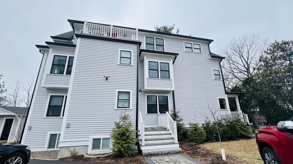
440 Washington St

Favorites
About This Home
$5,400 deposit,
Available Now
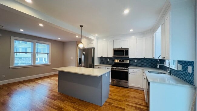
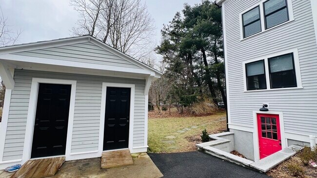
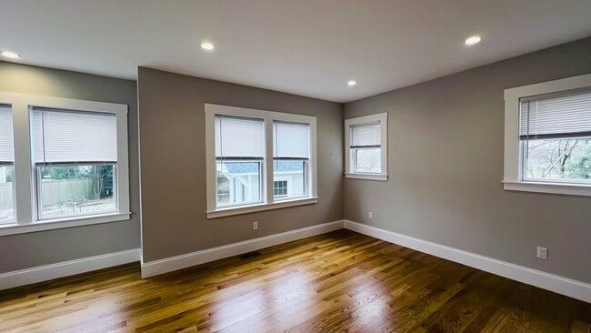
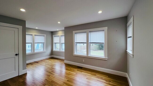
Gutted renovated first floor unit in two family home. Available 6/1. Commuter dream,within walking distance to Town center,Commercial spaces,Whole Foods,Wellesley High School & Middle School and commuter rail in Wellesley Hills. Ample parking spaces. Hardwood floors throughout and all modern amenities. Largedeck off kitchen family space opens up private yard are abutting Hunnewell Fields,central air and cooling,granite countertops and more. First month,Securitydeposit and Broker fee required. Tenant pays utilities separately. MLS# 73345848
440 Washington St is a townhome located in Norfolk County and the 02481 ZIP Code. This area is served by the Wellesley attendance zone.
* Price shown is base rent and may not include non-optional fees and utilities.
Price, availability, fees, and any applicable rent special are subject to change without notice.
* Square footage definitions vary. Displayed square footage is approximate.
Contact
- Listed by Shasha Chang | Peace of Mind Realty
- Phone Number
-
Source
 MLS Property Information Network
The property listing data and information set forth herein were provided to MLS Property Information Network, Inc. from third party sources, including sellers, lessors and public records, and were compiled by MLS Property Information Network, Inc. The property listing data and information are for the personal, non-commercial use of consumers having a good faith interest in purchasing or leasing listed properties of the type displayed to them and may not be used for any purpose other than to identify prospective properties which such consumers may have a good faith interest in purchasing or leasing. MLS Property Information Network, Inc. and its subscribers disclaim any and all representations and warranties as to the accuracy of the property listing data and information set forth herein. All properties are subject to prior sale, change or withdrawal. Copyright © 2025 MLS Property Information Network, Inc. All rights reserved.
Location
Get Directions
Just west of Boston and East of Worcester sits Metro West, a region that houses a group of towns and cities with significant historical backgrounds. A total of 19 municipalities make up the core of this community, but other municipalities are considered to be a part of the Interstate 495/Metro West Corridor.
Learn more about living in Metro West
Education
| Colleges & Universities | Distance | ||
|---|---|---|---|
| Colleges & Universities | Distance | ||
| Drive: | 5 min | 1.9 mi | |
| Drive: | 5 min | 2.0 mi | |
| Drive: | 12 min | 5.4 mi | |
| Drive: | 14 min | 7.6 mi |
440 Washington St is within 5 minutes or 1.9 miles from Babson College. It is also near Wellesley College and Brandeis University.
Schools


Public Elementary School
Grades K-5
198 Students
Attendance Zone
Public Elementary School
Grades K-5
280 Students
Nearby
Public Middle School
Grades 6-8
922 Students
Attendance Zone
Public High School
Grades 9-12
1,412 Students
Attendance Zone
Private Elementary & Middle School
Grades PK-8
185 Students
Nearby
Private Middle & High School
Grades 6-12
475 Students
Nearby
School data provided by
 The GreatSchools Rating helps parents compare schools within a state based on a variety of school quality indicators and provides a helpful picture of how effectively each school serves all of its students. Ratings are on a scale of 1 (below average) to 10 (above average) and can include test scores, college readiness, academic progress, advanced courses, equity, discipline and attendance data. We also advise parents to visit schools, consider other information on school performance and programs, and consider family needs as part of the school selection process.
View GreatSchools Rating Methodology
Data provided by GreatSchools.org © 2025. All rights reserved.
View GreatSchools Rating Methodology
Data provided by GreatSchools.org © 2025. All rights reserved.
Transportation options available in Wellesley include Woodland Station, located 2.9 miles from 440 Washington St. 440 Washington St is near General Edward Lawrence Logan International, located 16.9 miles or 27 minutes away, and Worcester Regional, located 32.8 miles or 55 minutes away.
| Transit / Subway | Distance | ||
|---|---|---|---|
| Transit / Subway | Distance | ||
|
|
Drive: | 5 min | 2.9 mi |
|
|
Drive: | 7 min | 3.0 mi |
|
|
Drive: | 7 min | 3.6 mi |
|
|
Drive: | 8 min | 4.2 mi |
|
|
Drive: | 8 min | 4.4 mi |
| Commuter Rail | Distance | ||
|---|---|---|---|
| Commuter Rail | Distance | ||
|
|
Walk: | 10 min | 0.5 mi |
|
|
Walk: | 22 min | 1.2 mi |
|
|
Drive: | 4 min | 1.7 mi |
|
|
Drive: | 7 min | 3.0 mi |
|
|
Drive: | 7 min | 3.6 mi |
| Airports | Distance | ||
|---|---|---|---|
| Airports | Distance | ||
|
General Edward Lawrence Logan International
|
Drive: | 27 min | 16.9 mi |
|
Worcester Regional
|
Drive: | 55 min | 32.8 mi |
Time and distance from 440 Washington St.
| Shopping Centers | Distance | ||
|---|---|---|---|
| Shopping Centers | Distance | ||
| Walk: | 6 min | 0.4 mi | |
| Walk: | 15 min | 0.8 mi | |
| Walk: | 20 min | 1.0 mi |
440 Washington St has 3 shopping centers within 1.0 miles, which is about a 20-minute walk. The miles and minutes will be for the farthest away property.
| Parks and Recreation | Distance | ||
|---|---|---|---|
| Parks and Recreation | Distance | ||
|
Whitin Observatory
|
Drive: | 4 min | 1.5 mi |
|
Wellesley College Botanic Gardens
|
Drive: | 3 min | 1.7 mi |
|
Weezie's Garden for Children
|
Drive: | 8 min | 3.2 mi |
|
Elm Bank Reservation
|
Drive: | 8 min | 3.2 mi |
|
Horticultural Society at Elm Bank
|
Drive: | 10 min | 3.4 mi |
440 Washington St has 5 parks within 3.4 miles, including Whitin Observatory, Wellesley College Botanic Gardens, and Horticultural Society at Elm Bank.
| Hospitals | Distance | ||
|---|---|---|---|
| Hospitals | Distance | ||
| Drive: | 4 min | 2.6 mi | |
| Drive: | 7 min | 3.8 mi | |
| Drive: | 12 min | 5.9 mi |
440 Washington St has 3 hospitals within 5.9 miles, the nearest is Newton - Wellesley Hospital which is 2.6 miles away and a 4 minute drive.
| Military Bases | Distance | ||
|---|---|---|---|
| Military Bases | Distance | ||
| Drive: | 9 min | 4.6 mi | |
| Drive: | 23 min | 12.8 mi |
440 Washington St is 4.6 miles from US Military Reservation, and is convenient to other military bases, including Hanscom Air Force Base.
You May Also Like
Similar Rentals Nearby


What Are Walk Score®, Transit Score®, and Bike Score® Ratings?
Walk Score® measures the walkability of any address. Transit Score® measures access to public transit. Bike Score® measures the bikeability of any address.
What is a Sound Score Rating?
A Sound Score Rating aggregates noise caused by vehicle traffic, airplane traffic and local sources
440 Washington St
Wellesley, MA 02481