
$2,800
/ Month
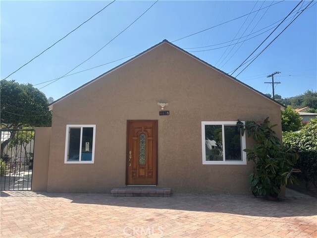
440 Redfield Ave
Los Angeles, CA 90042
Today
Favorites
626-360-8476
-
Bedrooms
2
-
Bathrooms
1
-
Square Feet
820 sq ft
-
Available
Available Now
Highlights
- Cooling Available
- 1-Story Property
440 Redfield Ave

Favorites
About This Home
12 Month Lease,
$2,800 deposit,
Available Now
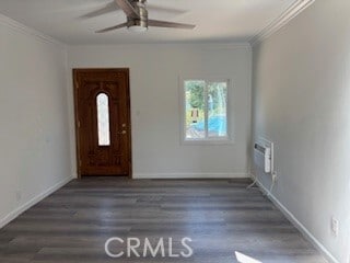
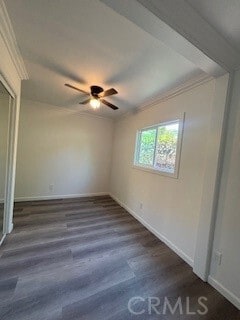
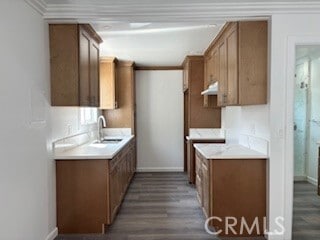
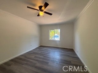
Discover this beautifully renovated 2-bedroom, 1-bath home in the charming city of Los Angeles. Ideally situated near a wide variety of restaurants and just minutes from Pasadena and Downtown, this residence offers both comfort and convenience. Thoughtfully updated and move-in ready, this home is the perfect opportunity to enjoy city living at its best. Don’t miss your chance to make it yours. MLS# PF25217680
440 Redfield Ave is a townhome located in Los Angeles County and the 90042 ZIP Code. This area is served by the Los Angeles Unified attendance zone.
* Price shown is base rent. Excludes user-selected optional fees and variable or usage-based fees and required charges due at or prior to move-in or at move-out. Price, availability, fees, and any applicable rent special are subject to change without notice.
* Square footage definitions vary. Displayed square footage is approximate.
Home Details
Home Type
Duplex
Year Built
Built in 1927
Bedrooms and Bathrooms
2 Main Level Bedrooms
1 Full Bathroom
Home Design
Entry on the 1st floor
Interior Spaces
820 Sq Ft Home
1-Story Property
Listing and Financial Details
Security Deposit $2,800
12-Month Minimum Lease Term
Available 9/15/25
Assessor Parcel Number 5301007017
Rent includes water
Location
Suburban Location
Lot Details
6,257 Sq Ft Lot
No Common Walls
Density is up to 1 Unit/Acre
Outdoor Features
Exterior Lighting
Utilities
Cooling Available
Community Details
Overview
2 Units
No Home Owners Association
Fees and Policies
The fees below are based on community-supplied data and may exclude additional fees and utilities.
Details
Utilities Included
-
Water
Lease Options
-
12 Months
Contact
- Listed by Dina Corchado | BOT Real Estate
- Phone Number
- Contact
-
Source
 California Regional Multiple Listing Service
Copyright 2025 © California Regional MLS. All rights reserved.
Location
Get Directions
Amenities
- Air Conditioning
Expenses
Utilities Included
Water
Included
A quiet suburb outside of Los Angeles, Monterey Hills is known for its rolling hills, winding residential streets, and elevated city views. Check out Elephant Hill, a popular place to bike or hike that offers beautiful views of the neighborhood. Herman Park is nestled along Highway 110 in the north end of the neighborhood, offering tennis courts, playgrounds, and a dog park. And for more outdoor recreation, visit the biking paths and hiking trails at Ernest E. Debs Regional Park, bordering Monterey Hills.
Monterey Hills is a more secluded part of Northeast Los Angeles with larger lots, single-family homes, and tree-lined streets. However, if you cross over Highway 110, you’ll find theatres, restaurants, services, and more. Monterey Hills is located just seven miles northeast of Downtown Los Angeles and eight miles east of major attractions such as Griffith Park, the Los Angeles Zoo, the Greek Theatre, and Glendale Galleria.
Learn more about living in Monterey Hills
Education
| Colleges & Universities | Distance | ||
|---|---|---|---|
| Colleges & Universities | Distance | ||
| Drive: | 8 min | 3.3 mi | |
| Drive: | 6 min | 3.7 mi | |
| Drive: | 8 min | 3.8 mi | |
| Drive: | 11 min | 4.8 mi |
440 Redfield Ave is within 8 minutes or 3.3 miles from Occidental College. It is also near Art Center College of Design and USC, Health Sciences Campus.
Schools


Public Elementary School
Grades K-5
181 Students
Attendance Zone
Charter Elementary School
Grades K-5
75 Students
Nearby
Public Middle & High School
Grades 6-12
1,389 Students
Attendance Zone
Public Middle School
Grades 6-8
904 Students
Attendance Zone
Private Elementary School
Grades K-6
Nearby
Private Elementary & Middle School
Grades PK-8
202 Students
Nearby
Private Elementary, Middle & High School
Grades K-12
Nearby
Private Elementary School
Grades PK-5
131 Students
Nearby
School data provided by
 The GreatSchools Rating helps parents compare schools within a state based on a variety of school quality indicators and provides a helpful picture of how effectively each school serves all of its students. Ratings are on a scale of 1 (below average) to 10 (above average) and can include test scores, college readiness, academic progress, advanced courses, equity, discipline and attendance data. We also advise parents to visit schools, consider other information on school performance and programs, and consider family needs as part of the school selection process.
View GreatSchools Rating Methodology
Data provided by GreatSchools.org © 2025. All rights reserved.
View GreatSchools Rating Methodology
Data provided by GreatSchools.org © 2025. All rights reserved.
Transportation options available in Los Angeles include Highland Park Station, located 1.1 miles from 440 Redfield Ave. 440 Redfield Ave is near Bob Hope, located 17.5 miles or 25 minutes away, and Los Angeles International, located 20.6 miles or 33 minutes away.
| Transit / Subway | Distance | ||
|---|---|---|---|
| Transit / Subway | Distance | ||
|
|
Drive: | 3 min | 1.1 mi |
|
|
Drive: | 5 min | 2.3 mi |
|
|
Drive: | 5 min | 2.6 mi |
|
|
Drive: | 4 min | 2.7 mi |
|
|
Drive: | 6 min | 3.3 mi |
| Commuter Rail | Distance | ||
|---|---|---|---|
| Commuter Rail | Distance | ||
|
|
Drive: | 10 min | 5.5 mi |
|
|
Drive: | 12 min | 5.6 mi |
|
|
Drive: | 11 min | 6.8 mi |
| Drive: | 14 min | 9.6 mi | |
|
|
Drive: | 21 min | 10.8 mi |
| Airports | Distance | ||
|---|---|---|---|
| Airports | Distance | ||
|
Bob Hope
|
Drive: | 25 min | 17.5 mi |
|
Los Angeles International
|
Drive: | 33 min | 20.6 mi |
Time and distance from 440 Redfield Ave.
| Shopping Centers | Distance | ||
|---|---|---|---|
| Shopping Centers | Distance | ||
| Walk: | 17 min | 0.9 mi | |
| Drive: | 3 min | 1.4 mi | |
| Drive: | 3 min | 1.4 mi |
440 Redfield Ave has 3 shopping centers within 1.4 miles, which is about a 3-minute walk. The miles and minutes will be for the farthest away property.
| Parks and Recreation | Distance | ||
|---|---|---|---|
| Parks and Recreation | Distance | ||
|
Audubon Center at Debs Park
|
Drive: | 4 min | 1.5 mi |
|
Chavez Ravine Arboretum
|
Drive: | 9 min | 5.2 mi |
|
Elysian Park
|
Drive: | 12 min | 5.3 mi |
|
Elyria Canyon Park
|
Drive: | 10 min | 5.5 mi |
|
Marsh Park
|
Drive: | 11 min | 5.8 mi |
440 Redfield Ave has 5 parks within 5.8 miles, including Audubon Center at Debs Park, Elyria Canyon Park, and Elysian Park.
| Hospitals | Distance | ||
|---|---|---|---|
| Hospitals | Distance | ||
| Drive: | 7 min | 3.5 mi | |
| Drive: | 6 min | 4.1 mi | |
| Drive: | 9 min | 4.1 mi |
440 Redfield Ave has 3 hospitals within 4.1 miles, the nearest is Keck Hospital of USC which is 3.5 miles away and a 7 minute drive.
| Military Bases | Distance | ||
|---|---|---|---|
| Military Bases | Distance | ||
| Drive: | 30 min | 22.1 mi | |
| Drive: | 43 min | 28.6 mi |
440 Redfield Ave is 22.1 miles from Los Angeles Air Force Base, and is convenient to other military bases, including Los Alamitos Army Airfield.
You May Also Like
Similar Rentals Nearby


What Are Walk Score®, Transit Score®, and Bike Score® Ratings?
Walk Score® measures the walkability of any address. Transit Score® measures access to public transit. Bike Score® measures the bikeability of any address.
What is a Sound Score Rating?
A Sound Score Rating aggregates noise caused by vehicle traffic, airplane traffic and local sources
440 Redfield Ave
Los Angeles, CA 90042