
$4,300
Total Monthly Price
43858 Merryoak Way
Ashburn, VA 20147
2 Weeks Ago
|
Edit
Favorites
43858 Merryoak Way

Favorites
Check Back Soon for Upcoming Availability
| Beds | Baths | Average SF |
|---|---|---|
| 5 Bedrooms 5 Bedrooms 5 Br | 4 Baths 4 Baths 4 Ba | 3,613 SF |
About This Property
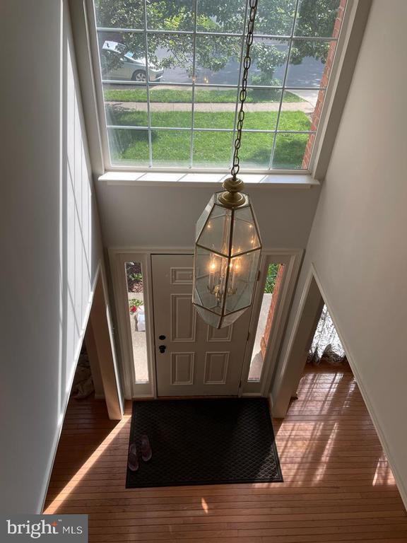
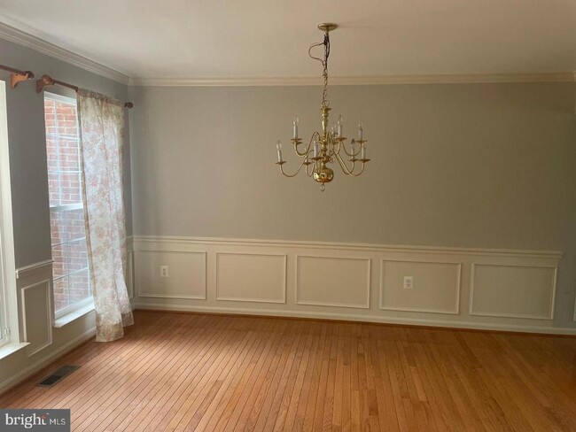
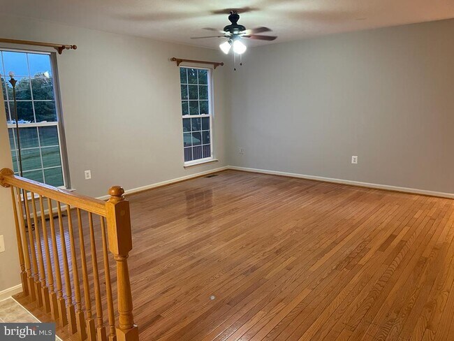
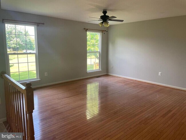
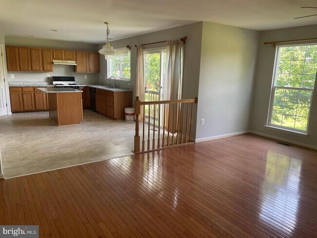
Colonial Brick Front detached Single Family House , main level with hardwood floors with 1 bedroom, 1 full bath, living room, dining room, family room and large well-lit kitchen washer dryer room from garage. 2nd level with Hardwood floors has 4 bedrooms plus 2 full baths.. Located near ONE LOUDOUN Whole Foods Traders Joes, dream commuting location and close to Major highways Route 7, Route 28, Dulles Access Road, Close to many shopping centers and Companies, Swimming Pool, Basketball and Tennis Court, Walking Trails, Near W&O Bike Path, Near Academy of Science, Stone Bridge High School, Ashburn Lake with Gazebo, Near Dulles Airport. Near Reston Town Center,
43858 Merryoak Way is a house located in Loudoun County and the 20147 ZIP Code. This area is served by the Loudoun County Public Schools attendance zone.
House Features
- Basement
43858 Merryoak Way,
Ashburn,
VA
20147
In the Belmont neighborhood, rental units on Gloucester Parkway place you near Newton-Lee elementary school and Trailside middle school. Travel 2.1 miles to reach Belmont Country Club and Golf Course, and approximately 1.9 miles to reach Interstate 7. Visit Beth Miller Park and relax under the gazebo, or take your dog for a walk across this nine-acre property.
Tee off at the 18-hole Brambleton Golf Course, featuring large sand traps and bunkered greens, and then sip on a cold brew at the Brambleton Ale House or plan a lavish outdoor event at its scenic outdoor pavilion. For casual dining, visit Cooper's Hawk Winery and Restaurant, which also features a tasting room and gift store.
Learn more about living in BelmontBelow are rent ranges for similar nearby apartments
Amenities
- Basement
Education
| Colleges & Universities | Distance | ||
|---|---|---|---|
| Colleges & Universities | Distance | ||
| Drive: | 8 min | 3.9 mi | |
| Drive: | 11 min | 6.2 mi | |
| Drive: | 12 min | 6.6 mi | |
| Drive: | 52 min | 33.8 mi |
43858 Merryoak Way is within 8 minutes or 3.9 miles from GWU, Virginia Sci. and Tech.. It is also near NOVA, Loudoun Campus and George Mason University.
Schools


Public Elementary School
Grades PK-5
730 Students
Attendance Zone
Public Middle School
Grades 6-8
1,148 Students
Attendance Zone
Public High School
Grades 9-12
1,701 Students
Attendance Zone
Private Elementary, Middle & High School
Grades PK-12
672 Students
Nearby
Private Middle & High School
Grades 6-12
Nearby
School data provided by
 The GreatSchools Rating helps parents compare schools within a state based on a variety of school quality indicators and provides a helpful picture of how effectively each school serves all of its students. Ratings are on a scale of 1 (below average) to 10 (above average) and can include test scores, college readiness, academic progress, advanced courses, equity, discipline and attendance data. We also advise parents to visit schools, consider other information on school performance and programs, and consider family needs as part of the school selection process.
View GreatSchools Rating Methodology
Data provided by GreatSchools.org © 2026. All rights reserved.
View GreatSchools Rating Methodology
Data provided by GreatSchools.org © 2026. All rights reserved.
Transportation options available in Ashburn include Ashburn, Silver Line Center Platform, located 5.9 miles from 43858 Merryoak Way. 43858 Merryoak Way is near Washington Dulles International, located 10.6 miles or 21 minutes away, and Ronald Reagan Washington Ntl, located 33.4 miles or 52 minutes away.
| Transit / Subway | Distance | ||
|---|---|---|---|
| Transit / Subway | Distance | ||
| Drive: | 11 min | 5.9 mi | |
| Drive: | 11 min | 7.4 mi | |
| Drive: | 17 min | 9.7 mi | |
| Drive: | 23 min | 13.3 mi | |
| Drive: | 23 min | 14.3 mi |
| Commuter Rail | Distance | ||
|---|---|---|---|
| Commuter Rail | Distance | ||
|
Dickerson Marc Eb
|
Drive: | 45 min | 27.2 mi |
|
Barnesville Marc Eb
|
Drive: | 54 min | 31.0 mi |
| Drive: | 63 min | 34.8 mi | |
| Drive: | 58 min | 37.6 mi | |
| Drive: | 63 min | 41.7 mi |
| Airports | Distance | ||
|---|---|---|---|
| Airports | Distance | ||
|
Washington Dulles International
|
Drive: | 21 min | 10.6 mi |
|
Ronald Reagan Washington Ntl
|
Drive: | 52 min | 33.4 mi |
Walkability Near 43858 Merryoak Way Ashburn, VA 20147
Getting Around
 What do Walkability, Transit, Drivability, and Bikeability mean?
Walkability measures the walking distance to day-to-day needs.
Transit measures access to public transportation.
Drivability measures congestion, parking availability, and access to major roads.
Bikeability measures the suitability for cycling.
How It Works
What do Walkability, Transit, Drivability, and Bikeability mean?
Walkability measures the walking distance to day-to-day needs.
Transit measures access to public transportation.
Drivability measures congestion, parking availability, and access to major roads.
Bikeability measures the suitability for cycling.
How It Works
Fairly Walkable
Walkability
50
/ 100
Limited Public Transit
Transit
30
/ 100
Moderately Drivable
Drivability
70
/ 100
Moderately Bikeable
Bikeability
70
/ 100
Scores provided by
-
Soundscore™
-
/ 100
Traffic
-Airport
-Businesses
-Scores provided by
HowLoud What is a Sound Score Rating? A Sound Score Rating aggregates noise caused by vehicle traffic, airplane traffic and local sources. How It WorksTime and distance from 43858 Merryoak Way.
| Shopping Centers | Distance | ||
|---|---|---|---|
| Shopping Centers | Distance | ||
| Walk: | 16 min | 0.8 mi | |
| Walk: | 20 min | 1.1 mi | |
| Drive: | 3 min | 1.1 mi |
43858 Merryoak Way has 3 shopping centers within 1.1 miles, which is about a 3-minute drive. The miles and minutes will be for the farthest away property.
| Parks and Recreation | Distance | ||
|---|---|---|---|
| Parks and Recreation | Distance | ||
|
Washington & Old Dominion Railroad Trail
|
Drive: | 6 min | 2.9 mi |
|
Claude Moore Park
|
Drive: | 12 min | 5.6 mi |
|
Red Rock Wilderness Regional Park
|
Drive: | 11 min | 6.1 mi |
|
Ball's Bluff Battlefield Regional Park
|
Drive: | 16 min | 8.4 mi |
|
Banshee Reeks Nature Preserve
|
Drive: | 15 min | 9.4 mi |
43858 Merryoak Way has 5 parks within 9.4 miles, including Washington & Old Dominion Railroad Trail, Claude Moore Park, and Red Rock Wilderness Regional Park.
| Hospitals | Distance | ||
|---|---|---|---|
| Hospitals | Distance | ||
| Drive: | 4 min | 2.3 mi | |
| Drive: | 20 min | 10.9 mi | |
| Drive: | 20 min | 11.9 mi |
43858 Merryoak Way has 3 hospitals within 11.9 miles, the nearest is Inova Loudoun Hospital which is 2.3 miles away and a 4 minute drive.
| Military Bases | Distance | ||
|---|---|---|---|
| Military Bases | Distance | ||
| Drive: | 52 min | 34.3 mi |
43858 Merryoak Way is 34.3 miles and a 52 minute drive from Vint Hill Farms Station.
You May Also Like
Similar Rentals Nearby
-
-

-

-

-

-

-

-

-
 7 Beds, 8 Baths, 8,469 sq ft$15,000Total Monthly PriceTotal Monthly Price NewPrices include all required monthly fees.9864 Walker Glen Ct
 -
 4 Beds, 3 Baths, 1,816 sq ft$4,500Total Monthly PriceTotal Monthly Price NewPrices include all required monthly fees.4005 Lees Corner Rd
What Are Walk Score®, Transit Score®, and Bike Score® Ratings?
Walk Score® measures the walkability of any address. Transit Score® measures access to public transit. Bike Score® measures the bikeability of any address.
What is a Sound Score Rating?
A Sound Score Rating aggregates noise caused by vehicle traffic, airplane traffic and local sources.

43858 Merryoak Way
Ashburn, VA 20147