
$4,450 / Month
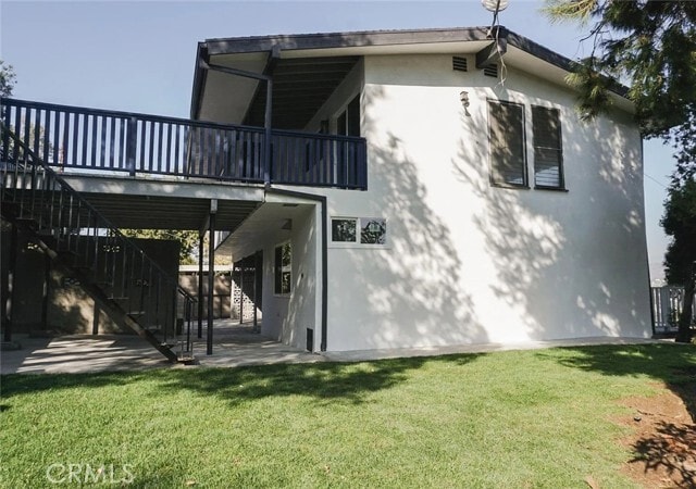
430 Terrill Ave
Los Angeles, CA 90042
Today
Favorites
323-620-5296
-
Bedrooms
2
-
Bathrooms
3
-
Square Feet
1,616 sq ft
-
Available
Available Now
Highlights
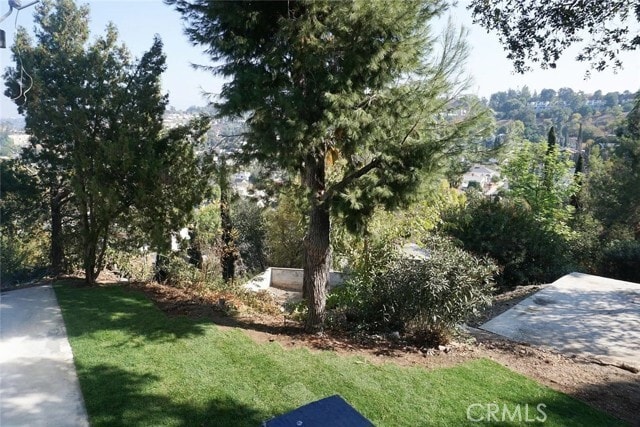
- Neighborhood Views
- Hiking Trails
- Park
- Laundry Room
- Central Air
- Dogs and Cats Allowed
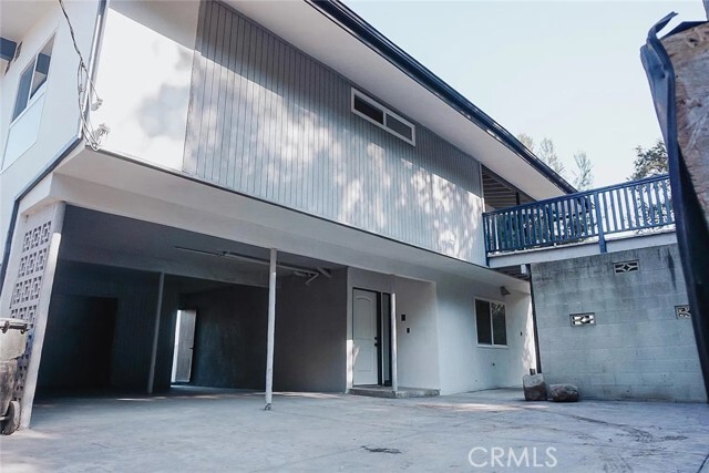
430 Terrill Ave

Favorites
About This Home
12 Month Lease,
$4,450 deposit,
Available Now
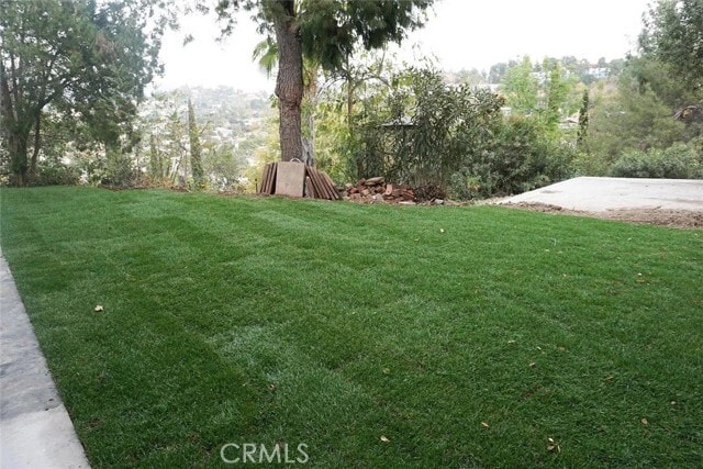
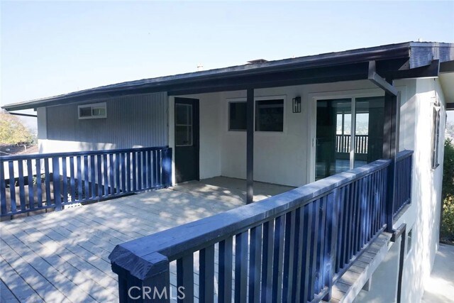
3 bedroom/ 2 bath unit with an amazing view of the city. Conveniently located just off the 110 freeway, and minutes away from South Pasadena, Highland Park, and Downtown LA.Your own private park-like setting oasis***Very private street** House is located at the end of a private small road minutes away from all the cool hip restaurants on Figueroa.Master bedroom has its own private bathroom. This unit is great for all your needs with incredible views from your very own living room. It also has a private deck in the back side of the house for any kind of entertainment. Not to mention your backyard has a gate that opens up to walking trails leading to the lake and Earnest Debs Park. Unit is on the second floor. MLS# DW25185133
430 Terrill Ave is a townhome located in Los Angeles County and the 90042 ZIP Code. This area is served by the Los Angeles Unified attendance zone.
* Price shown is base rent and may not include non-optional fees and utilities.
Price, availability, fees, and any applicable rent special are subject to change without notice.
* Square footage definitions vary. Displayed square footage is approximate.
Home Details
Home Type
Duplex
Year Built
Built in 1961
Accessible Home Design
Entry on the 1st floor
Bedrooms and Bathrooms
2 Bedrooms | 3 Main Level Bedrooms
3 Full Bathrooms
All Upper Level Bedrooms
Interior Spaces
1,616 Sq Ft Home
2-Story Property
Laundry
Laundry Room
Listing and Financial Details
Security Deposit $4,450
12-Month Minimum Lease Term
Available 8/18/25
Legal Lot and Block 5 / 21
Tax Tract Number 4
Assessor Parcel Number 5301005016
Lot Details
6,883 Sq Ft Lot
1 Common Wall
Property is zoned LAR1
Sprinkler System
Utilities
Central Air
Views
Neighborhood Views
Community Details
Overview
2 Units
No Home Owners Association
Pet Policy
Dogs and Cats Allowed
Pet Deposit $350
Recreation
Hiking Trails
Park
Fees and Policies
The fees below are based on community-supplied data and may exclude additional fees and utilities.
- Dogs Allowed
-
Fees not specified
- Cats Allowed
-
Fees not specified
Details
Lease Options
-
12 Months
Contact
- Listed by Rudy Felix | VIP RE Firm
- Phone Number
- Contact
-
Source
 California Regional Multiple Listing Service
Copyright 2025 © California Regional MLS. All rights reserved.
Location
Get Directions
Amenities
- Air Conditioning
A quiet suburb outside of Los Angeles, Monterey Hills is known for its rolling hills, winding residential streets, and elevated city views. Check out Elephant Hill, a popular place to bike or hike that offers beautiful views of the neighborhood. Herman Park is nestled along Highway 110 in the north end of the neighborhood, offering tennis courts, playgrounds, and a dog park. And for more outdoor recreation, visit the biking paths and hiking trails at Ernest E. Debs Regional Park, bordering Monterey Hills.
Monterey Hills is a more secluded part of Northeast Los Angeles with larger lots, single-family homes, and tree-lined streets. However, if you cross over Highway 110, you’ll find theatres, restaurants, services, and more. Monterey Hills is located just seven miles northeast of Downtown Los Angeles and eight miles east of major attractions such as Griffith Park, the Los Angeles Zoo, the Greek Theatre, and Glendale Galleria.
Learn more about living in Monterey Hills
Education
| Colleges & Universities | Distance | ||
|---|---|---|---|
| Colleges & Universities | Distance | ||
| Drive: | 9 min | 3.4 mi | |
| Drive: | 8 min | 3.7 mi | |
| Drive: | 7 min | 3.8 mi | |
| Drive: | 11 min | 4.7 mi |
430 Terrill Ave is within 9 minutes or 3.4 miles from Occidental College. It is also near Art Center College of Design and USC, Health Sciences Campus.
Schools


Public Elementary School
Grades K-5
181 Students
Attendance Zone
Charter Elementary School
Grades K-5
75 Students
Nearby
Public Middle & High School
Grades 6-12
1,389 Students
Attendance Zone
Public Middle School
Grades 6-8
904 Students
Attendance Zone
Private Elementary School
Grades K-6
Nearby
Private Elementary & Middle School
Grades K-8
Nearby
Private Elementary, Middle & High School
Grades K-12
Nearby
Private Elementary School
Grades PK-5
131 Students
Nearby
School data provided by
 The GreatSchools Rating helps parents compare schools within a state based on a variety of school quality indicators and provides a helpful picture of how effectively each school serves all of its students. Ratings are on a scale of 1 (below average) to 10 (above average) and can include test scores, college readiness, academic progress, advanced courses, equity, discipline and attendance data. We also advise parents to visit schools, consider other information on school performance and programs, and consider family needs as part of the school selection process.
View GreatSchools Rating Methodology
Data provided by GreatSchools.org © 2025. All rights reserved.
View GreatSchools Rating Methodology
Data provided by GreatSchools.org © 2025. All rights reserved.
Transportation options available in Los Angeles include Highland Park Station, located 1.3 miles from 430 Terrill Ave. 430 Terrill Ave is near Bob Hope, located 17.7 miles or 25 minutes away, and Los Angeles International, located 20.7 miles or 33 minutes away.
| Transit / Subway | Distance | ||
|---|---|---|---|
| Transit / Subway | Distance | ||
|
|
Drive: | 3 min | 1.3 mi |
|
|
Drive: | 6 min | 2.4 mi |
|
|
Drive: | 6 min | 2.7 mi |
|
|
Drive: | 5 min | 2.8 mi |
|
|
Drive: | 6 min | 3.5 mi |
| Commuter Rail | Distance | ||
|---|---|---|---|
| Commuter Rail | Distance | ||
|
|
Drive: | 12 min | 5.2 mi |
|
|
Drive: | 11 min | 5.6 mi |
|
|
Drive: | 12 min | 7.0 mi |
| Drive: | 14 min | 9.2 mi | |
|
|
Drive: | 21 min | 10.7 mi |
| Airports | Distance | ||
|---|---|---|---|
| Airports | Distance | ||
|
Bob Hope
|
Drive: | 25 min | 17.7 mi |
|
Los Angeles International
|
Drive: | 33 min | 20.7 mi |
Time and distance from 430 Terrill Ave.
| Shopping Centers | Distance | ||
|---|---|---|---|
| Shopping Centers | Distance | ||
| Walk: | 20 min | 1.1 mi | |
| Drive: | 4 min | 1.6 mi | |
| Drive: | 4 min | 1.6 mi |
430 Terrill Ave has 3 shopping centers within 1.6 miles, which is about a 4-minute walk. The miles and minutes will be for the farthest away property.
| Parks and Recreation | Distance | ||
|---|---|---|---|
| Parks and Recreation | Distance | ||
|
Audubon Center at Debs Park
|
Drive: | 4 min | 1.7 mi |
|
Chavez Ravine Arboretum
|
Drive: | 9 min | 5.4 mi |
|
Elysian Park
|
Drive: | 12 min | 5.4 mi |
|
Elyria Canyon Park
|
Drive: | 11 min | 5.7 mi |
|
Marsh Park
|
Drive: | 12 min | 6.0 mi |
430 Terrill Ave has 5 parks within 6.0 miles, including Audubon Center at Debs Park, Elyria Canyon Park, and Elysian Park.
| Hospitals | Distance | ||
|---|---|---|---|
| Hospitals | Distance | ||
| Drive: | 7 min | 3.4 mi | |
| Drive: | 9 min | 4.0 mi | |
| Drive: | 7 min | 4.2 mi |
430 Terrill Ave has 3 hospitals within 4.2 miles, the nearest is Keck Hospital of USC which is 3.4 miles away and a 7 minute drive.
| Military Bases | Distance | ||
|---|---|---|---|
| Military Bases | Distance | ||
| Drive: | 30 min | 22.3 mi | |
| Drive: | 42 min | 28.5 mi |
430 Terrill Ave is 22.3 miles from Los Angeles Air Force Base, and is convenient to other military bases, including Los Alamitos Army Airfield.
You May Also Like
Similar Rentals Nearby
-
-
-
-
1 / 50

-
-
-
-
-
-


What Are Walk Score®, Transit Score®, and Bike Score® Ratings?
Walk Score® measures the walkability of any address. Transit Score® measures access to public transit. Bike Score® measures the bikeability of any address.
What is a Sound Score Rating?
A Sound Score Rating aggregates noise caused by vehicle traffic, airplane traffic and local sources
430 Terrill Ave
Los Angeles, CA 90042