

$3,400 / Month
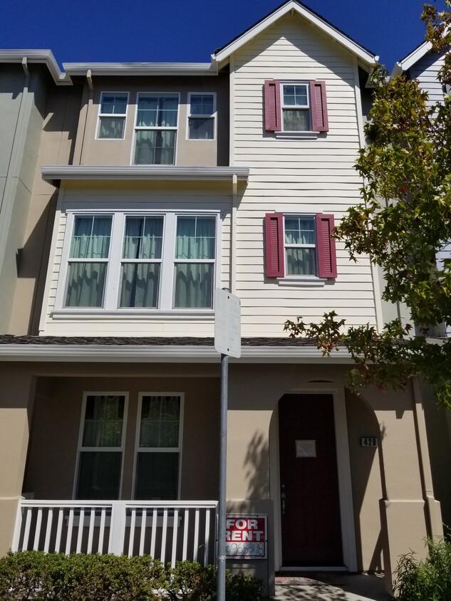
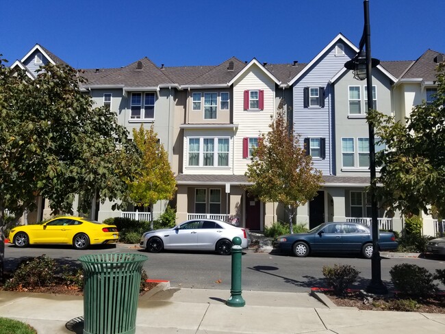
429 Metro Walk Way
Richmond, CA 94801
2 Weeks Ago
Favorites
429 Metro Walk Way

Favorites
Check Back Soon for Upcoming Availability
| Beds | Baths | Average SF |
|---|---|---|
| 3 Bedrooms 3 Bedrooms 3 Br | 3.5 Baths 3.5 Baths 3.5 Ba | 1,643 SF |
Fees and Policies
The fees below are based on community-supplied data and may exclude additional fees and utilities.
- Parking
-
Garage--
About This Property
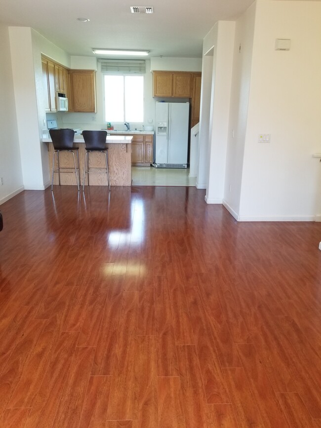
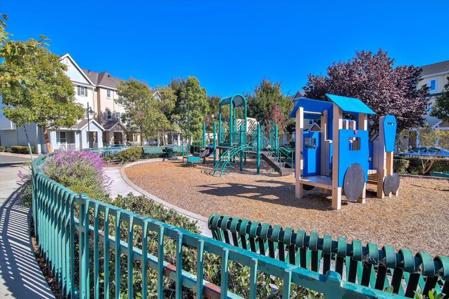
This contemporary Tri-Level Townhouse is built in 2003 with 3 Bedrooms, 3.5 Baths, Sq. Footage 1643, newly paints the whole interior, laminate, and carpet floors. The house is conveniently located in downtown Richmond in a newly developed area with a community park. Conveniently located a few steps from BART, Amtrak, Civic Center, Kaiser, and supermarket. All appliances included (including stove, dishwasher, new washer and dryer, refrigerator, Garbage Disposal, Microwave, and Kitchen Stove). Attached is a two cars garage with remote control, laminate floor, storage spaces, playground in the park, and cable-ready, Central Heating System, Walk-In Closets, close to 580, and 80 freeways. Location: 429 Metro Walk Way, Richmond, CA 94801, Cross Street: Marina Way Move-in requires 1st month's rent plus a $3,400 security deposit. with a one-year lease agreement. Tenant pays all utilities. Credit check, current I.D., and references are required. No pets, no smoking. If interested please call Yu Saw, Please leave a message or text it to me. Rent: $3400.00 Security Deposit: $3400 Move-in Ready by April 9, 2022 (approximately) One year lease
429 Metro Walk Way is a townhome located in Contra Costa County and the 94801 ZIP Code.
Townhome Features
Washer/Dryer
Dishwasher
Walk-In Closets
Microwave
- Washer/Dryer
- Heating
- Smoke Free
- Dishwasher
- Disposal
- Kitchen
- Microwave
- Refrigerator
- Carpet
- Walk-In Closets
- Playground
Location
Get Directions
The Iron Triangle neighborhood sits in the heart of Central Richmond, California. With the area being largely residential, most rentals reside in the upper part of the triangle and an easy three-mile commute north to Point Richmond, a major shipping and industrial area. To the south, Berkeley and Oakland lie roughly 10 miles away via Interstate 580.
Locals often head for the Miller/Knox Regional Shoreline for a bit of jogging or cycling, or to cast a line off the fishing pier. Wade into the waters of San Francisco Bay at Keller Beach on the northern end of the park, or enjoy a show at the Masquers Playhouse, also just outside the Iron Triangle's southern border. Most eateries sit along Interstate 580, including several fast food chains. The MacDonald 80 Shopping Center lies roughly three miles east of the neighborhood. Drive another three miles and find Wildcat Canyon Regional Park and the Tilden Nature Area.
Learn more about living in Iron TriangleBelow are rent ranges for similar nearby apartments
Amenities
- Washer/Dryer
- Heating
- Smoke Free
- Dishwasher
- Disposal
- Kitchen
- Microwave
- Refrigerator
- Carpet
- Walk-In Closets
- Playground
Education
| Colleges & Universities | Distance | ||
|---|---|---|---|
| Colleges & Universities | Distance | ||
| Drive: | 7 min | 3.3 mi | |
| Drive: | 16 min | 9.1 mi | |
| Drive: | 20 min | 10.1 mi | |
| Drive: | 20 min | 12.0 mi |
429 Metro Walk Way is within 7 minutes or 3.3 miles from Contra Costa College. It is also near Berkeley City College and UC Berkeley.
Transportation options available in Richmond include Richmond Station, located 0.2 mile from 429 Metro Walk Way. 429 Metro Walk Way is near Metro Oakland International, located 22.1 miles or 31 minutes away, and San Francisco International, located 29.7 miles or 44 minutes away.
| Transit / Subway | Distance | ||
|---|---|---|---|
| Transit / Subway | Distance | ||
|
|
Walk: | 4 min | 0.2 mi |
|
|
Drive: | 6 min | 2.8 mi |
|
|
Drive: | 6 min | 2.8 mi |
|
|
Drive: | 9 min | 4.9 mi |
|
|
Drive: | 15 min | 8.5 mi |
| Commuter Rail | Distance | ||
|---|---|---|---|
| Commuter Rail | Distance | ||
| Walk: | 3 min | 0.2 mi | |
|
|
Drive: | 12 min | 7.7 mi |
|
|
Drive: | 14 min | 9.5 mi |
| Drive: | 18 min | 10.2 mi | |
| Drive: | 18 min | 11.2 mi |
| Airports | Distance | ||
|---|---|---|---|
| Airports | Distance | ||
|
Metro Oakland International
|
Drive: | 31 min | 22.1 mi |
|
San Francisco International
|
Drive: | 44 min | 29.7 mi |
Time and distance from 429 Metro Walk Way.
| Shopping Centers | Distance | ||
|---|---|---|---|
| Shopping Centers | Distance | ||
| Walk: | 6 min | 0.4 mi | |
| Drive: | 5 min | 2.1 mi | |
| Drive: | 4 min | 2.2 mi |
429 Metro Walk Way has 3 shopping centers within 2.2 miles, which is about a 4-minute walk. The miles and minutes will be for the farthest away property.
| Parks and Recreation | Distance | ||
|---|---|---|---|
| Parks and Recreation | Distance | ||
|
Rosie the Riveter WWII Home Front National Historical Park
|
Drive: | 5 min | 1.9 mi |
|
Marina Park & Green
|
Drive: | 6 min | 2.1 mi |
|
Shimada Friendship Park
|
Drive: | 7 min | 2.9 mi |
|
Miller/Knox Regional Shoreline
|
Drive: | 7 min | 3.1 mi |
|
Brooks Island Regional Preserve
|
Drive: | 11 min | 4.7 mi |
429 Metro Walk Way has 5 parks within 4.7 miles, including Rosie the Riveter WWII Home Front National Historical Park, Marina Park & Green, and Shimada Friendship Park.
| Hospitals | Distance | ||
|---|---|---|---|
| Hospitals | Distance | ||
| Drive: | 19 min | 10.7 mi | |
| Drive: | 16 min | 11.6 mi | |
| Drive: | 17 min | 11.6 mi |
429 Metro Walk Way has 3 hospitals within 11.6 miles, the nearest is Alta Bates Summit Medical Center - Alta Bates Campus which is 10.7 miles away and a 19 minute drive.
| Military Bases | Distance | ||
|---|---|---|---|
| Military Bases | Distance | ||
| Drive: | 7 min | 3.2 mi | |
| Drive: | 12 min | 5.6 mi | |
| Drive: | 25 min | 15.7 mi |
429 Metro Walk Way has 3 military bases within 15.7 miles, the nearest is Armory West Contra Costa which is 3.2 miles away and a 7 minute drive.
You May Also Like
Similar Rentals Nearby
-
-

-
-
-
-
-

-
 $3,3003 Beds, 1 Bath, 1,300 sq ftTownhome for Rent
 -

-


What Are Walk Score®, Transit Score®, and Bike Score® Ratings?
Walk Score® measures the walkability of any address. Transit Score® measures access to public transit. Bike Score® measures the bikeability of any address.
What is a Sound Score Rating?
A Sound Score Rating aggregates noise caused by vehicle traffic, airplane traffic and local sources

429 Metro Walk Way
Richmond, CA 94801