
$1,250
/ Month
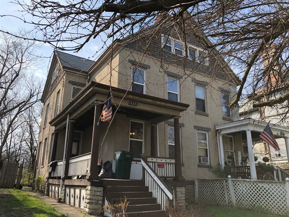
425 Purcell Ave
Cincinnati, OH 45205
2 Weeks Ago
|
Edit
Favorites
425 Purcell Ave

Favorites
Check Back Soon for Upcoming Availability
| Beds | Baths | Average SF |
|---|---|---|
| 6 Bedrooms 6 Bedrooms 6 Br | 2.5 Baths 2.5 Baths 2.5 Ba | 2,344 SF |
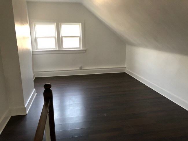
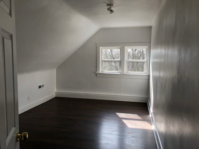
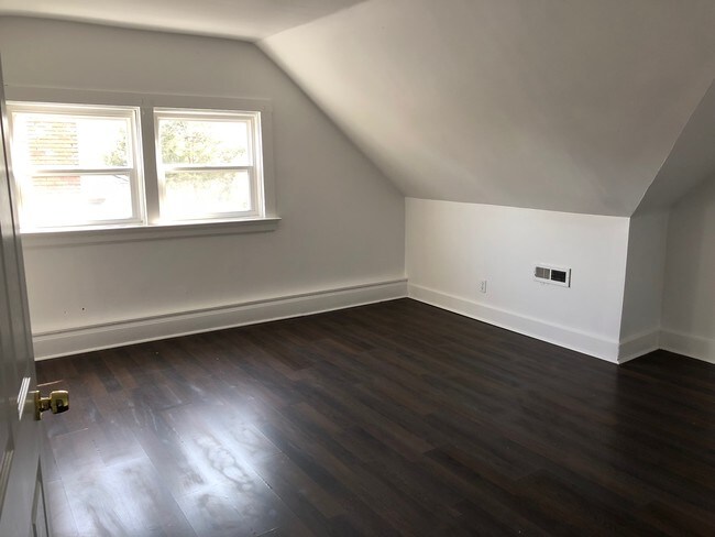
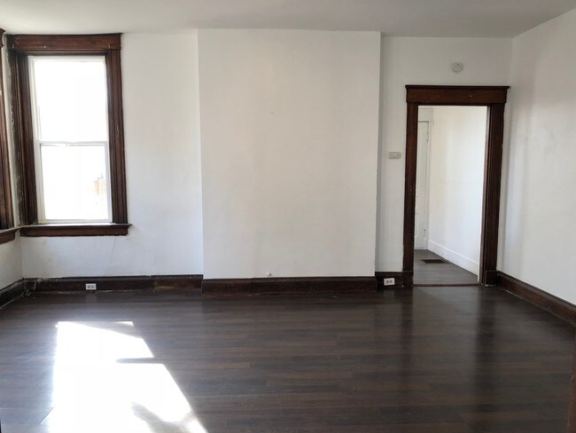
About This Property
This Charming 6 bedroom 2 bath house is a MUST SEE!!!! It is located in the new and up coming East Price Hill Incline District!!!! This home is perfect for your large family!!!! This home has a gorgeous yard with an adorable front porch! Located on a quiet street with everything you need in walking distance. Bus line. THIS IS PRICED RIGHT!!!!
425 Purcell Ave is a house located in Hamilton County and the 45205 ZIP Code. This area is served by the Cincinnati Public Schools attendance zone.
425 Purcell Ave,
Cincinnati,
OH
45205
East Price Hill, conveniently located just about five miles west of downtown Cincinnati, puts residents within easy commuting distance from Cincinnati and the Northern Kentucky area — just a bridge away across the Ohio River. The northeast corner of Price Hill East holds the Warsaw Federal Incline Theater, where locals enjoy live stage plays throughout the summer months. Steps away, across Matson Place, the Incline Public House stays open for dinner seven nights a week to accommodate theater-goers.
Price Hill East sits just to the northeast of Embshoff Woods and Nature Preserve, where locals enjoy several amenities including a nine-hole disc golf course, a one-mile Parkour fitness path, a children’s playground, and shelters for picnics. Outdoor enthusiasts can find apartments for rent near the 84-acre Mt. Echo Park, with its popular Mt. Echo pavilion, where visitors enjoy panoramic views of the Ohio River valley and downtown Cincinnati.
Learn more about living in East Price HillBelow are rent ranges for similar nearby apartments
Education
| Colleges & Universities | Distance | ||
|---|---|---|---|
| Colleges & Universities | Distance | ||
| Drive: | 12 min | 5.0 mi | |
| Drive: | 13 min | 6.6 mi | |
| Drive: | 14 min | 6.6 mi | |
| Drive: | 13 min | 6.9 mi |
425 Purcell Ave is within 12 minutes or 5.0 miles from College of Mount St. Joseph. It is also near University of Cincinnati and Cincinnati State.
Schools


Public Elementary School
Grades PK-5
Attendance Zone
Public Middle & High School
Grades 6-12
Attendance Zone
Public Middle & High School
Grades 6-12
Attendance Zone
Public Middle & High School
Grades 6-12
Attendance Zone
Private Elementary, Middle & High School
Grades K-12
Nearby
Private Elementary, Middle & High School
Grades K-12
Nearby
Private Elementary & Middle School
Grades PK-8
Nearby
School data provided by
 The GreatSchools Rating helps parents compare schools within a state based on a variety of school quality indicators and provides a helpful picture of how effectively each school serves all of its students. Ratings are on a scale of 1 (below average) to 10 (above average) and can include test scores, college readiness, academic progress, advanced courses, equity, discipline and attendance data. We also advise parents to visit schools, consider other information on school performance and programs, and consider family needs as part of the school selection process.
View GreatSchools Rating Methodology
Data provided by GreatSchools.org © 2026. All rights reserved.
View GreatSchools Rating Methodology
Data provided by GreatSchools.org © 2026. All rights reserved.
Transportation options available in Cincinnati include 14Th & Elm Station, located 3.7 miles from 425 Purcell Ave. 425 Purcell Ave is near Cincinnati/Northern Kentucky International, located 16.2 miles or 30 minutes away.
| Transit / Subway | Distance | ||
|---|---|---|---|
| Transit / Subway | Distance | ||
| Drive: | 8 min | 3.7 mi | |
| Drive: | 8 min | 3.9 mi | |
| Drive: | 9 min | 3.9 mi | |
| Drive: | 9 min | 4.1 mi | |
| Drive: | 9 min | 4.3 mi |
| Commuter Rail | Distance | ||
|---|---|---|---|
| Commuter Rail | Distance | ||
|
|
Drive: | 8 min | 3.3 mi |
| Airports | Distance | ||
|---|---|---|---|
| Airports | Distance | ||
|
Cincinnati/Northern Kentucky International
|
Drive: | 30 min | 16.2 mi |
Walkability Near 425 Purcell Ave Cincinnati, OH 45205
Getting Around
 What do Walkability, Transit, Drivability, and Bikeability mean?
Walkability measures the walking distance to day-to-day needs.
Transit measures access to public transportation.
Drivability measures congestion, parking availability, and access to major roads.
Bikeability measures the suitability for cycling.
How It Works
What do Walkability, Transit, Drivability, and Bikeability mean?
Walkability measures the walking distance to day-to-day needs.
Transit measures access to public transportation.
Drivability measures congestion, parking availability, and access to major roads.
Bikeability measures the suitability for cycling.
How It Works
Fairly Walkable
Walkability
40
/ 100
Limited Public Transit
Transit
30
/ 100
Very Drivable
Drivability
80
/ 100
Somewhat Bikeable
Bikeability
30
/ 100
Scores provided by
Active
Soundscore™
78
/ 100
Traffic
ActiveAirport
CalmBusinesses
CalmScores provided by
HowLoud What is a Sound Score Rating? A Sound Score Rating aggregates noise caused by vehicle traffic, airplane traffic and local sources. How It WorksTime and distance from 425 Purcell Ave.
| Shopping Centers | Distance | ||
|---|---|---|---|
| Shopping Centers | Distance | ||
| Walk: | 18 min | 1.0 mi | |
| Walk: | 19 min | 1.0 mi | |
| Drive: | 6 min | 2.4 mi |
425 Purcell Ave has 3 shopping centers within 2.4 miles, which is about a 6-minute drive. The miles and minutes will be for the farthest away property.
| Parks and Recreation | Distance | ||
|---|---|---|---|
| Parks and Recreation | Distance | ||
|
Wilson Commons
|
Walk: | 9 min | 0.5 mi |
|
Imago Earth Center
|
Drive: | 3 min | 1.1 mi |
|
Embshoff Woods
|
Drive: | 8 min | 2.7 mi |
|
Museum of Natural History and Science
|
Drive: | 8 min | 3.3 mi |
|
Cincinnati History Museum
|
Drive: | 8 min | 3.3 mi |
425 Purcell Ave has 5 parks within 3.3 miles, including Wilson Commons, Imago Earth Center, and Embshoff Woods.
| Hospitals | Distance | ||
|---|---|---|---|
| Hospitals | Distance | ||
| Drive: | 11 min | 5.8 mi | |
| Drive: | 11 min | 6.1 mi | |
| Drive: | 12 min | 6.6 mi |
425 Purcell Ave has 3 hospitals within 6.6 miles, the nearest is Good Samaritan Hospital which is 5.8 miles away and a 11 minute drive.
| Military Bases | Distance | ||
|---|---|---|---|
| Military Bases | Distance | ||
| Drive: | 75 min | 57.0 mi | |
| Drive: | 81 min | 62.0 mi | |
| Drive: | 84 min | 65.3 mi |
425 Purcell Ave has 3 military bases within 65.3 miles, the nearest is Gentile Air Force Station which is 57.0 miles away and a 75 minute drive.
You May Also Like
Similar Rentals Nearby
-
-
 4 Beds$2,355Total Monthly PriceTotal Monthly Price NewPrices include all required monthly fees.House for Rent
 -
 4 Beds$2,695Total Monthly PriceTotal Monthly Price NewPrices include all required monthly fees.House for Rent
 -
 5 Beds$2,840Total Monthly PriceTotal Monthly Price NewPrices include all required monthly fees.House for Rent
 -
 4 Beds$2,710Total Monthly PriceTotal Monthly Price NewPrices include all required monthly fees.House for Rent
 -
 4 Beds$2,515Total Monthly PriceTotal Monthly Price NewPrices include all required monthly fees.House for Rent
 -
 4 Beds$2,700Total Monthly PriceTotal Monthly Price NewPrices include all required monthly fees.House for Rent
 -
 4 Beds$2,745Total Monthly PriceTotal Monthly Price NewPrices include all required monthly fees.House for Rent
 -
 4 Beds$2,275Total Monthly PriceTotal Monthly Price NewPrices include all required monthly fees.House for Rent
 -
 4 Beds$2,505Total Monthly PriceTotal Monthly Price NewPrices include all required monthly fees.House for Rent

What Are Walk Score®, Transit Score®, and Bike Score® Ratings?
Walk Score® measures the walkability of any address. Transit Score® measures access to public transit. Bike Score® measures the bikeability of any address.
What is a Sound Score Rating?
A Sound Score Rating aggregates noise caused by vehicle traffic, airplane traffic and local sources.
425 Purcell Ave
Cincinnati, OH 45205