
$1,600 / Month
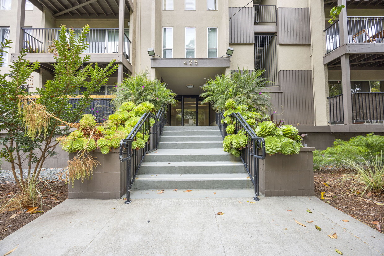
425 Orange St
Oakland, CA 94610
Today
Favorites
510-410-6103
-
Bedrooms
Studio
-
Bathrooms
1
-
Square Feet
373 sq ft
-
Available
Available Now
425 Orange St

Favorites
About This Home
$1,600 deposit,
Available Now
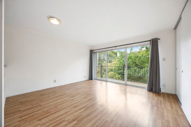
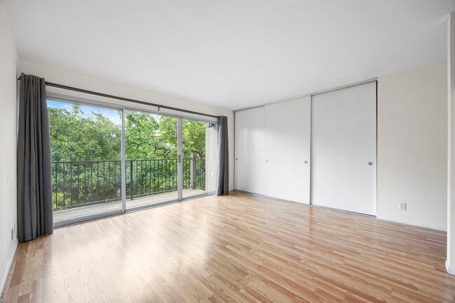
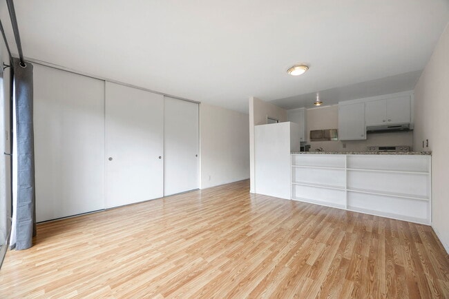
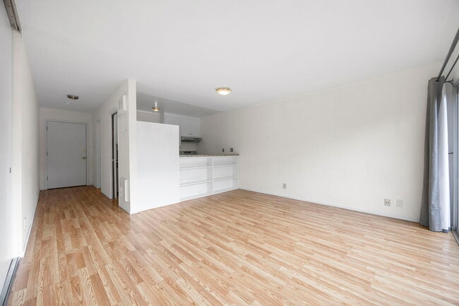
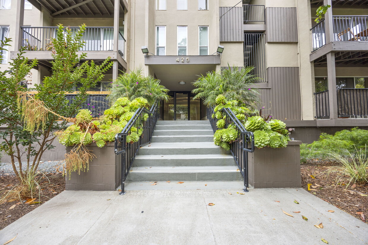
POOL TIME! Summer is heating up - don't you want to be the "friend with a pool"? 425 Orange Street is a condo development at the top of Adams Point with a pool, gated community, and underground parking! This is an updated studio unit on top floor available in a great location! Halfway between Grand Lake shopping and Piedmont Ave, this well appointed studio is available now! You even have your own deck with downtown Oakland views! Featuring: *Lovely and warm updated hardwood laminate throughout *Updated appliances, including dishwasher and electric range w/ hood *Updated bathroom including tiled shower over tub and tile floor *Private balcony with views of downtown Oakland and Oakland hills *Top floor unit *Large closet space that spans the living space, including built in shelves *Super close to Lake Merritt (.8mi), Lakeshore/Grand shopping and restaurants (.7mi) and Piedmont Ave (.5 mi)! Get to Whole Foods, Downtown, Public Transportation easily *Convenient 580 FWY access to all areas of the East Bay and SF! *PARKING INCLUDED! NO extra cost! Rent includes: Water, Garbage, Designated Garage Parking Space and Sewer. Security Deposit: $1600. Coin-Op Laundry On Site. No Pets. No Smoking. Online applications available, $30 to apply, email for application. First months rent plus security deposit due at move in. Email is best for appointment or open house times.
425 Orange St is a townhome located in Alameda County and the 94610 ZIP Code. This area is served by the Oakland Unified attendance zone.
* Price shown is base rent and may not include non-optional fees and utilities.
Price, availability, fees, and any applicable rent special are subject to change without notice.
* Square footage definitions vary. Displayed square footage is approximate.
Townhome Features
Dishwasher
Microwave
Refrigerator
Range
- Dishwasher
- Microwave
- Range
- Refrigerator
- Balcony
Fees and Policies
The fees below are based on community-supplied data and may exclude additional fees and utilities.
- Parking
-
Garage--
Contact
- Listed by Pamela Neher
- Phone Number
- Contact
Location
Get Directions
Amenities
- Dishwasher
- Microwave
- Range
- Refrigerator
- Balcony
Settled into the low hills of North Oakland lies the Oakland Avenue-Harrison Street neighborhood, often called HarriOak or Westlake by the locals. With streets lined with established trees and comfortably sized homes, HarriOak serves as a popular choice with young professionals and families. A decidedly residential neighborhood, this area sits just moments away from a strong business corridors along Broadway while remaining tucked away from the bustle.
This close-knit neighborhood runs an active block watch to keep the area safer. Many streets host block parties and homeowners share produce from their home gardens with neighbors. Residents enjoy close proximity to major employer Kaiser Permanente and an easy 2-mile commute to Downtown Oakland and a 4-mile commute north to the UC Berkeley campus.
Learn more about living in Westlake
Education
| Colleges & Universities | Distance | ||
|---|---|---|---|
| Colleges & Universities | Distance | ||
| Walk: | 16 min | 0.8 mi | |
| Drive: | 5 min | 1.5 mi | |
| Drive: | 6 min | 2.6 mi | |
| Drive: | 9 min | 3.6 mi |
425 Orange St is within 16 minutes or 0.8 mile from Samuel Merritt University. It is also near Lincoln University, Oakland and Laney College.
Schools


Public Elementary School
Grades K-5
332 Students
Attendance Zone
Public Elementary School
Grades K-5
347 Students
Nearby
Public Middle School
Grades 6-8
314 Students
Attendance Zone
Public High School
Grades 9-12
1,796 Students
Attendance Zone
Private Elementary School
Grades PK-5
160 Students
Nearby
Private Elementary & Middle School
Grades K-8
Nearby
Private Elementary, Middle & High School
Grades 4-12
Nearby
Private Elementary & Middle School
Grades PK-8
237 Students
Nearby
School data provided by
 The GreatSchools Rating helps parents compare schools within a state based on a variety of school quality indicators and provides a helpful picture of how effectively each school serves all of its students. Ratings are on a scale of 1 (below average) to 10 (above average) and can include test scores, college readiness, academic progress, advanced courses, equity, discipline and attendance data. We also advise parents to visit schools, consider other information on school performance and programs, and consider family needs as part of the school selection process.
View GreatSchools Rating Methodology
Data provided by GreatSchools.org © 2025. All rights reserved.
View GreatSchools Rating Methodology
Data provided by GreatSchools.org © 2025. All rights reserved.
Transportation options available in Oakland include 19Th St Oakland Station, located 1.2 miles from 425 Orange St. 425 Orange St is near Metro Oakland International, located 10.3 miles or 17 minutes away, and San Francisco International, located 22.8 miles or 34 minutes away.
| Transit / Subway | Distance | ||
|---|---|---|---|
| Transit / Subway | Distance | ||
|
|
Drive: | 3 min | 1.2 mi |
|
|
Drive: | 4 min | 1.5 mi |
|
|
Drive: | 4 min | 1.6 mi |
|
|
Drive: | 4 min | 2.0 mi |
|
|
Drive: | 7 min | 3.8 mi |
| Commuter Rail | Distance | ||
|---|---|---|---|
| Commuter Rail | Distance | ||
|
|
Drive: | 6 min | 2.4 mi |
|
|
Drive: | 6 min | 3.8 mi |
|
|
Drive: | 9 min | 5.9 mi |
| Drive: | 15 min | 10.3 mi | |
| Drive: | 16 min | 10.4 mi |
| Airports | Distance | ||
|---|---|---|---|
| Airports | Distance | ||
|
Metro Oakland International
|
Drive: | 17 min | 10.3 mi |
|
San Francisco International
|
Drive: | 34 min | 22.8 mi |
Time and distance from 425 Orange St.
| Shopping Centers | Distance | ||
|---|---|---|---|
| Shopping Centers | Distance | ||
| Walk: | 12 min | 0.7 mi | |
| Drive: | 3 min | 1.2 mi | |
| Drive: | 3 min | 1.4 mi |
425 Orange St has 3 shopping centers within 1.4 miles, which is about a 3-minute walk. The miles and minutes will be for the farthest away property.
| Parks and Recreation | Distance | ||
|---|---|---|---|
| Parks and Recreation | Distance | ||
|
Morcom Rose Garden
|
Walk: | 11 min | 0.6 mi |
|
Lakeside Park
|
Walk: | 15 min | 0.8 mi |
|
Rotary Nature Center
|
Drive: | 2 min | 1.2 mi |
|
Lakeside Park Garden Center
|
Drive: | 2 min | 1.2 mi |
|
Juan Bautista de Anza National Historic Trail
|
Drive: | 5 min | 1.6 mi |
425 Orange St has 5 parks within 1.6 miles, including Morcom Rose Garden, Lakeside Park, and Rotary Nature Center.
| Hospitals | Distance | ||
|---|---|---|---|
| Hospitals | Distance | ||
| Walk: | 11 min | 0.6 mi | |
| Walk: | 15 min | 0.8 mi | |
| Drive: | 4 min | 2.1 mi |
425 Orange St has 3 hospitals within 2.1 miles, the nearest is Kaiser Foundation Hospital - Oakland / Richmond which is 0.6 mile away and a 11 minute walk.
| Military Bases | Distance | ||
|---|---|---|---|
| Military Bases | Distance | ||
| Drive: | 13 min | 5.1 mi | |
| Drive: | 13 min | 6.3 mi |
425 Orange St is 5.1 miles from Alameda/US Naval Air Station Alameda, and is convenient to other military bases, including Oakland Army Base.
You May Also Like
Similar Rentals Nearby


What Are Walk Score®, Transit Score®, and Bike Score® Ratings?
Walk Score® measures the walkability of any address. Transit Score® measures access to public transit. Bike Score® measures the bikeability of any address.
What is a Sound Score Rating?
A Sound Score Rating aggregates noise caused by vehicle traffic, airplane traffic and local sources
425 Orange St
Oakland, CA 94610