
$3,100
Total Monthly Price
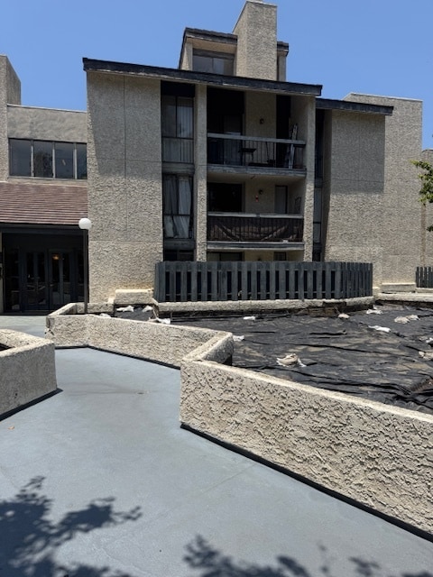
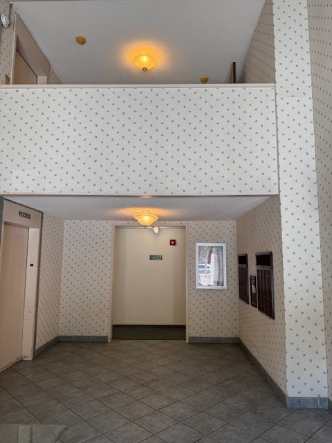
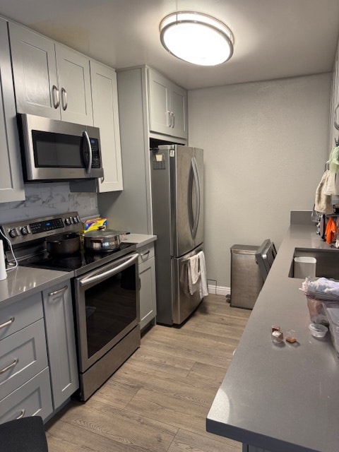
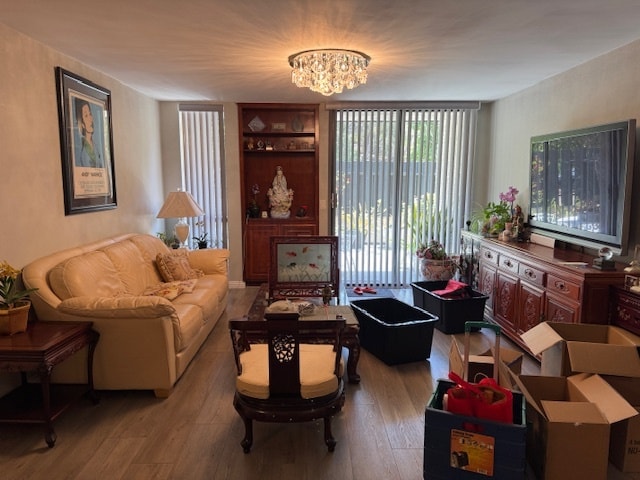
4239 Via Arbolada Unit 101
Los Angeles, CA 90042
1 Week Ago
|
Edit
Favorites
626-699-9426
-
Bedrooms
2
-
Bathrooms
2
-
Square Feet
1,023 sq ft
-
Available
Available Now
Highlights
- Room for Rent
- Pets Allowed
4239 Via Arbolada Unit 101

Favorites
About This Home
12 Month Lease,
$3,100 deposit,
Available Now
Monterey Hill, Los Angeles.........................................................
4239 Via Arbolada is a condo located in Los Angeles County and the 90042 ZIP Code. This area is served by the Los Angeles Unified attendance zone.
* Price shown is total price based on community-supplied monthly required fees. Excludes user-selected optional fees and variable or usage-based fees and required charges due at or prior to move-in or at move-out. Price, availability, fees, and any applicable rent special are subject to change without notice.
* Square footage definitions vary. Displayed square footage is approximate.
Condo Features
- Washer/Dryer
- Air Conditioning
- Dishwasher
- Elevator
Fees and Policies
The fees listed below are community-provided and may exclude utilities or add-ons. All payments are made directly to the property and are non-refundable unless otherwise specified.
- Dogs Allowed
-
Fees not specified
- Cats Allowed
-
Fees not specified
- Parking
-
Garage--
Details
Utilities Included
-
Water
-
Trash Removal
Property Information
-
Built in 1982
Contact
- Phone Number
- Contact
Location
Get Directions
A quiet suburb outside of Los Angeles, Monterey Hills is known for its rolling hills, winding residential streets, and elevated city views. Check out Elephant Hill, a popular place to bike or hike that offers beautiful views of the neighborhood. Herman Park is nestled along Highway 110 in the north end of the neighborhood, offering tennis courts, playgrounds, and a dog park. And for more outdoor recreation, visit the biking paths and hiking trails at Ernest E. Debs Regional Park, bordering Monterey Hills.
Monterey Hills is a more secluded part of Northeast Los Angeles with larger lots, single-family homes, and tree-lined streets. However, if you cross over Highway 110, you’ll find theatres, restaurants, services, and more. Monterey Hills is located just seven miles northeast of Downtown Los Angeles and eight miles east of major attractions such as Griffith Park, the Los Angeles Zoo, the Greek Theatre, and Glendale Galleria.
Learn more about living in Monterey Hills
Education
| Colleges & Universities | Distance | ||
|---|---|---|---|
| Colleges & Universities | Distance | ||
| Drive: | 9 min | 3.9 mi | |
| Drive: | 11 min | 4.2 mi | |
| Drive: | 11 min | 4.2 mi | |
| Drive: | 9 min | 4.6 mi |
4239 Via Arbolada Unit 101 is within 11 minutes or 4.2 miles from Cal State Los Angeles. It is also near USC, Health Sciences Campus and Occidental College.
Schools


Public Elementary School
Grades K-5
157 Students
Attendance Zone
Public Elementary School
Grades K-6
222 Students
Attendance Zone
Charter Elementary School
Grades K-5
75 Students
Nearby
Public Middle School
Grades 6-8
857 Students
Attendance Zone
Public Middle School
Grades 6-8
824 Students
Attendance Zone
Public High School
Grades 9-12
1,260 Students
Attendance Zone
Public High School
Grades 9-12
913 Students
Attendance Zone
Private Elementary & Middle School
Grades PK-8
92 Students
Nearby
Private Elementary, Middle & High School
Grades K-12
Nearby
Private Elementary & Middle School
Grades K-5 & 8
89 Students
Nearby
School data provided by
 The GreatSchools Rating helps parents compare schools within a state based on a variety of school quality indicators and provides a helpful picture of how effectively each school serves all of its students. Ratings are on a scale of 1 (below average) to 10 (above average) and can include test scores, college readiness, academic progress, advanced courses, equity, discipline and attendance data. We also advise parents to visit schools, consider other information on school performance and programs, and consider family needs as part of the school selection process.
View GreatSchools Rating Methodology
Data provided by GreatSchools.org © 2026. All rights reserved.
View GreatSchools Rating Methodology
Data provided by GreatSchools.org © 2026. All rights reserved.
Transportation options available in Los Angeles include Highland Park Station, located 2.1 miles from 4239 Via Arbolada Unit 101. 4239 Via Arbolada Unit 101 is near Bob Hope, located 18.5 miles or 28 minutes away, and Los Angeles International, located 21.5 miles or 35 minutes away.
| Transit / Subway | Distance | ||
|---|---|---|---|
| Transit / Subway | Distance | ||
|
|
Drive: | 6 min | 2.1 mi |
|
|
Drive: | 8 min | 3.2 mi |
|
|
Drive: | 8 min | 3.5 mi |
|
|
Drive: | 7 min | 3.6 mi |
|
|
Drive: | 8 min | 4.3 mi |
| Commuter Rail | Distance | ||
|---|---|---|---|
| Commuter Rail | Distance | ||
|
|
Drive: | 13 min | 5.4 mi |
|
|
Drive: | 12 min | 5.5 mi |
|
|
Drive: | 14 min | 7.8 mi |
| Drive: | 15 min | 9.4 mi | |
|
|
Drive: | 21 min | 10.2 mi |
| Airports | Distance | ||
|---|---|---|---|
| Airports | Distance | ||
|
Bob Hope
|
Drive: | 28 min | 18.5 mi |
|
Los Angeles International
|
Drive: | 35 min | 21.5 mi |
Time and distance from 4239 Via Arbolada Unit 101.
| Shopping Centers | Distance | ||
|---|---|---|---|
| Shopping Centers | Distance | ||
| Drive: | 5 min | 1.9 mi | |
| Drive: | 6 min | 2.4 mi | |
| Drive: | 6 min | 2.5 mi |
4239 Via Arbolada Unit 101 has 3 shopping centers within 2.5 miles, which is about a 6-minute drive. The miles and minutes will be for the farthest away property.
| Parks and Recreation | Distance | ||
|---|---|---|---|
| Parks and Recreation | Distance | ||
|
Audubon Center at Debs Park
|
Drive: | 6 min | 2.5 mi |
|
Chavez Ravine Arboretum
|
Drive: | 11 min | 6.2 mi |
|
Elysian Park
|
Drive: | 14 min | 6.3 mi |
|
Elyria Canyon Park
|
Drive: | 13 min | 6.5 mi |
|
Marsh Park
|
Drive: | 14 min | 6.8 mi |
4239 Via Arbolada Unit 101 has 5 parks within 6.8 miles, including Audubon Center at Debs Park, Elyria Canyon Park, and Elysian Park.
| Hospitals | Distance | ||
|---|---|---|---|
| Hospitals | Distance | ||
| Drive: | 8 min | 3.6 mi | |
| Drive: | 9 min | 3.7 mi | |
| Drive: | 9 min | 4.4 mi |
4239 Via Arbolada Unit 101 has 3 hospitals within 4.4 miles, the nearest is Keck Hospital of USC which is 3.6 miles away and a 8 minute drive.
| Military Bases | Distance | ||
|---|---|---|---|
| Military Bases | Distance | ||
| Drive: | 32 min | 23.1 mi | |
| Drive: | 43 min | 27.1 mi |
4239 Via Arbolada Unit 101 is 23.1 miles from Los Angeles Air Force Base, and is convenient to other military bases, including Los Alamitos Army Airfield.
Amenities
- Washer/Dryer
- Air Conditioning
- Dishwasher
- Elevator
4239 Via Arbolada Unit 101 Photos
What Are Walk Score®, Transit Score®, and Bike Score® Ratings?
Walk Score® measures the walkability of any address. Transit Score® measures access to public transit. Bike Score® measures the bikeability of any address.
What is a Sound Score Rating?
A Sound Score Rating aggregates noise caused by vehicle traffic, airplane traffic and local sources

4239 Via Arbolada
Los Angeles, CA 90042