
$3,500
/ Month
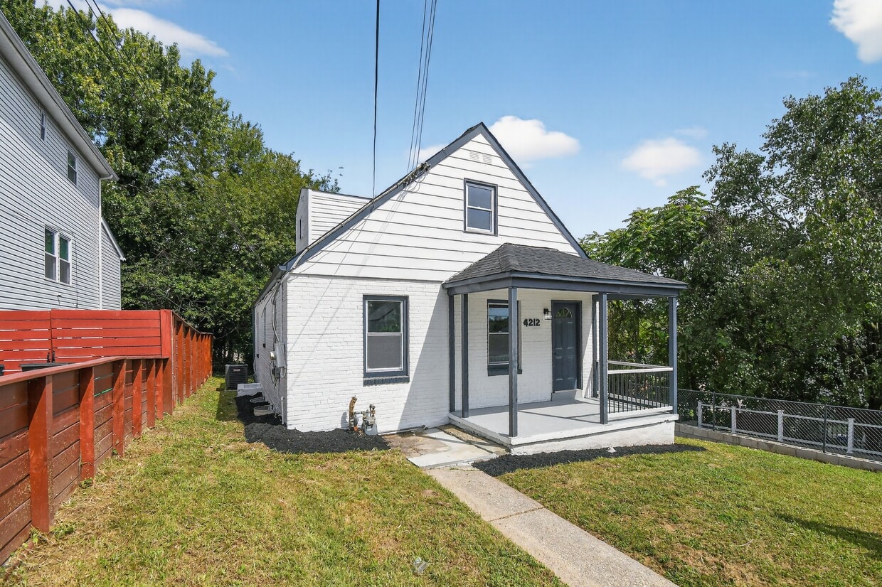
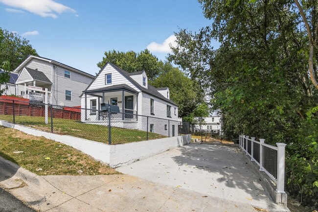
4212 Byers St
Capitol Heights, MD 20743
Today
|
Edit
Favorites
301-655-3593
-
Bedrooms
6
-
Bathrooms
3
-
Square Feet
6,000 sq ft
-
Available
Available Now
4212 Byers St

Favorites
About This Home
$3,500 deposit,
Available Now
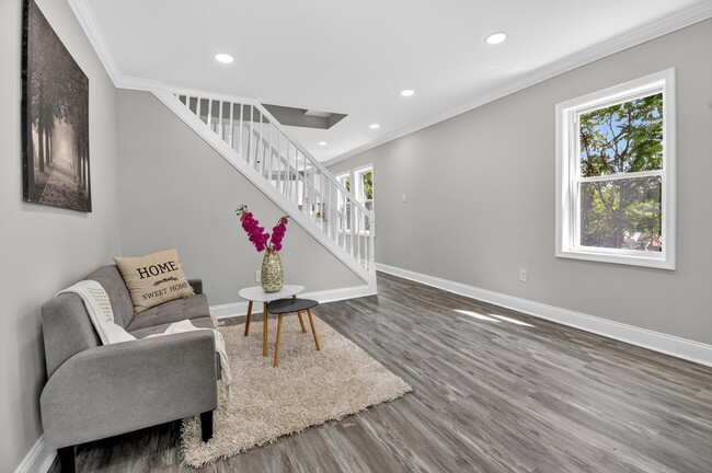
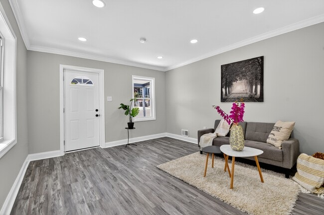
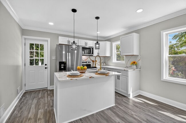
Charming Cape Cod-style house with modern upgrades: Don't miss this spacious and beautiful renovated Cape Cod-style house with 6 bedrooms and 3 bathrooms, located just minutes from Washington, D.C. With new windows, new roof, and recessed lighting throughout, this house features a modern kitchen with elegant quartz countertops and stainless steel appliances. The fully finished basement with 2 bedrooms and potential kitchen is also accessible via a rear entrance , offers incredible flexibility. Located in a highly desirable location with easy access to major transportation routes, shops, restaurants, and more. A unique opportunity that combines space, style, and location!
4212 Byers St is a house located in Prince George's County and the 20743 ZIP Code. This area is served by the Prince George's County Public Schools attendance zone.
* Price shown is base rent. Excludes user-selected optional fees and variable or usage-based fees and required charges due at or prior to move-in or at move-out. Price, availability, fees, and any applicable rent special are subject to change without notice.
* Square footage definitions vary. Displayed square footage is approximate.
Fees and Policies
The fees below are based on community-supplied data and may exclude additional fees and utilities.
- One-Time Basics
- Due at Move-In
- Security Deposit - Refundable$3,500
- Due at Move-In
Property Fee Disclaimer: Based on community-supplied data and independent market research. Subject to change without notice. May exclude fees for mandatory or optional services and usage-based utilities.
House Features
- Dishwasher
Contact
- Listed by Iremia Ocsa
- Phone Number
- Contact
Location
Get Directions
Amenities
- Dishwasher
Coral Hills is a neighborhood in Prince George’s County less than 10 miles from Washington, DC. The neighborhood is accessible to the country’s capital via State Route 4 or public transportation. Coral Hills is largely residential featuring different styles of moderately-priced rentals. The other parts of Coral Hills provide shopping plazas, especially along Marlboro Pike, as well as parks and community amenities like the John Eager Howard Community Center.
Learn more about living in Coral Hills
Education
| Colleges & Universities | Distance | ||
|---|---|---|---|
| Colleges & Universities | Distance | ||
| Drive: | 12 min | 5.7 mi | |
| Drive: | 12 min | 5.9 mi | |
| Drive: | 12 min | 5.9 mi | |
| Drive: | 13 min | 7.1 mi |
4212 Byers St is within 12 minutes or 5.9 miles from Georgetown. It is also near Georgetown Law and Gallaudet University.
Schools

Public Elementary School
Grades PK-6
444 Students
Attendance Zone
Public High School
Grades 9-12
1,834 Students
Attendance Zone
Private Elementary & Middle School
Grades PK-8
156 Students
Nearby
Private Elementary & Middle School
Grades PK-8
130 Students
Nearby
Private Elementary, Middle & High School
Grades PK-12
35 Students
Nearby
School data provided by
 The GreatSchools Rating helps parents compare schools within a state based on a variety of school quality indicators and provides a helpful picture of how effectively each school serves all of its students. Ratings are on a scale of 1 (below average) to 10 (above average) and can include test scores, college readiness, academic progress, advanced courses, equity, discipline and attendance data. We also advise parents to visit schools, consider other information on school performance and programs, and consider family needs as part of the school selection process.
View GreatSchools Rating Methodology
Data provided by GreatSchools.org © 2025. All rights reserved.
View GreatSchools Rating Methodology
Data provided by GreatSchools.org © 2025. All rights reserved.
Transportation options available in Capitol Heights include Benning Road, located 2.1 miles from 4212 Byers St. 4212 Byers St is near Ronald Reagan Washington Ntl, located 9.5 miles or 19 minutes away, and Baltimore/Washington International Thurgood Marshall, located 30.7 miles or 47 minutes away.
| Transit / Subway | Distance | ||
|---|---|---|---|
| Transit / Subway | Distance | ||
|
|
Drive: | 5 min | 2.1 mi |
|
|
Drive: | 5 min | 2.2 mi |
|
|
Drive: | 8 min | 2.4 mi |
|
Capitol Heights, Blue/Silver Line Center Platform
|
Drive: | 6 min | 2.6 mi |
|
|
Drive: | 8 min | 3.4 mi |
| Commuter Rail | Distance | ||
|---|---|---|---|
| Commuter Rail | Distance | ||
|
|
Drive: | 11 min | 5.5 mi |
|
|
Drive: | 11 min | 5.5 mi |
|
|
Drive: | 11 min | 5.9 mi |
|
|
Drive: | 12 min | 6.1 mi |
|
|
Drive: | 16 min | 8.2 mi |
| Airports | Distance | ||
|---|---|---|---|
| Airports | Distance | ||
|
Ronald Reagan Washington Ntl
|
Drive: | 19 min | 9.5 mi |
|
Baltimore/Washington International Thurgood Marshall
|
Drive: | 47 min | 30.7 mi |
Time and distance from 4212 Byers St.
| Shopping Centers | Distance | ||
|---|---|---|---|
| Shopping Centers | Distance | ||
| Walk: | 15 min | 0.8 mi | |
| Drive: | 2 min | 1.2 mi | |
| Drive: | 3 min | 1.2 mi |
4212 Byers St has 3 shopping centers within 1.2 miles, which is about a 3-minute walk. The miles and minutes will be for the farthest away property.
| Parks and Recreation | Distance | ||
|---|---|---|---|
| Parks and Recreation | Distance | ||
|
Fort Dupont Park
|
Drive: | 4 min | 1.4 mi |
|
Suitland Bog
|
Drive: | 7 min | 3.2 mi |
|
Oxon Cove Park
|
Drive: | 8 min | 3.5 mi |
|
Frederick Douglass National Historic Site
|
Drive: | 9 min | 3.6 mi |
|
Kingman and Heritage Island Park
|
Drive: | 8 min | 3.9 mi |
4212 Byers St has 5 parks within 3.9 miles, including Fort Dupont Park, Suitland Bog, and Oxon Cove Park.
| Hospitals | Distance | ||
|---|---|---|---|
| Hospitals | Distance | ||
| Drive: | 10 min | 4.1 mi | |
| Drive: | 10 min | 4.2 mi | |
| Drive: | 12 min | 5.9 mi |
4212 Byers St has 3 hospitals within 5.9 miles, the nearest is St. Elizabeth's Hospital which is 4.1 miles away and a 10 minute drive.
| Military Bases | Distance | ||
|---|---|---|---|
| Military Bases | Distance | ||
| Drive: | 10 min | 4.3 mi | |
| Drive: | 12 min | 5.1 mi |
4212 Byers St is 4.3 miles from Washington Navy Yard, and is convenient to other military bases, including Anacostia Naval Station.
You May Also Like
Similar Rentals Nearby


What Are Walk Score®, Transit Score®, and Bike Score® Ratings?
Walk Score® measures the walkability of any address. Transit Score® measures access to public transit. Bike Score® measures the bikeability of any address.
What is a Sound Score Rating?
A Sound Score Rating aggregates noise caused by vehicle traffic, airplane traffic and local sources

4212 Byers St
Capitol Heights, MD 20743