
$2,000
/ Month
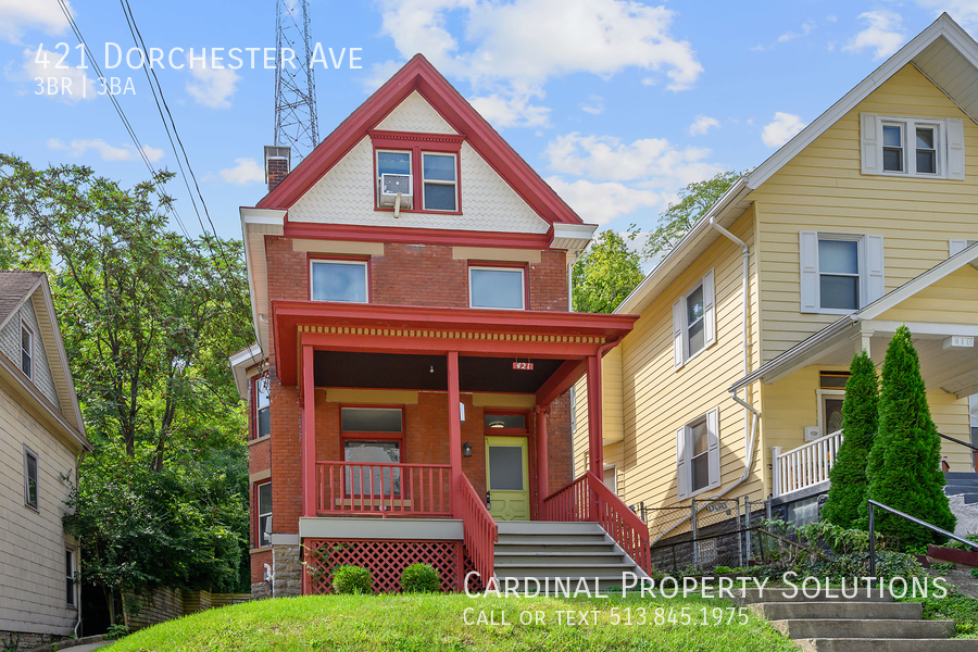
421 Dorchester Ave
Cincinnati, OH 45219
2 Weeks Ago
|
Edit
Favorites
421 Dorchester Ave

Favorites
Check Back Soon for Upcoming Availability
| Beds | Baths | Average SF |
|---|---|---|
| 3 Bedrooms 3 Bedrooms 3 Br | 2.5 Baths 2.5 Baths 2.5 Ba | 1,536 SF |
About This Property
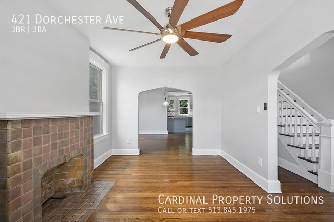
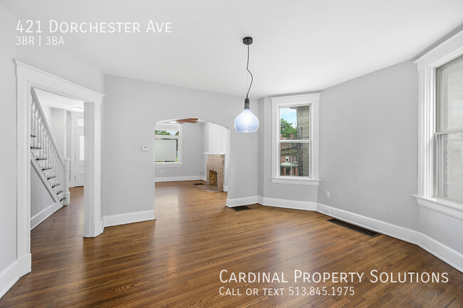
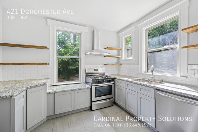
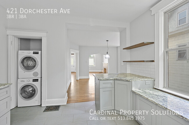
---- SCHEDULE A SHOWING ONLINE AT: ---- This is a beautiful 3 bed & 2.5 bath single family rental. Close proximity to hospitals, UC and OTR. |No Vouchers| Address : 421 Dorchester Avenue - 1 Cincinnati, OH 45219 Amenities: Updated kitchen and baths with primary bedroom featuring an en suite bath. A/C Dryer & Washer First floor laundry Hardwood Floors Partially fenced in backyard and driveway for off-street parking. Utilities: Tenant Responsibilities: Heat, Water Heating, Water, Sewer, Lawn Care and Snow Removal Owner Responsibilities: Trash Lease Terms: Minimum of 12 Months Pets: No CAM Fee: None Security Deposits Options Available! Say goodbye to hefty security deposits! With Obligo, renters enjoy hassle free move-ins. E-mail us at for more information! Insurance and RBP: All Residents are enrolled automatically into a renter's insurance program at $11.95/month to satisfy lease requirements. Upgrade to the premium Resident Benefit Package at $45.00 to receive additional amenities, which includes liability insurance, credit building to help boost the resident's credit score with timely rent payments, up to $1M Identity Theft Protection, HVAC air filter delivery (for applicable properties), move-in concierge service making utility connection and home service setup a breeze during your move-in, our best-in-class resident rewards program, on-demand pest control, and much more! More details upon application. Application Criteria: Minimum credit score 550 Income is 3x of the rent NO Smoking, vaping, or e-cigarettes NO Prior Evictions/Eviction Notice Received NO Bankruptcy NO Violent Criminal History NO more than 2 occupants per bedroom
421 Dorchester Ave is a house located in Hamilton County and the 45219 ZIP Code. This area is served by the Cincinnati Public Schools attendance zone.
Unique Features
- SharedYard
House Features
- Washer/Dryer
- Air Conditioning
Location
Get Directions
The Cincinnati neighborhood of Mount Auburn sits north of downtown and west of Interstate 71. The neighborhood, originally a hilltop escape from the crowded conditions of lower Downtown Cincinnati, gained national recognition as a historic district in 1973. The well-known community contains beautiful mansions dating back to 1819, including the home of former President William Howard Taft.
The community contains beautiful mansions formerly owned by a host of prominent residents. A number of historic buildings and sites dot the area, including the Mount Auburn Young Ladies Institute. The neighborhood also features the beloved ice cream parlor Graeter's Confectionary, as well as Christ Hospital.
Learn more about living in Mount AuburnBelow are rent ranges for similar nearby apartments
| Beds | Average Size | Lowest | Typical | Premium |
|---|---|---|---|---|
| Studio Studio Studio | 536-539 Sq Ft | $650 | $1,233 | $1,901 |
| 1 Bed 1 Bed 1 Bed | 752-756 Sq Ft | $845 | $1,587 | $2,639 |
| 2 Beds 2 Beds 2 Beds | 1094-1101 Sq Ft | $950 | $2,004 | $4,216 |
| 3 Beds 3 Beds 3 Beds | 1416-1427 Sq Ft | $750 | $3,054 | $10,173 |
| 4 Beds 4 Beds 4 Beds | 1938-1947 Sq Ft | $650 | $3,415 | $29,352 |
Amenities
- Washer/Dryer
- Air Conditioning
- SharedYard
Education
| Colleges & Universities | Distance | ||
|---|---|---|---|
| Colleges & Universities | Distance | ||
| Drive: | 5 min | 1.8 mi | |
| Drive: | 5 min | 1.9 mi | |
| Drive: | 9 min | 3.2 mi | |
| Drive: | 12 min | 4.4 mi |
421 Dorchester Ave is within 5 minutes or 1.9 miles from University of Cincinnati. It is also near Univ. of Cincinnati, Medical and Xavier University.
Schools


Public Elementary School
Grades PK-6
236 Students
Attendance Zone
Public Middle & High School
Grades 7-12
1,155 Students
Attendance Zone
Public Middle & High School
Grades 6-12
709 Students
Attendance Zone
Private Elementary & Middle School
Grades PK-8
176 Students
Nearby
Private Elementary, Middle & High School
Grades K-12
131 Students
Nearby
School data provided by
 The GreatSchools Rating helps parents compare schools within a state based on a variety of school quality indicators and provides a helpful picture of how effectively each school serves all of its students. Ratings are on a scale of 1 (below average) to 10 (above average) and can include test scores, college readiness, academic progress, advanced courses, equity, discipline and attendance data. We also advise parents to visit schools, consider other information on school performance and programs, and consider family needs as part of the school selection process.
View GreatSchools Rating Methodology
Data provided by GreatSchools.org © 2025. All rights reserved.
View GreatSchools Rating Methodology
Data provided by GreatSchools.org © 2025. All rights reserved.
Transportation options available in Cincinnati include Hanke Exchange Station, 12Th & Main, located 1.1 miles from 421 Dorchester Ave. 421 Dorchester Ave is near Cincinnati/Northern Kentucky International, located 15.7 miles or 28 minutes away.
| Transit / Subway | Distance | ||
|---|---|---|---|
| Transit / Subway | Distance | ||
| Drive: | 3 min | 1.1 mi | |
| Drive: | 3 min | 1.2 mi | |
| Drive: | 3 min | 1.3 mi | |
| Drive: | 4 min | 1.4 mi | |
| Drive: | 4 min | 1.4 mi |
| Commuter Rail | Distance | ||
|---|---|---|---|
| Commuter Rail | Distance | ||
|
|
Drive: | 7 min | 3.7 mi |
| Airports | Distance | ||
|---|---|---|---|
| Airports | Distance | ||
|
Cincinnati/Northern Kentucky International
|
Drive: | 28 min | 15.7 mi |
Time and distance from 421 Dorchester Ave.
| Shopping Centers | Distance | ||
|---|---|---|---|
| Shopping Centers | Distance | ||
| Drive: | 5 min | 1.8 mi | |
| Drive: | 5 min | 1.8 mi | |
| Drive: | 5 min | 2.5 mi |
421 Dorchester Ave has 3 shopping centers within 2.5 miles, which is about a 5-minute drive. The miles and minutes will be for the farthest away property.
| Parks and Recreation | Distance | ||
|---|---|---|---|
| Parks and Recreation | Distance | ||
|
William H. Taft National Historic Site
|
Walk: | 8 min | 0.5 mi |
|
Krohn Conservatory
|
Walk: | 18 min | 1.0 mi |
|
Eden Park
|
Drive: | 3 min | 1.1 mi |
|
Theodore M. Berry Friendship Park
|
Drive: | 5 min | 2.1 mi |
|
Newport Aquarium
|
Drive: | 5 min | 2.4 mi |
421 Dorchester Ave has 5 parks within 2.4 miles, including William H. Taft National Historic Site, Krohn Conservatory, and Eden Park.
| Hospitals | Distance | ||
|---|---|---|---|
| Hospitals | Distance | ||
| Walk: | 11 min | 0.6 mi | |
| Drive: | 3 min | 1.5 mi | |
| Drive: | 4 min | 1.5 mi |
421 Dorchester Ave has 3 hospitals within 1.5 miles, the nearest is Christ Hospital which is 0.6 mile away and a 11 minute walk.
| Military Bases | Distance | ||
|---|---|---|---|
| Military Bases | Distance | ||
| Drive: | 72 min | 52.5 mi | |
| Drive: | 78 min | 57.5 mi | |
| Drive: | 80 min | 60.8 mi |
421 Dorchester Ave has 3 military bases within 60.8 miles, the nearest is Gentile Air Force Station which is 52.5 miles away and a 72 minute drive.
You May Also Like
Similar Rentals Nearby


What Are Walk Score®, Transit Score®, and Bike Score® Ratings?
Walk Score® measures the walkability of any address. Transit Score® measures access to public transit. Bike Score® measures the bikeability of any address.
What is a Sound Score Rating?
A Sound Score Rating aggregates noise caused by vehicle traffic, airplane traffic and local sources

421 Dorchester Ave
Cincinnati, OH 45219