
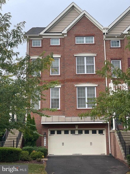
4209 Lariat Way
Upper Marlboro, MD 20772
-
Bedrooms
4
-
Bathrooms
5
-
Square Feet
4,536 sq ft
About This Home
Toll Brothers Bradbury - Williamsburg Model, a Beautiful 4 Bedroom, 3 Full Bath, 2 Half Baths, 2 Car Garage with 50 Amp Car Charger and Solar Panels to save on Electric Bills, 4 Level End-Unit Townhome that lives like a Single Family Home. Never Rented before. Main Level has Living Room/Dining area, Great Room with Fireplace. Kitchen has Granite Countertops, Stainless Steel Appliances, Gas Cooktop. Main Level opens to a large Trex Deck that backs to Woods. The Second Level up has 3 generous Bedrooms. The Primary Suite has His and Hers Walk-in Closets, an Ensuite Bath with Soaking Tub and separate Shower Enclosure. The 2 Secondary Bedrooms share a Full Bath. The Laundry Room is on this Bedroom Level with Oversize Front-Load Washer and Dryer. The Top Level has a Bedroom with Ensuite Full Bath and large Walk-in Closet with Skylights. Outside the Bedroom is a spacious Living area that can be used as a Living Room or Office. The Basement has a Great Room with a Half Bath, Walkout to a Fenced Backyard and Garage access. Garage has 50 Amp Electric Car Charger. The Home has loads of Builder upgrades. Minutes to Joint Base Andrews, University of Maryland Capital Region Medical Center and Prince George County Government Center and Courthouse
4209 Lariat Way is a townhome located in Prince George's County and the 20772 ZIP Code. This area is served by the Prince George's County Public Schools attendance zone.
Townhome Features
- Kitchen
- Refrigerator
Fees and Policies
The fees below are based on community-supplied data and may exclude additional fees and utilities.
Contact
- Kitchen
- Refrigerator
Moving to Upper Marlboro? You’ll be grateful for the close distance to nearby attractions and the sense of pride throughout the community. Located in Prince George’s County, the city is fused with urban and suburban amenities.
There’s much to enjoy about Upper Marlboro, and because it’s more intimate than other surrounding cities, it takes pride in putting on a series of events from homecoming games at local schools to show-stopping performances at the Show Place Arena. Darnall’s Chance House Museum is another city highlight that dates back to 1742.
Shopping in Upper Marlboro reflects the small, quaint ideology of the community. Fresh-baked goods and handmade crafts are purchased at the neighborhood Dutch Village Farmers Market. The distance to Washington D.C. gives residents a choice of either commuting into town by car or Metro rail.
Learn more about living in Upper Marlboro| Colleges & Universities | Distance | ||
|---|---|---|---|
| Colleges & Universities | Distance | ||
| Drive: | 15 min | 6.4 mi | |
| Drive: | 16 min | 8.2 mi | |
| Drive: | 29 min | 14.1 mi | |
| Drive: | 29 min | 15.1 mi |


View GreatSchools Rating Methodology
Transportation options available in Upper Marlboro include Morgan Boulevard, located 7.1 miles from 4209 Lariat Way. 4209 Lariat Way is near Ronald Reagan Washington Ntl, located 18.7 miles or 37 minutes away, and Baltimore/Washington International Thurgood Marshall, located 33.2 miles or 52 minutes away.
| Transit / Subway | Distance | ||
|---|---|---|---|
| Transit / Subway | Distance | ||
|
Morgan Boulevard
|
Drive: | 16 min | 7.1 mi |
|
Largo Town Center
|
Drive: | 16 min | 7.6 mi |
|
Addison Road-Seat Pleasant
|
Drive: | 16 min | 8.3 mi |
|
|
Drive: | 22 min | 9.4 mi |
|
|
Drive: | 22 min | 9.8 mi |
| Commuter Rail | Distance | ||
|---|---|---|---|
| Commuter Rail | Distance | ||
|
|
Drive: | 22 min | 12.0 mi |
|
|
Drive: | 22 min | 12.3 mi |
|
|
Drive: | 29 min | 14.5 mi |
|
|
Drive: | 30 min | 14.6 mi |
|
|
Drive: | 28 min | 14.8 mi |
| Airports | Distance | ||
|---|---|---|---|
| Airports | Distance | ||
|
Ronald Reagan Washington Ntl
|
Drive: | 37 min | 18.7 mi |
|
Baltimore/Washington International Thurgood Marshall
|
Drive: | 52 min | 33.2 mi |
Time and distance from 4209 Lariat Way.
| Shopping Centers | Distance | ||
|---|---|---|---|
| Shopping Centers | Distance | ||
| Drive: | 9 min | 3.9 mi | |
| Drive: | 11 min | 4.9 mi | |
| Drive: | 15 min | 6.0 mi |
| Parks and Recreation | Distance | ||
|---|---|---|---|
| Parks and Recreation | Distance | ||
|
School House Pond
|
Drive: | 10 min | 4.5 mi |
|
Walker Mill Regional Park
|
Drive: | 12 min | 5.8 mi |
|
Cheltenham Wetlands Park
|
Drive: | 12 min | 6.2 mi |
|
Watkins Regional Park
|
Drive: | 20 min | 7.9 mi |
|
Rosaryville State Park
|
Drive: | 19 min | 9.4 mi |
| Hospitals | Distance | ||
|---|---|---|---|
| Hospitals | Distance | ||
| Drive: | 23 min | 10.6 mi | |
| Drive: | 22 min | 12.1 mi | |
| Drive: | 27 min | 14.1 mi |
| Military Bases | Distance | ||
|---|---|---|---|
| Military Bases | Distance | ||
| Drive: | 19 min | 8.3 mi | |
| Drive: | 28 min | 13.5 mi |
4209 Lariat Way Photos
What Are Walk Score®, Transit Score®, and Bike Score® Ratings?
Walk Score® measures the walkability of any address. Transit Score® measures access to public transit. Bike Score® measures the bikeability of any address.
What is a Sound Score Rating?
A Sound Score Rating aggregates noise caused by vehicle traffic, airplane traffic and local sources
4209 Lariat Way
Upper Marlboro, MD 20772