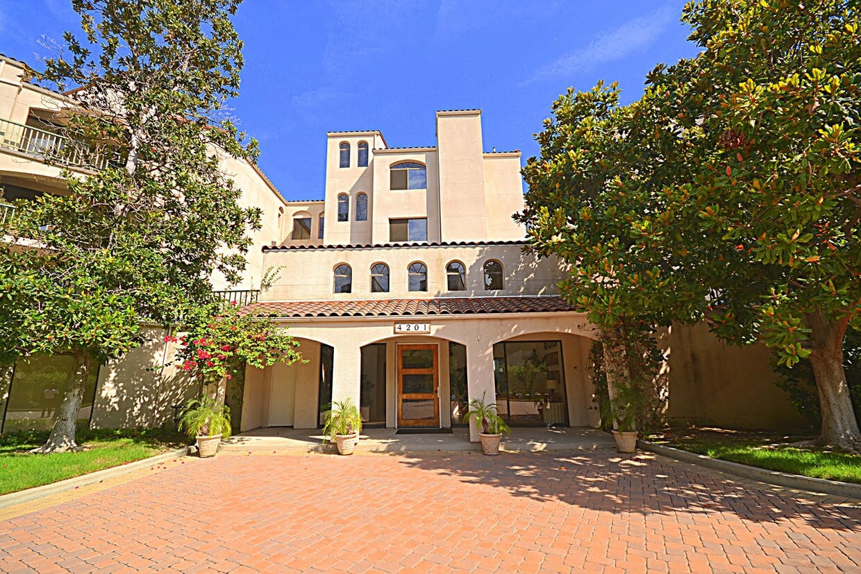
4201 Via Marisol Via
4201 Via Marisol Via,
Los Angeles,
CA
90042
2 Weeks Ago
Favorites
4201 Via Marisol Via

Favorites
Check Back Soon for Upcoming Availability
Fees and Policies
The fees below are based on community-supplied data and may exclude additional fees and utilities.
- Parking
-
Garage--
Details
Utilities Included
-
Water
-
Trash Removal
-
Sewer
Lease Options
-
11 Months
Property Information
-
3 units
About 4201 Via Marisol Via Los Angeles, CA 90042
VACANT- Most sought after resort like complex --Completely remodeled top floor unit, Hardwood floors, granite counters, Central air, all kitchen appliances included, Lots of closets, 2 tandem assigned parking in a gated garage, Most desirable and sought after complex in Monterey Hills. The complex has pool spa, GYM, Sauna and recreation room.. Owner pays for water and trash. 20 feet high ceiling, lots of closets, wood burning fireplace, balcony, 24/7 very quiet, close to all major freeways, shopping, Gold line light rail, DTLA, Old Town Pasadena, Paseo Colorado and USC Medical Center. Small pets only. Ready to move-in.
4201 Via Marisol Via is a condo located in Los Angeles County and the 90042 ZIP Code.
Condo Features
Air Conditioning
Dishwasher
Washer/Dryer Hookup
Refrigerator
- Washer/Dryer Hookup
- Air Conditioning
- Smoke Free
- Fireplace
- Dishwasher
- Kitchen
- Oven
- Refrigerator
- Dining Room
- Recreation Room
- Controlled Access
- Elevator
- Fitness Center
- Sauna
- Spa
- Pool
- Gated
- Balcony
Location
Get Directions
A quiet suburb outside of Los Angeles, Monterey Hills is known for its rolling hills, winding residential streets, and elevated city views. Check out Elephant Hill, a popular place to bike or hike that offers beautiful views of the neighborhood. Herman Park is nestled along Highway 110 in the north end of the neighborhood, offering tennis courts, playgrounds, and a dog park. And for more outdoor recreation, visit the biking paths and hiking trails at Ernest E. Debs Regional Park, bordering Monterey Hills.
Monterey Hills is a more secluded part of Northeast Los Angeles with larger lots, single-family homes, and tree-lined streets. However, if you cross over Highway 110, you’ll find theatres, restaurants, services, and more. Monterey Hills is located just seven miles northeast of Downtown Los Angeles and eight miles east of major attractions such as Griffith Park, the Los Angeles Zoo, the Greek Theatre, and Glendale Galleria.
Learn more about living in Monterey HillsBelow are rent ranges for similar nearby apartments
Amenities
- Washer/Dryer Hookup
- Air Conditioning
- Smoke Free
- Fireplace
- Dishwasher
- Kitchen
- Oven
- Refrigerator
- Dining Room
- Recreation Room
- Controlled Access
- Elevator
- Gated
- Balcony
- Fitness Center
- Sauna
- Spa
- Pool
Expenses
Utilities Included
Water, Trash Removal, Sewer
Included
Education
| Colleges & Universities | Distance | ||
|---|---|---|---|
| Colleges & Universities | Distance | ||
| Drive: | 8 min | 3.7 mi | |
| Drive: | 10 min | 3.9 mi | |
| Drive: | 10 min | 4.0 mi | |
| Drive: | 8 min | 4.3 mi |
4201 Via Marisol Via is within 10 minutes or 4.0 miles from Cal State Los Angeles. It is also near Occidental College and USC, Health Sciences Campus.
Transportation options available in Los Angeles include Highland Park Station, located 1.7 miles from 4201 Via Marisol Via. 4201 Via Marisol Via is near Bob Hope, located 18.2 miles or 26 minutes away, and Los Angeles International, located 21.2 miles or 34 minutes away.
| Transit / Subway | Distance | ||
|---|---|---|---|
| Transit / Subway | Distance | ||
|
|
Drive: | 4 min | 1.7 mi |
|
|
Drive: | 6 min | 2.9 mi |
|
|
Drive: | 7 min | 3.2 mi |
|
|
Drive: | 6 min | 3.3 mi |
|
|
Drive: | 7 min | 3.9 mi |
| Commuter Rail | Distance | ||
|---|---|---|---|
| Commuter Rail | Distance | ||
|
|
Drive: | 12 min | 5.2 mi |
|
|
Drive: | 11 min | 5.3 mi |
|
|
Drive: | 13 min | 7.4 mi |
| Drive: | 14 min | 9.2 mi | |
|
|
Drive: | 20 min | 10.0 mi |
| Airports | Distance | ||
|---|---|---|---|
| Airports | Distance | ||
|
Bob Hope
|
Drive: | 26 min | 18.2 mi |
|
Los Angeles International
|
Drive: | 34 min | 21.2 mi |
Time and distance from 4201 Via Marisol Via.
| Shopping Centers | Distance | ||
|---|---|---|---|
| Shopping Centers | Distance | ||
| Drive: | 3 min | 1.5 mi | |
| Drive: | 5 min | 2.0 mi | |
| Drive: | 5 min | 2.2 mi |
4201 Via Marisol Via has 3 shopping centers within 2.2 miles, which is about a 5-minute drive. The miles and minutes will be for the farthest away property.
| Parks and Recreation | Distance | ||
|---|---|---|---|
| Parks and Recreation | Distance | ||
|
Audubon Center at Debs Park
|
Drive: | 5 min | 2.2 mi |
|
Chavez Ravine Arboretum
|
Drive: | 10 min | 5.9 mi |
|
Elysian Park
|
Drive: | 13 min | 5.9 mi |
|
Elyria Canyon Park
|
Drive: | 12 min | 6.2 mi |
|
Marsh Park
|
Drive: | 13 min | 6.5 mi |
4201 Via Marisol Via has 5 parks within 6.5 miles, including Audubon Center at Debs Park, Elyria Canyon Park, and Elysian Park.
| Hospitals | Distance | ||
|---|---|---|---|
| Hospitals | Distance | ||
| Drive: | 7 min | 3.4 mi | |
| Drive: | 8 min | 3.5 mi | |
| Drive: | 8 min | 4.2 mi |
4201 Via Marisol Via has 3 hospitals within 4.2 miles, the nearest is Keck Hospital of USC which is 3.4 miles away and a 7 minute drive.
| Military Bases | Distance | ||
|---|---|---|---|
| Military Bases | Distance | ||
| Drive: | 31 min | 22.8 mi | |
| Drive: | 42 min | 26.9 mi |
4201 Via Marisol Via is 22.8 miles from Los Angeles Air Force Base, and is convenient to other military bases, including Los Alamitos Army Airfield.
You May Also Like
Similar Rentals Nearby
-
-
1 / 50

-
-
1 / 7

-
-
-
1 / 43

-
-
-


What Are Walk Score®, Transit Score®, and Bike Score® Ratings?
Walk Score® measures the walkability of any address. Transit Score® measures access to public transit. Bike Score® measures the bikeability of any address.
What is a Sound Score Rating?
A Sound Score Rating aggregates noise caused by vehicle traffic, airplane traffic and local sources