

$4,300 / Month
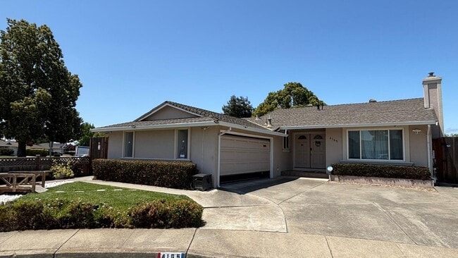
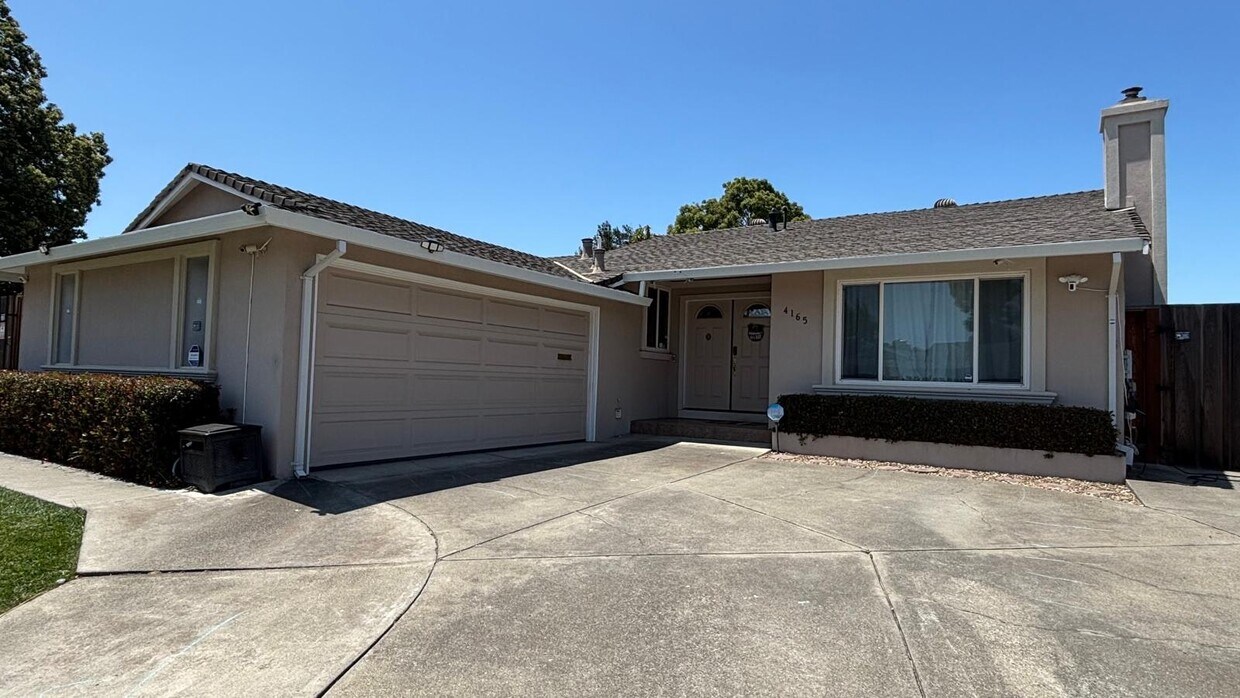
4165 Sabio Ct
Fremont, CA 94536
Today
Favorites
650-517-6960
-
Bedrooms
3
-
Bathrooms
2
-
Square Feet
1,256 sq ft
-
Available
Available Now
4165 Sabio Ct

Favorites
About This Home
12 Month Lease,
$4,300 deposit,
Available Now
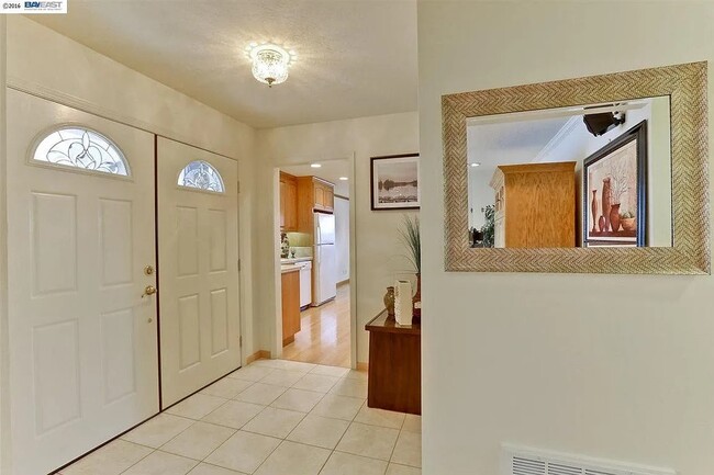
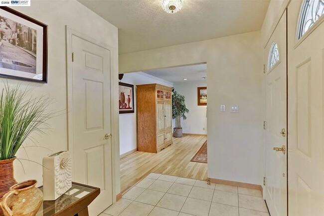
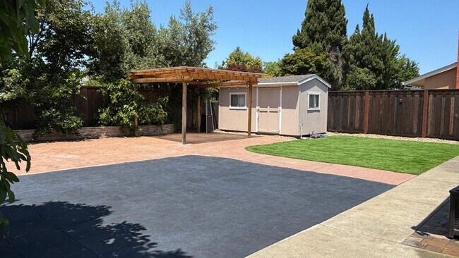
Immaculate & Stunning Home in a Quiet Court Location! Welcome to this beautifully maintained home offering exceptional curb appeal and a gorgeous backyard oasis. Featuring 3 bedrooms and 2 full bathrooms, this residence is ideal for both relaxation and entertaining. The home includes dual-pane windows and doors for year-round comfort and energy efficiency. The kitchen is fully equipped with a gas cooktop, electric single wall oven, dishwasher, and refrigerator. A washer and dryer are also included for your convenience. Additional highlights include central AC and heating, a 240-volt outlet for electric vehicle charging, and a large backyard with automatic sprinklers, multiple fruit trees, and ample storage space. Conveniently located near Highways 880 & 84—ideal for Peninsula and 880 corridor commuters—this home is also zoned for highly regarded schools: Ponderosa Elementary, Thornton Junior High, and American High School. Don’t miss out on this exceptional opportunity—schedule your private tour today!
4165 Sabio Ct is a house located in Alameda County and the 94536 ZIP Code. This area is served by the Fremont Unified attendance zone.
* Price shown is base rent and may not include non-optional fees and utilities.
Price, availability, fees, and any applicable rent special are subject to change without notice.
* Square footage definitions vary. Displayed square footage is approximate.
House Features
Washer/Dryer
Air Conditioning
Dishwasher
Microwave
- Washer/Dryer
- Air Conditioning
- Dishwasher
- Microwave
- Range
- Refrigerator
Fees and Policies
The fees below are based on community-supplied data and may exclude additional fees and utilities.
Details
Lease Options
-
12 Months
Contact
- Listed by PUNIT LAKHANI
- Phone Number
- Contact
Location
Get Directions
Amenities
- Washer/Dryer
- Air Conditioning
- Dishwasher
- Microwave
- Range
- Refrigerator
Sandwiched between Interstate 880 and Fremont Boulevard, the Cabrillo neighborhood gives its residents access to main roads, schools and shopping, while upholding Fremont’s multicultural reputation. Just a block away from the bustling center of the Centerville District, Cabrillo and its residents appreciate quiet East Bay Area living. Locals can drive or take the BART train to San Francisco, less than an hour away, or stick around in Fremont for a night out in Centerville.
In Cabrillo, travelers can live in small and large houses alike while learning about the history and culture of one of the Bay Area’s most hidden gems. Enjoy living in one of the safest cities in the United States while being close to all the urban attractions San Francisco has to offer.
Learn more about living in Cabrillo
Education
| Colleges & Universities | Distance | ||
|---|---|---|---|
| Colleges & Universities | Distance | ||
| Drive: | 10 min | 5.3 mi | |
| Drive: | 17 min | 7.7 mi | |
| Drive: | 15 min | 8.8 mi | |
| Drive: | 16 min | 9.6 mi |
4165 Sabio Ct is within 10 minutes or 5.3 miles from Ohlone College, Newark. It is also near Ohlone College, Fremont Campus and Chabot College.
Schools


Public Elementary School
Grades 1-5
709 Students
Attendance Zone
Public Elementary School
Grades K-5
343 Students
Nearby
Public Middle School
Grades 6-8
1,302 Students
Attendance Zone
Public High School
Grades 9-12
2,501 Students
Attendance Zone
Private Elementary & Middle School
Grades K-8
45 Students
Nearby
Private Elementary, Middle & High School
Grades PK-12
691 Students
Nearby
School data provided by
 The GreatSchools Rating helps parents compare schools within a state based on a variety of school quality indicators and provides a helpful picture of how effectively each school serves all of its students. Ratings are on a scale of 1 (below average) to 10 (above average) and can include test scores, college readiness, academic progress, advanced courses, equity, discipline and attendance data. We also advise parents to visit schools, consider other information on school performance and programs, and consider family needs as part of the school selection process.
View GreatSchools Rating Methodology
Data provided by GreatSchools.org © 2025. All rights reserved.
View GreatSchools Rating Methodology
Data provided by GreatSchools.org © 2025. All rights reserved.
Transportation options available in Fremont include Union City Station, located 2.7 miles from 4165 Sabio Ct. 4165 Sabio Ct is near Metro Oakland International, located 17.5 miles or 25 minutes away, and Norman Y Mineta San Jose International, located 20.2 miles or 27 minutes away.
| Transit / Subway | Distance | ||
|---|---|---|---|
| Transit / Subway | Distance | ||
|
|
Drive: | 7 min | 2.7 mi |
|
|
Drive: | 9 min | 3.7 mi |
|
|
Drive: | 9 min | 3.8 mi |
|
|
Drive: | 13 min | 7.5 mi |
|
|
Drive: | 15 min | 9.0 mi |
| Commuter Rail | Distance | ||
|---|---|---|---|
| Commuter Rail | Distance | ||
| Drive: | 3 min | 1.5 mi | |
| Drive: | 4 min | 1.7 mi | |
| Drive: | 14 min | 9.3 mi | |
|
|
Drive: | 14 min | 9.3 mi |
| Drive: | 28 min | 17.9 mi |
| Airports | Distance | ||
|---|---|---|---|
| Airports | Distance | ||
|
Metro Oakland International
|
Drive: | 25 min | 17.5 mi |
|
Norman Y Mineta San Jose International
|
Drive: | 27 min | 20.2 mi |
Time and distance from 4165 Sabio Ct.
| Shopping Centers | Distance | ||
|---|---|---|---|
| Shopping Centers | Distance | ||
| Walk: | 9 min | 0.5 mi | |
| Walk: | 13 min | 0.7 mi | |
| Walk: | 16 min | 0.9 mi |
4165 Sabio Ct has 3 shopping centers within 0.9 mile, which is about a 16-minute walk. The miles and minutes will be for the farthest away property.
| Parks and Recreation | Distance | ||
|---|---|---|---|
| Parks and Recreation | Distance | ||
|
Quarry Lakes Regional Recreation Area
|
Drive: | 3 min | 1.3 mi |
|
Alameda Creek Regional Trail
|
Drive: | 4 min | 1.5 mi |
|
Ardenwood Historic Farm
|
Drive: | 6 min | 2.6 mi |
|
Niles Canyon Railway
|
Drive: | 9 min | 4.2 mi |
|
Niles Community Park
|
Drive: | 10 min | 4.4 mi |
4165 Sabio Ct has 5 parks within 4.4 miles, including Quarry Lakes Regional Recreation Area, Alameda Creek Regional Trail, and Ardenwood Historic Farm.
| Hospitals | Distance | ||
|---|---|---|---|
| Hospitals | Distance | ||
| Drive: | 8 min | 3.6 mi | |
| Drive: | 8 min | 3.7 mi | |
| Drive: | 11 min | 6.5 mi |
4165 Sabio Ct has 3 hospitals within 6.5 miles, the nearest is Washington Hospital which is 3.6 miles away and a 8 minute drive.
| Military Bases | Distance | ||
|---|---|---|---|
| Military Bases | Distance | ||
| Drive: | 29 min | 18.9 mi |
4165 Sabio Ct is 18.9 miles and a 29 minute drive from Ames Research Center.
You May Also Like
Similar Rentals Nearby


What Are Walk Score®, Transit Score®, and Bike Score® Ratings?
Walk Score® measures the walkability of any address. Transit Score® measures access to public transit. Bike Score® measures the bikeability of any address.
What is a Sound Score Rating?
A Sound Score Rating aggregates noise caused by vehicle traffic, airplane traffic and local sources
4165 Sabio Ct
Fremont, CA 94536