
$4,700 / Month
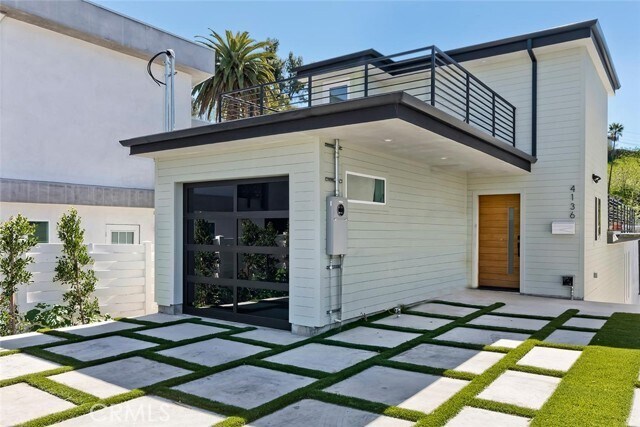
4136 Raynol St
Los Angeles, CA 90032
Today
Favorites
626-584-0101
-
Bedrooms
2
-
Bathrooms
3
-
Square Feet
2,048 sq ft
-
Available
Available Now
Highlights
- Built in 2025 | New Construction
- Primary Bedroom Suite
- All Bedrooms Downstairs
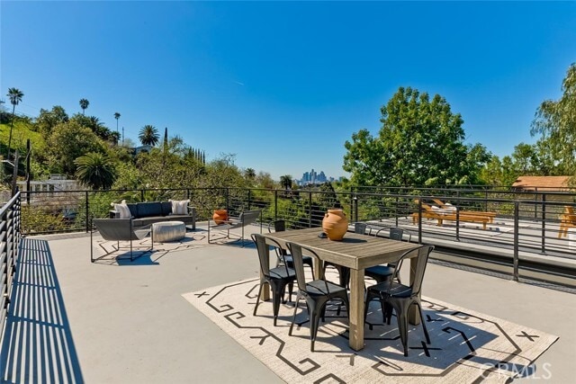
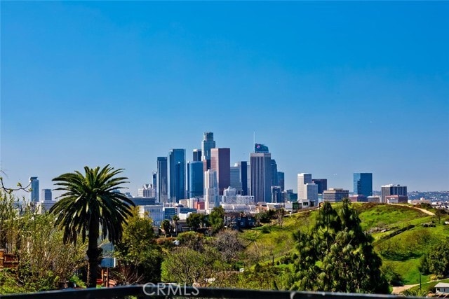
- City Lights View
- Property is near a park
- Hiking Trails
4136 Raynol St

Favorites
About This Home
12 Month Lease,
$4,700 deposit,
Available Now
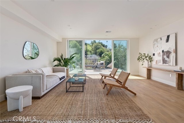
Located in the hillside community of Rose Hill Court just south of Montecito Heights, this stunning new build features two spacious bedrooms, each with its own en suite bathroom (the Primary has a soaker tub and walk in shower), and three rooftop decks with awesome views of downtown Los Angeles, ideal for outdoor entertaining. Ernest Debs Regional Park and Rosehill park, which are nearby offer biking and hiking trails, and the property is located just minutes from Highland Park, South Pasadena, and downtown L.A. This property is an absolute must see. Available July 1. MLS# PF25134870
4136 Raynol St is a house located in Los Angeles County and the 90032 ZIP Code. This area is served by the Los Angeles Unified attendance zone.
* Price shown is base rent and may not include non-optional fees and utilities.
Price, availability, fees, and any applicable rent special are subject to change without notice.
* Square footage definitions vary. Displayed square footage is approximate.
Home Details
Home Type
Single Family Detached Home
Year Built
Built in 2025 | New Construction
Accessible Home Design
Entry on the 3rd floor
Bedrooms and Bathrooms
Primary Bedroom Suite
All Bedrooms Down
2.5 Bathrooms
2 Bedrooms
Home Design
Split Level Home
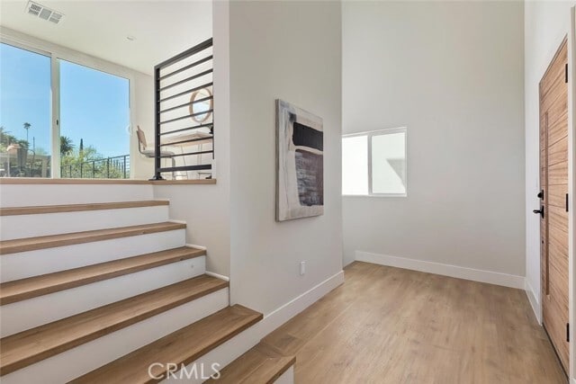
Interior Spaces
Formal Entry
2,048 Sq Ft Home
3-Story Property
Laundry
Laundry Room
Stacked Washer and Dryer
Laundry in Kitchen
Listing and Financial Details
Seller Considering Concessions
Security Deposit $4,700
12-Month Minimum Lease Term
Available 7/1/25
Tax Lot 432
Tax Tract Number 199202
Assessor Parcel Number 5305016002
Rent includes gardener, water
Location
Property is near a park
Urban Location
Lot Details
5,182 Sq Ft Lot
No Common Walls
Property is zoned LAR1
Parking
1 Car Attached Garage
Utilities
Central Air
Views
City Lights
Canyon
Hills
Community Details
Overview
No Home Owners Association
Recreation
Hiking Trails
Park
Bike Trail
Fees and Policies
The fees below are based on community-supplied data and may exclude additional fees and utilities.
- Parking
-
Other--
Details
Utilities Included
-
Water
Lease Options
-
12 Months
Contact
- Listed by Christopher Risucci | Engel & Volkers Pasadena
- Phone Number
- Contact
-
Source
 California Regional Multiple Listing Service
Copyright 2025 © California Regional MLS. All rights reserved.
Location
Get Directions
Amenities
- Washer/Dryer
- Air Conditioning
Expenses
Utilities Included
Water
Included
Situated in northeast Los Angeles, just four miles from downtown, Montecito Heights sits atop a hilly landscape separating LA from the San Gabriel Valley. From the neighborhood’s steep hills, you can catch stunning views of downtown and the San Gabriel Valley in addition to the Arroyo Seco and even the Pacific Ocean (on a clear day).
Montecito Heights is known for its secluded feel despite being minutes away from Downtown LA. Natural beauty and lush parks abound in Montecito Heights. Ernest E. Debs Regional Park is one of the neighborhood’s defining features, touting 300 acres of scenic hiking trails, biking paths, picnic tables, a peaceful pond, and the striking panoramic views the neighborhood is revered for.
Montecito Heights is also home to the Heritage Square Museum, a living history museum that details life in 19th-century Southern California.
Learn more about living in Montecito Heights
Education
| Colleges & Universities | Distance | ||
|---|---|---|---|
| Colleges & Universities | Distance | ||
| Drive: | 6 min | 2.5 mi | |
| Drive: | 10 min | 3.8 mi | |
| Drive: | 13 min | 5.1 mi | |
| Drive: | 13 min | 6.5 mi |
4136 Raynol St is within 6 minutes or 2.5 miles from USC, Health Sciences Campus. It is also near Cal State Los Angeles and Occidental College.
Schools


Public Elementary & Middle School
Grades K-8
125 Students
Attendance Zone
Charter Elementary School
Grades K-5
75 Students
Nearby
Public High School
Grades 9-12
1,028 Students
Attendance Zone
Public High School
Grades 9-12
1,406 Students
Attendance Zone
Private Elementary & Middle School
Grades K-8
125 Students
Nearby
Private Elementary School
Grades PK-5
131 Students
Nearby
Private High School
Grades 9-12
279 Students
Nearby
School data provided by
 The GreatSchools Rating helps parents compare schools within a state based on a variety of school quality indicators and provides a helpful picture of how effectively each school serves all of its students. Ratings are on a scale of 1 (below average) to 10 (above average) and can include test scores, college readiness, academic progress, advanced courses, equity, discipline and attendance data. We also advise parents to visit schools, consider other information on school performance and programs, and consider family needs as part of the school selection process.
View GreatSchools Rating Methodology
Data provided by GreatSchools.org © 2025. All rights reserved.
View GreatSchools Rating Methodology
Data provided by GreatSchools.org © 2025. All rights reserved.
Transportation options available in Los Angeles include Southwest Museum Station, located 2.4 miles from 4136 Raynol St. 4136 Raynol St is near Bob Hope, located 17.2 miles or 26 minutes away, and Los Angeles International, located 20.2 miles or 34 minutes away.
| Transit / Subway | Distance | ||
|---|---|---|---|
| Transit / Subway | Distance | ||
|
|
Drive: | 8 min | 2.4 mi |
|
|
Drive: | 7 min | 2.6 mi |
|
|
Drive: | 8 min | 2.8 mi |
|
|
Drive: | 8 min | 2.9 mi |
|
|
Drive: | 8 min | 3.7 mi |
| Commuter Rail | Distance | ||
|---|---|---|---|
| Commuter Rail | Distance | ||
|
|
Drive: | 10 min | 4.0 mi |
|
|
Drive: | 9 min | 4.1 mi |
|
|
Drive: | 13 min | 6.5 mi |
| Drive: | 12 min | 8.1 mi | |
|
|
Drive: | 19 min | 11.5 mi |
| Airports | Distance | ||
|---|---|---|---|
| Airports | Distance | ||
|
Bob Hope
|
Drive: | 26 min | 17.2 mi |
|
Los Angeles International
|
Drive: | 34 min | 20.2 mi |
Time and distance from 4136 Raynol St.
| Shopping Centers | Distance | ||
|---|---|---|---|
| Shopping Centers | Distance | ||
| Drive: | 4 min | 1.5 mi | |
| Drive: | 6 min | 2.2 mi | |
| Drive: | 7 min | 2.6 mi |
4136 Raynol St has 3 shopping centers within 2.6 miles, which is about a 7-minute drive. The miles and minutes will be for the farthest away property.
| Parks and Recreation | Distance | ||
|---|---|---|---|
| Parks and Recreation | Distance | ||
|
Audubon Center at Debs Park
|
Drive: | 6 min | 1.7 mi |
|
Hollenbeck Lake
|
Drive: | 8 min | 3.9 mi |
|
Chavez Ravine Arboretum
|
Drive: | 10 min | 4.6 mi |
|
Elysian Park
|
Drive: | 13 min | 4.6 mi |
|
Elyria Canyon Park
|
Drive: | 12 min | 5.2 mi |
4136 Raynol St has 5 parks within 5.2 miles, including Audubon Center at Debs Park, Elyria Canyon Park, and Elysian Park.
| Hospitals | Distance | ||
|---|---|---|---|
| Hospitals | Distance | ||
| Drive: | 5 min | 2.2 mi | |
| Drive: | 7 min | 3.1 mi | |
| Drive: | 8 min | 3.5 mi |
4136 Raynol St has 3 hospitals within 3.5 miles, the nearest is Keck Hospital of USC which is 2.2 miles away and a 5 minute drive.
| Military Bases | Distance | ||
|---|---|---|---|
| Military Bases | Distance | ||
| Drive: | 32 min | 21.8 mi | |
| Drive: | 40 min | 27.3 mi |
4136 Raynol St is 21.8 miles from Los Angeles Air Force Base, and is convenient to other military bases, including Los Alamitos Army Airfield.
You May Also Like
Similar Rentals Nearby


What Are Walk Score®, Transit Score®, and Bike Score® Ratings?
Walk Score® measures the walkability of any address. Transit Score® measures access to public transit. Bike Score® measures the bikeability of any address.
What is a Sound Score Rating?
A Sound Score Rating aggregates noise caused by vehicle traffic, airplane traffic and local sources

4136 Raynol St
Los Angeles, CA 90032