
Clarence & Harrison Apartments
620-622 Harrison St,
Oak Park, IL 60304
$1,200 - $1,750
Studio - 2 Beds

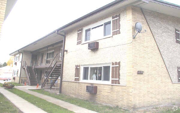

Experience Berwyn living at 4133 S Harlem Ave. This community can be found on S. Harlem Ave in the 60402 area of Berwyn. Come by to view the available floorplans. The professional leasing staff is waiting to show you all that this community has in store. Contact us or drop by the leasing office to talk about leasing your new apartment and find your new place at 4133 S Harlem Ave.
4133 S Harlem Ave is an apartment community located in Cook County and the 60402 ZIP Code. This area is served by the Lyons School District 103 attendance zone.
Situated just 10 miles west of Downtown Chicago, Berwyn provides easy access to modern conveniences and ample green space. Expansive parks are located just west of this suburban city, including Miller Meadow, McCormick Woods, and Brookfield Woods, which is in walking distance of the Brookfield Zoo.
Nestled in Cook County, Berwyn is a suburban community close to shops and restaurants at North Riverside Park Mall. Long-standing homes with spacious back alleys and low-lying apartment rentals are accentuated by towering trees and spacious sidewalks. Residents enjoy the convenience of three local Metra rail stations, a wide array of local eateries, and direct access to Interstate 290 from their Berwyn apartments.
Chicago attractions and beaches are just 11 miles east. Each year the city holds the Houby Day Parade honoring Czechoslovakian heritage and the fall harvest, as well as a vintage car show and Cartopia near Berwyn’s Historic Route 66 access.
Learn more about living in Berwyn| Colleges & Universities | Distance | ||
|---|---|---|---|
| Colleges & Universities | Distance | ||
| Drive: | 12 min | 6.1 mi | |
| Drive: | 13 min | 6.1 mi | |
| Drive: | 14 min | 6.6 mi | |
| Drive: | 15 min | 8.5 mi |


Transportation options available in Berwyn include 54Th/Cermak Station, located 4.4 miles from 4133 S Harlem Ave. 4133 S Harlem Ave is near Chicago Midway International, located 4.3 miles or 7 minutes away, and Chicago O'Hare International, located 16.1 miles or 31 minutes away.
| Transit / Subway | Distance | ||
|---|---|---|---|
| Transit / Subway | Distance | ||
|
|
Drive: | 8 min | 4.4 mi |
|
|
Drive: | 8 min | 4.5 mi |
|
|
Drive: | 8 min | 4.6 mi |
|
|
Drive: | 10 min | 5.6 mi |
|
|
Drive: | 12 min | 6.6 mi |
| Commuter Rail | Distance | ||
|---|---|---|---|
| Commuter Rail | Distance | ||
|
|
Walk: | 21 min | 1.1 mi |
|
|
Drive: | 3 min | 1.5 mi |
|
|
Drive: | 4 min | 1.7 mi |
|
|
Drive: | 4 min | 2.0 mi |
|
|
Drive: | 4 min | 2.0 mi |
| Airports | Distance | ||
|---|---|---|---|
| Airports | Distance | ||
|
Chicago Midway International
|
Drive: | 7 min | 4.3 mi |
|
Chicago O'Hare International
|
Drive: | 31 min | 16.1 mi |
Scores provided by
Traffic
BusyAirport
ActiveBusinesses
CalmScores provided by
HowLoud What is a Sound Score Rating? A Sound Score Rating aggregates noise caused by vehicle traffic, airplane traffic and local sources. How It WorksTime and distance from 4133 S Harlem Ave.
| Shopping Centers | Distance | ||
|---|---|---|---|
| Shopping Centers | Distance | ||
| Walk: | 6 min | 0.3 mi | |
| Walk: | 9 min | 0.5 mi | |
| Walk: | 18 min | 1.0 mi |
| Parks and Recreation | Distance | ||
|---|---|---|---|
| Parks and Recreation | Distance | ||
|
White Eagle Woods-North
|
Walk: | 8 min | 0.4 mi |
|
White Eagle Woods-South
|
Walk: | 10 min | 0.5 mi |
|
Andrew Toman Grove
|
Drive: | 6 min | 2.6 mi |
|
Brookfield Zoo
|
Drive: | 7 min | 2.9 mi |
|
Schuth's Grove / Callahan Grove
|
Drive: | 6 min | 3.5 mi |
| Hospitals | Distance | ||
|---|---|---|---|
| Hospitals | Distance | ||
| Drive: | 3 min | 1.4 mi | |
| Drive: | 8 min | 4.4 mi | |
| Drive: | 9 min | 4.6 mi |
| Military Bases | Distance | ||
|---|---|---|---|
| Military Bases | Distance | ||
| Drive: | 35 min | 22.1 mi |
What Are Walk Score®, Transit Score®, and Bike Score® Ratings?
Walk Score® measures the walkability of any address. Transit Score® measures access to public transit. Bike Score® measures the bikeability of any address.
What is a Sound Score Rating?
A Sound Score Rating aggregates noise caused by vehicle traffic, airplane traffic and local sources.
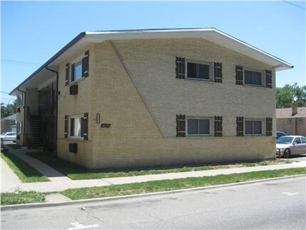
4133 S Harlem Ave
Berwyn, IL 60402


