


$2,890 / Month
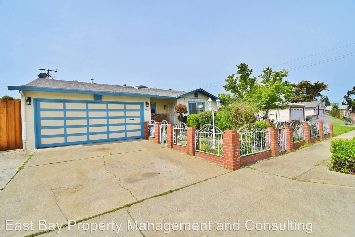
40461 Robin St
Fremont, CA 94538
2 Weeks Ago
Favorites
40461 Robin St

Favorites
Check Back Soon for Upcoming Availability
| Beds | Baths | Average SF |
|---|---|---|
| 3 Bedrooms 3 Bedrooms 3 Br | 2 Baths 2 Baths 2 Ba | — |
About This Property
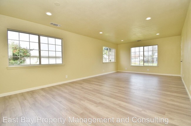
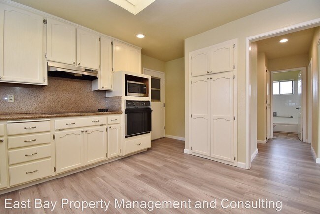
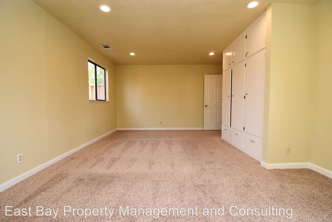
(510) 996-3238 - $2,890 / 3 BR - NICELY REMODELED FREMONT HOME IN SUNDALE - Nicely remodeled home nestled in South Sundale. Flows beautifully with large living room, laminate floors, recessed lighting, gourmet kitchen and washer/dryer. Large back yard with mature trees and storage shed. Gardening included. Small pet negotiable A short walk to very good schools. COMMUTER'S PARADISE...MINUTES TO BART, 880, 237 AND BRIDGE KEY FEATURES: Address is 40461 Robin Street 1291 square feet Built in 1959 Lot - 6,241 s.f. 3 bedrooms 2 bathrooms 2 car garage Washer/dryer Gardening included Small pet negotiable Lease duration - 1 year Available April 21st Deposit - $2,890 MUST HAVE: Fico score of 680 or above Minimum monthly income of $8,670 Excellent rental history Credit and back round check for each adult over 18 $30 application fee per adult No Section 8 or smokers please CALL MIKE AT EAST BAY PROPERTY MANAGEMENT (RLNE4828838)
40461 Robin St is a house located in Alameda County and the 94538 ZIP Code. This area is served by the Fremont Unified attendance zone.
Location
Get Directions
South Sundale is a small suburban neighborhood about two miles south of Downtown Fremont. This neighborhood is great for renters looking for a quiet, safe community that is still near plenty of amenities. South Sundale is convenient to some of the city’s largest and most popular commercial hubs. NewPark Mall is less than 15 minutes away, and Fremont Boulevard and Washington Boulevard nearby are filled with authentic global eateries, popular retailers, and more. You’ll find residents frequenting neighborhood parks like Blacow Park, which is great for dog walking, jogging, and riding bikes. Locals also enjoy proximity to Freemont’s largest green space, Central Park. This sprawling natural area has something for everyone to enjoy, boasting a skate park, water park, dog park, a golf course, a lake, and so much more. Complemented by palm-tree-lined streets, South Sundale features moderately priced to upscale, ranch-style single-homes, sleek townhomes, and modern apartments.
Learn more about living in South SundaleBelow are rent ranges for similar nearby apartments
Education
| Colleges & Universities | Distance | ||
|---|---|---|---|
| Colleges & Universities | Distance | ||
| Drive: | 6 min | 2.7 mi | |
| Drive: | 10 min | 4.3 mi | |
| Drive: | 17 min | 11.5 mi | |
| Drive: | 20 min | 14.4 mi |
40461 Robin St is within 6 minutes or 2.7 miles from Ohlone College, Newark. It is also near Ohlone College, Fremont Campus and Palmer College of Chiropractic West Campus.
Schools


Public Elementary School
Grades K-5
343 Students
Nearby
Public Elementary School
Grades 1-5
630 Students
Attendance Zone
Public Middle School
Grades 6-8
1,071 Students
Attendance Zone
Public High School
Grades 9-12
1,347 Students
Attendance Zone
Private Elementary & Middle School
Grades PK-8
194 Students
Nearby
Private Elementary & Middle School
Grades K-8
190 Students
Nearby
Private Elementary, Middle & High School
Grades 5-12
Nearby
Private Middle & High School
Grades 7-12
27 Students
Nearby
School data provided by
 The GreatSchools Rating helps parents compare schools within a state based on a variety of school quality indicators and provides a helpful picture of how effectively each school serves all of its students. Ratings are on a scale of 1 (below average) to 10 (above average) and can include test scores, college readiness, academic progress, advanced courses, equity, discipline and attendance data. We also advise parents to visit schools, consider other information on school performance and programs, and consider family needs as part of the school selection process.
View GreatSchools Rating Methodology
Data provided by GreatSchools.org © 2025. All rights reserved.
View GreatSchools Rating Methodology
Data provided by GreatSchools.org © 2025. All rights reserved.
Transportation options available in Fremont include Fremont Station, located 2.6 miles from 40461 Robin St. 40461 Robin St is near Norman Y Mineta San Jose International, located 15.5 miles or 21 minutes away, and Metro Oakland International, located 22.3 miles or 29 minutes away.
| Transit / Subway | Distance | ||
|---|---|---|---|
| Transit / Subway | Distance | ||
|
|
Drive: | 6 min | 2.6 mi |
|
|
Drive: | 7 min | 2.7 mi |
|
|
Drive: | 7 min | 3.5 mi |
|
|
Drive: | 14 min | 7.8 mi |
| Drive: | 17 min | 11.4 mi |
| Commuter Rail | Distance | ||
|---|---|---|---|
| Commuter Rail | Distance | ||
| Drive: | 7 min | 3.5 mi | |
| Drive: | 8 min | 3.5 mi | |
| Drive: | 18 min | 13.1 mi | |
| Drive: | 20 min | 14.5 mi | |
| Drive: | 21 min | 14.5 mi |
| Airports | Distance | ||
|---|---|---|---|
| Airports | Distance | ||
|
Norman Y Mineta San Jose International
|
Drive: | 21 min | 15.5 mi |
|
Metro Oakland International
|
Drive: | 29 min | 22.3 mi |
Time and distance from 40461 Robin St.
| Shopping Centers | Distance | ||
|---|---|---|---|
| Shopping Centers | Distance | ||
| Walk: | 11 min | 0.6 mi | |
| Walk: | 13 min | 0.7 mi | |
| Walk: | 15 min | 0.8 mi |
40461 Robin St has 3 shopping centers within 0.8 mile, which is about a 15-minute walk. The miles and minutes will be for the farthest away property.
| Parks and Recreation | Distance | ||
|---|---|---|---|
| Parks and Recreation | Distance | ||
|
Central Park (Lake Elizabeth)
|
Drive: | 6 min | 2.6 mi |
|
Quarry Lakes Regional Recreation Area
|
Drive: | 10 min | 4.9 mi |
|
Niles Canyon Railway
|
Drive: | 10 min | 5.0 mi |
|
Alameda Creek Regional Trail
|
Drive: | 10 min | 5.1 mi |
|
Niles Community Park
|
Drive: | 12 min | 5.5 mi |
40461 Robin St has 5 parks within 5.5 miles, including Central Park (Lake Elizabeth), Quarry Lakes Regional Recreation Area, and Niles Canyon Railway.
| Hospitals | Distance | ||
|---|---|---|---|
| Hospitals | Distance | ||
| Drive: | 4 min | 2.0 mi | |
| Drive: | 6 min | 2.8 mi | |
| Drive: | 16 min | 11.3 mi |
40461 Robin St has 3 hospitals within 11.3 miles, the nearest is Kaiser Foundation Hospital - Fremont which is 2.0 miles away and a 4 minute drive.
| Military Bases | Distance | ||
|---|---|---|---|
| Military Bases | Distance | ||
| Drive: | 26 min | 18.3 mi |
40461 Robin St is 18.3 miles and a 26 minute drive from Ames Research Center.
You May Also Like
Similar Rentals Nearby


What Are Walk Score®, Transit Score®, and Bike Score® Ratings?
Walk Score® measures the walkability of any address. Transit Score® measures access to public transit. Bike Score® measures the bikeability of any address.
What is a Sound Score Rating?
A Sound Score Rating aggregates noise caused by vehicle traffic, airplane traffic and local sources
40461 Robin St
Fremont, CA 94538