
$3,950 / Month
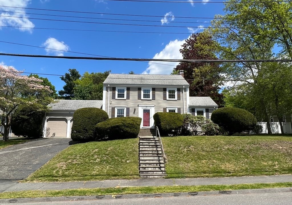
40 Westgate
Wellesley, MA 02481
2 Weeks Ago
Favorites
40 Westgate

Favorites
Check Back Soon for Upcoming Availability
| Beds | Baths | Average SF |
|---|---|---|
| 3 Bedrooms 3 Bedrooms 3 Br | 1.5 Baths 1.5 Baths 1.5 Ba | 1,610 SF |
About This Property
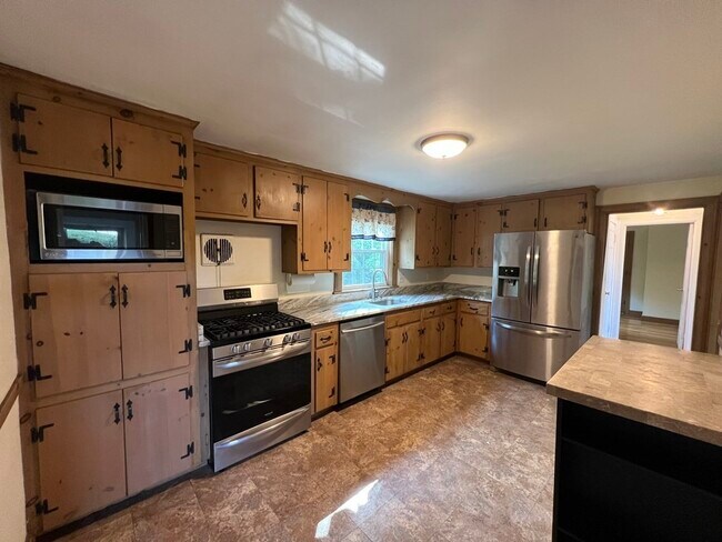
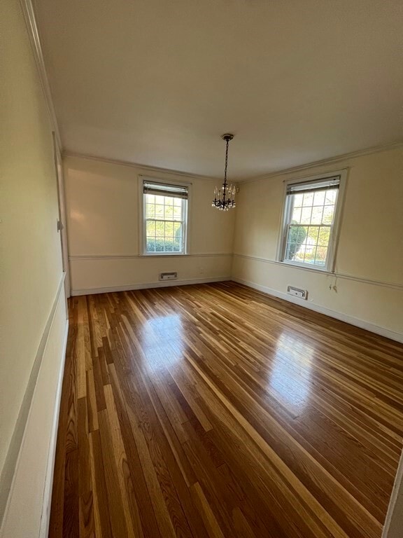
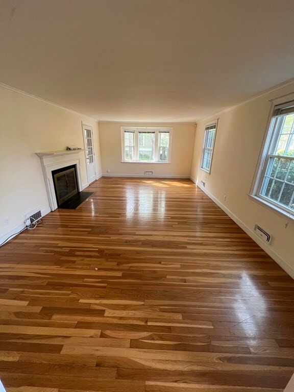
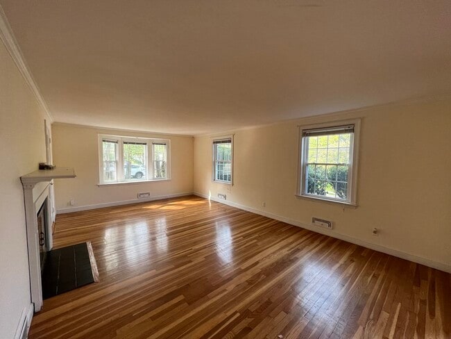
Here it is! The one you've been looking for. The perfect place to call home. From the wonderful neighborhood to the highly sought after school systems,this property will not disappoint! What else does this home have to offer you ask? Well,the list is endless... You will be delighted with the updated kitchen,hardwood floors,screened in porch,spacious backyard,two car attached garage,abundance of storage space,walkability to playgrounds/parks and much,much more! Your commute to Boston will be a breeze with easy access to Rt. 9 and the commuter rail,just minutes down the road. Anything else you ask? Yes! Wellesley offers its residents an impressive array of shopping and dining options as well as activities galore! What are you waiting for? This one is a must see!
40 Westgate is a house located in Norfolk County and the 02481 ZIP Code. This area is served by the Wellesley attendance zone.
Location
Get Directions
Just west of Boston and East of Worcester sits Metro West, a region that houses a group of towns and cities with significant historical backgrounds. A total of 19 municipalities make up the core of this community, but other municipalities are considered to be a part of the Interstate 495/Metro West Corridor.
Learn more about living in Metro WestBelow are rent ranges for similar nearby apartments
| Beds | Average Size | Lowest | Typical | Premium |
|---|---|---|---|---|
| Studio Studio Studio | 515-518 Sq Ft | $1,400 | $2,511 | $8,898 |
| 1 Bed 1 Bed 1 Bed | 873-875 Sq Ft | $1,495 | $3,001 | $9,275 |
| 2 Beds 2 Beds 2 Beds | 1273-1275 Sq Ft | $1,900 | $3,682 | $12,413 |
| 3 Beds 3 Beds 3 Beds | 1580-1585 Sq Ft | $2,500 | $4,846 | $18,973 |
| 4 Beds 4 Beds 4 Beds | 3649 Sq Ft | $1,125 | $6,733 | $17,000 |
Education
| Colleges & Universities | Distance | ||
|---|---|---|---|
| Colleges & Universities | Distance | ||
| Drive: | 8 min | 3.1 mi | |
| Drive: | 9 min | 4.0 mi | |
| Drive: | 15 min | 5.6 mi | |
| Drive: | 20 min | 9.8 mi |
40 Westgate is within 8 minutes or 3.1 miles from Wellesley College. It is also near Babson College and Brandeis University.
Schools


Public Elementary School
Grades K-5
280 Students
Nearby
Public Elementary School
Grades K-5
271 Students
Attendance Zone
Public Middle School
Grades 6-8
922 Students
Attendance Zone
Public High School
Grades 9-12
1,412 Students
Attendance Zone
Private Elementary & Middle School
Grades PK-8
185 Students
Nearby
Private Middle & High School
Grades 6-12
496 Students
Nearby
School data provided by
 The GreatSchools Rating helps parents compare schools within a state based on a variety of school quality indicators and provides a helpful picture of how effectively each school serves all of its students. Ratings are on a scale of 1 (below average) to 10 (above average) and can include test scores, college readiness, academic progress, advanced courses, equity, discipline and attendance data. We also advise parents to visit schools, consider other information on school performance and programs, and consider family needs as part of the school selection process.
View GreatSchools Rating Methodology
Data provided by GreatSchools.org © 2025. All rights reserved.
View GreatSchools Rating Methodology
Data provided by GreatSchools.org © 2025. All rights reserved.
Transportation options available in Wellesley include Woodland Station, located 5.6 miles from 40 Westgate. 40 Westgate is near General Edward Lawrence Logan International, located 19.5 miles or 32 minutes away, and Worcester Regional, located 31.8 miles or 53 minutes away.
| Transit / Subway | Distance | ||
|---|---|---|---|
| Transit / Subway | Distance | ||
|
|
Drive: | 10 min | 5.6 mi |
|
|
Drive: | 12 min | 5.7 mi |
|
|
Drive: | 12 min | 6.2 mi |
|
|
Drive: | 13 min | 6.8 mi |
|
|
Drive: | 13 min | 7.0 mi |
| Commuter Rail | Distance | ||
|---|---|---|---|
| Commuter Rail | Distance | ||
|
|
Drive: | 6 min | 2.1 mi |
|
|
Drive: | 5 min | 2.4 mi |
|
|
Drive: | 8 min | 2.7 mi |
|
|
Drive: | 9 min | 5.1 mi |
|
|
Drive: | 21 min | 12.5 mi |
| Airports | Distance | ||
|---|---|---|---|
| Airports | Distance | ||
|
General Edward Lawrence Logan International
|
Drive: | 32 min | 19.5 mi |
|
Worcester Regional
|
Drive: | 53 min | 31.8 mi |
Time and distance from 40 Westgate.
| Shopping Centers | Distance | ||
|---|---|---|---|
| Shopping Centers | Distance | ||
| Drive: | 4 min | 2.2 mi | |
| Drive: | 6 min | 2.5 mi | |
| Drive: | 6 min | 2.8 mi |
40 Westgate has 3 shopping centers within 2.8 miles, which is about a 6-minute drive. The miles and minutes will be for the farthest away property.
| Parks and Recreation | Distance | ||
|---|---|---|---|
| Parks and Recreation | Distance | ||
|
Whitin Observatory
|
Drive: | 6 min | 2.2 mi |
|
Wellesley College Botanic Gardens
|
Drive: | 5 min | 2.5 mi |
|
Elm Bank Reservation
|
Drive: | 11 min | 4.4 mi |
|
Horticultural Society at Elm Bank
|
Drive: | 12 min | 4.5 mi |
|
Hamlen Woods
|
Drive: | 9 min | 4.7 mi |
40 Westgate has 5 parks within 4.7 miles, including Whitin Observatory, Wellesley College Botanic Gardens, and Hamlen Woods.
| Hospitals | Distance | ||
|---|---|---|---|
| Hospitals | Distance | ||
| Drive: | 10 min | 5.3 mi | |
| Drive: | 11 min | 5.9 mi | |
| Drive: | 14 min | 6.1 mi |
40 Westgate has 3 hospitals within 6.1 miles, the nearest is Newton - Wellesley Hospital which is 5.3 miles away and a 10 minute drive.
| Military Bases | Distance | ||
|---|---|---|---|
| Military Bases | Distance | ||
| Drive: | 8 min | 4.7 mi | |
| Drive: | 27 min | 13.6 mi |
40 Westgate is 4.7 miles from US Military Reservation, and is convenient to other military bases, including Hanscom Air Force Base.
You May Also Like
Similar Rentals Nearby


What Are Walk Score®, Transit Score®, and Bike Score® Ratings?
Walk Score® measures the walkability of any address. Transit Score® measures access to public transit. Bike Score® measures the bikeability of any address.
What is a Sound Score Rating?
A Sound Score Rating aggregates noise caused by vehicle traffic, airplane traffic and local sources

40 Westgate
Wellesley, MA 02481