

$2,400 / Month
3961 Via Marisol Via Unit 221 - 0
Los Angeles, CA 90042
2 Weeks Ago
Favorites
3961 Via Marisol Via Unit 221 - 0

Favorites
Check Back Soon for Upcoming Availability
| Beds | Baths | Average SF |
|---|---|---|
| 2 Bedrooms 2 Bedrooms 2 Br | 2 Baths 2 Baths 2 Ba | — |
About This Property
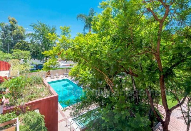
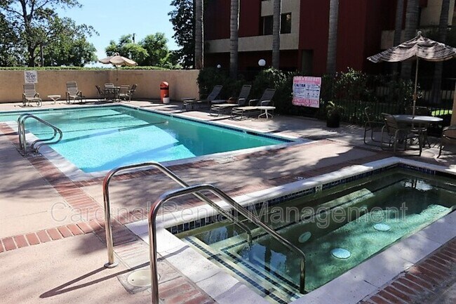
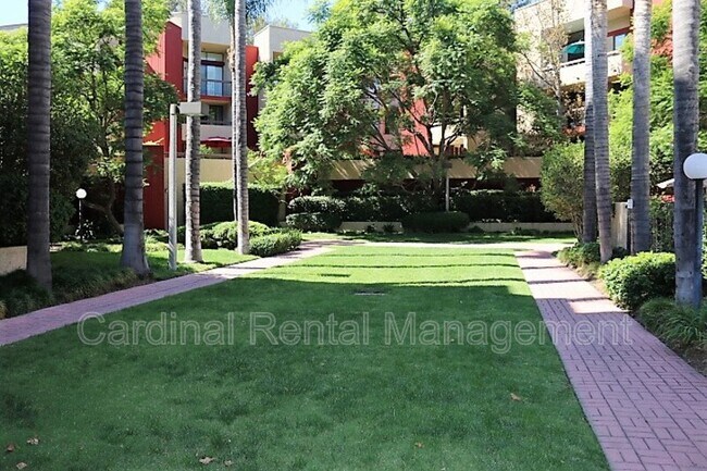
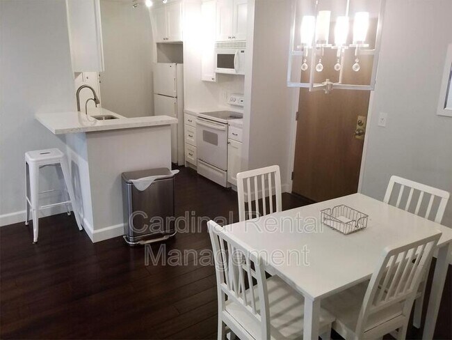
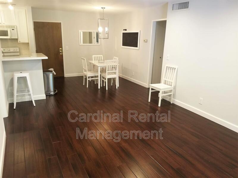
This open floor plan 2 bedroom 2 bath condo is located in the quiet Monterrey hills and features a private balcony overlooking the beautifully landscaped courtyard. Centrally located between downtown Los Angeles and Pasadena it makes for a convenient drive to work and entertainment. There are in unit washer and dryer and the complex has a pool, exercise room, rec room and two underground parking spaces. No Pets Landlord pays for trash and water Required for application approval: Credit and background check, income verification. Security Deposit 2400 BRE#02020920
3961 Via Marisol Via is a condo located in Los Angeles County and the 90042 ZIP Code. This area is served by the Los Angeles Unified attendance zone.

3961 Via Marisol
90 Units
3 Stories
Built in 1982
113,592 Sq Ft
3961 Via Marisol, known as Muir Terrace, is a 3-story condominium complex nestled in the tranquil Monterey Heights neighborhood of Los Angeles. Completed in 1982, this 90-unit development offers a peaceful retreat from the bustling city while maintaining proximity to urban amenities. The building's design incorporates elements that maximize the natural surroundings, with many units featuring panoramic views of the lush hillsides and city lights. Situated in an area known for attracting creatives and outdoor enthusiasts, Muir Terrace provides a blend of suburban serenity and urban accessibility.
Learn more about 3961 Via Marisol
Location
Get Directions
A quiet suburb outside of Los Angeles, Monterey Hills is known for its rolling hills, winding residential streets, and elevated city views. Check out Elephant Hill, a popular place to bike or hike that offers beautiful views of the neighborhood. Herman Park is nestled along Highway 110 in the north end of the neighborhood, offering tennis courts, playgrounds, and a dog park. And for more outdoor recreation, visit the biking paths and hiking trails at Ernest E. Debs Regional Park, bordering Monterey Hills.
Monterey Hills is a more secluded part of Northeast Los Angeles with larger lots, single-family homes, and tree-lined streets. However, if you cross over Highway 110, you’ll find theatres, restaurants, services, and more. Monterey Hills is located just seven miles northeast of Downtown Los Angeles and eight miles east of major attractions such as Griffith Park, the Los Angeles Zoo, the Greek Theatre, and Glendale Galleria.
Learn more about living in Monterey HillsBelow are rent ranges for similar nearby apartments
Education
| Colleges & Universities | Distance | ||
|---|---|---|---|
| Colleges & Universities | Distance | ||
| Drive: | 7 min | 3.4 mi | |
| Drive: | 10 min | 3.8 mi | |
| Drive: | 10 min | 4.1 mi | |
| Drive: | 8 min | 4.5 mi |
3961 Via Marisol Via Unit 221 - 0 is within 10 minutes or 3.8 miles from Cal State Los Angeles. It is also near USC, Health Sciences Campus and Occidental College.
Schools


Charter Elementary School
Grades K-5
75 Students
Nearby
Public Elementary School
Grades K-5
181 Students
Attendance Zone
Public Middle School
Grades 6-8
904 Students
Attendance Zone
Public High School
Grades 9-12
1,028 Students
Attendance Zone
Public High School
Grades 9-12
1,406 Students
Attendance Zone
Private Elementary School
Grades PK-5
131 Students
Nearby
Private Elementary, Middle & High School
Grades K-12
Nearby
Private Elementary & Middle School
Grades K-8
Nearby
School data provided by
 The GreatSchools Rating helps parents compare schools within a state based on a variety of school quality indicators and provides a helpful picture of how effectively each school serves all of its students. Ratings are on a scale of 1 (below average) to 10 (above average) and can include test scores, college readiness, academic progress, advanced courses, equity, discipline and attendance data. We also advise parents to visit schools, consider other information on school performance and programs, and consider family needs as part of the school selection process.
View GreatSchools Rating Methodology
Data provided by GreatSchools.org © 2025. All rights reserved.
View GreatSchools Rating Methodology
Data provided by GreatSchools.org © 2025. All rights reserved.
Transportation options available in Los Angeles include Highland Park Station, located 2.0 miles from 3961 Via Marisol Via Unit 221 - 0. 3961 Via Marisol Via Unit 221 - 0 is near Bob Hope, located 18.5 miles or 27 minutes away, and Los Angeles International, located 21.5 miles or 35 minutes away.
| Transit / Subway | Distance | ||
|---|---|---|---|
| Transit / Subway | Distance | ||
|
|
Drive: | 5 min | 2.0 mi |
|
|
Drive: | 7 min | 3.2 mi |
|
|
Drive: | 8 min | 3.5 mi |
|
|
Drive: | 7 min | 3.5 mi |
|
|
Drive: | 8 min | 4.2 mi |
| Commuter Rail | Distance | ||
|---|---|---|---|
| Commuter Rail | Distance | ||
|
|
Drive: | 11 min | 4.9 mi |
|
|
Drive: | 10 min | 5.0 mi |
|
|
Drive: | 13 min | 7.7 mi |
| Drive: | 13 min | 8.9 mi | |
|
|
Drive: | 20 min | 9.8 mi |
| Airports | Distance | ||
|---|---|---|---|
| Airports | Distance | ||
|
Bob Hope
|
Drive: | 27 min | 18.5 mi |
|
Los Angeles International
|
Drive: | 35 min | 21.5 mi |
Time and distance from 3961 Via Marisol Via Unit 221 - 0.
| Shopping Centers | Distance | ||
|---|---|---|---|
| Shopping Centers | Distance | ||
| Drive: | 4 min | 1.8 mi | |
| Drive: | 6 min | 2.3 mi | |
| Drive: | 6 min | 2.5 mi |
3961 Via Marisol Via Unit 221 - 0 has 3 shopping centers within 2.5 miles, which is about a 6-minute drive. The miles and minutes will be for the farthest away property.
| Parks and Recreation | Distance | ||
|---|---|---|---|
| Parks and Recreation | Distance | ||
|
Audubon Center at Debs Park
|
Drive: | 6 min | 2.5 mi |
|
Chavez Ravine Arboretum
|
Drive: | 11 min | 6.2 mi |
|
Elysian Park
|
Drive: | 14 min | 6.2 mi |
|
Elyria Canyon Park
|
Drive: | 12 min | 6.5 mi |
|
Marsh Park
|
Drive: | 13 min | 6.8 mi |
3961 Via Marisol Via Unit 221 - 0 has 5 parks within 6.8 miles, including Audubon Center at Debs Park, Elyria Canyon Park, and Elysian Park.
| Hospitals | Distance | ||
|---|---|---|---|
| Hospitals | Distance | ||
| Drive: | 6 min | 3.1 mi | |
| Drive: | 8 min | 3.2 mi | |
| Drive: | 8 min | 3.9 mi |
3961 Via Marisol Via Unit 221 - 0 has 3 hospitals within 3.9 miles, the nearest is Keck Hospital of USC which is 3.1 miles away and a 6 minute drive.
| Military Bases | Distance | ||
|---|---|---|---|
| Military Bases | Distance | ||
| Drive: | 32 min | 23.1 mi | |
| Drive: | 41 min | 26.6 mi |
3961 Via Marisol Via Unit 221 - 0 is 23.1 miles from Los Angeles Air Force Base, and is convenient to other military bases, including Los Alamitos Army Airfield.
You May Also Like
Similar Rentals Nearby


What Are Walk Score®, Transit Score®, and Bike Score® Ratings?
Walk Score® measures the walkability of any address. Transit Score® measures access to public transit. Bike Score® measures the bikeability of any address.
What is a Sound Score Rating?
A Sound Score Rating aggregates noise caused by vehicle traffic, airplane traffic and local sources
3961 Via Marisol Via
Los Angeles, CA 90042