3921 Paige St
Los Angeles, CA 90031
-
Bedrooms
3
-
Bathrooms
2
-
Square Feet
1,461 sq ft
Highlights
- Pets Allowed
- Furnished
- Hardwood Floors
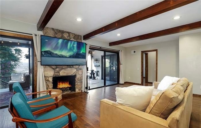
- Fireplace
- Fenced Lot
- Security System

About This Home
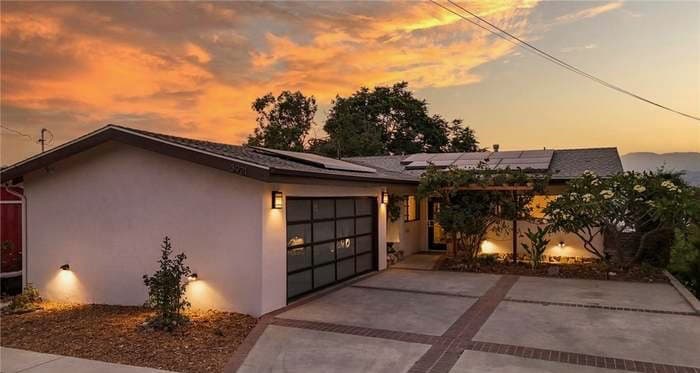
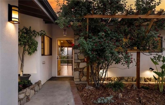
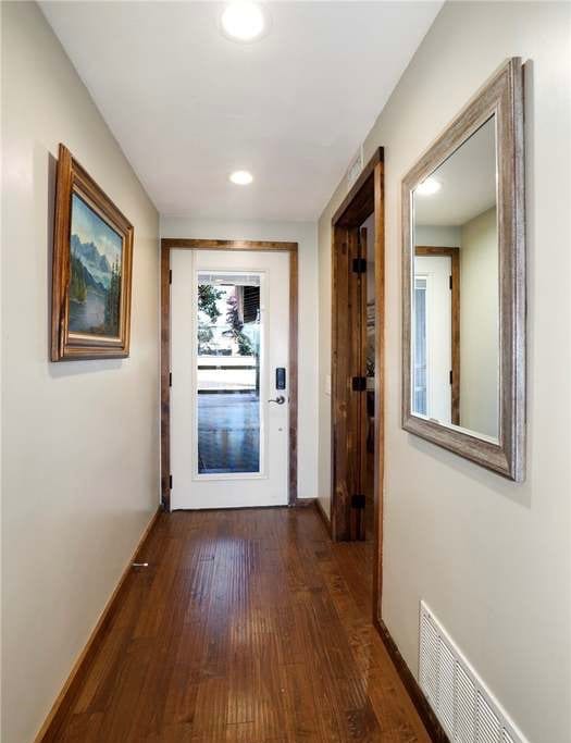
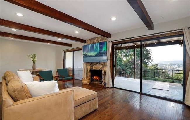
Property Id: 2095480 Welcome to 3921 Paige Street — a stylish 3-bed, 2-bath hillside retreat in Montecito Heights with breathtaking views and modern upgrades throughout. Step inside to sunlit open living with maple hardwood floors, custom finishes, and seamless indoor-outdoor flow to a covered deck perfect for relaxing or entertaining. Enjoy energy efficiency and peace of mind with owned solar, smart home tech, security features, and dual EV chargers. The flat backyard is a private paradise with fruit trees, a trampoline, and fragrant jasmine. Just minutes from downtown yet surrounded by nature and trails, this rare home offers the perfect blend of comfort, convenience, and escape.
3921 Paige St is a house located in Los Angeles County and the 90031 ZIP Code. This area is served by the Los Angeles Unified attendance zone.
House Features
Washer/Dryer
Dishwasher
Hardwood Floors
Microwave
- Washer/Dryer
- Security System
- Fireplace
- Dishwasher
- Disposal
- Microwave
- Oven
- Refrigerator
- Freezer
- Hardwood Floors
- Vaulted Ceiling
- Furnished
- Spa
- Bicycle Storage
- Fenced Lot
- Lawn
Fees and Policies
The fees below are based on community-supplied data and may exclude additional fees and utilities.
- Dogs Allowed
-
Fees not specified
- Cats Allowed
-
Fees not specified
- Parking
-
Garage--
Details
Utilities Included
-
Water
-
Electricity
Property Information
-
Furnished Units Available
Contact
-
Source

- Washer/Dryer
- Security System
- Fireplace
- Dishwasher
- Disposal
- Microwave
- Oven
- Refrigerator
- Freezer
- Hardwood Floors
- Vaulted Ceiling
- Furnished
- Fenced Lot
- Lawn
- Spa
- Bicycle Storage
Situated in northeast Los Angeles, just four miles from downtown, Montecito Heights sits atop a hilly landscape separating LA from the San Gabriel Valley. From the neighborhood’s steep hills, you can catch stunning views of downtown and the San Gabriel Valley in addition to the Arroyo Seco and even the Pacific Ocean (on a clear day).
Montecito Heights is known for its secluded feel despite being minutes away from Downtown LA. Natural beauty and lush parks abound in Montecito Heights. Ernest E. Debs Regional Park is one of the neighborhood’s defining features, touting 300 acres of scenic hiking trails, biking paths, picnic tables, a peaceful pond, and the striking panoramic views the neighborhood is revered for.
Montecito Heights is also home to the Heritage Square Museum, a living history museum that details life in 19th-century Southern California.
Learn more about living in Montecito Heights| Colleges & Universities | Distance | ||
|---|---|---|---|
| Colleges & Universities | Distance | ||
| Drive: | 11 min | 3.5 mi | |
| Drive: | 12 min | 4.1 mi | |
| Drive: | 14 min | 5.2 mi | |
| Drive: | 12 min | 5.5 mi |


View GreatSchools Rating Methodology
Data provided by GreatSchools.org © 2025. All rights reserved.
Transportation options available in Los Angeles include Southwest Museum Station, located 1.9 miles from 3921 Paige St. 3921 Paige St is near Bob Hope, located 17.1 miles or 26 minutes away, and Los Angeles International, located 20.2 miles or 34 minutes away.
| Transit / Subway | Distance | ||
|---|---|---|---|
| Transit / Subway | Distance | ||
|
|
Drive: | 6 min | 1.9 mi |
|
|
Drive: | 7 min | 2.2 mi |
|
|
Drive: | 8 min | 2.7 mi |
|
|
Drive: | 7 min | 2.9 mi |
|
|
Drive: | 10 min | 4.5 mi |
| Commuter Rail | Distance | ||
|---|---|---|---|
| Commuter Rail | Distance | ||
|
|
Drive: | 11 min | 5.1 mi |
|
|
Drive: | 13 min | 5.2 mi |
|
|
Drive: | 13 min | 6.4 mi |
| Drive: | 15 min | 9.2 mi | |
|
|
Drive: | 23 min | 13.4 mi |
| Airports | Distance | ||
|---|---|---|---|
| Airports | Distance | ||
|
Bob Hope
|
Drive: | 26 min | 17.1 mi |
|
Los Angeles International
|
Drive: | 34 min | 20.2 mi |
Time and distance from 3921 Paige St.
| Shopping Centers | Distance | ||
|---|---|---|---|
| Shopping Centers | Distance | ||
| Drive: | 7 min | 2.2 mi | |
| Drive: | 7 min | 2.3 mi | |
| Drive: | 7 min | 2.4 mi |
| Parks and Recreation | Distance | ||
|---|---|---|---|
| Parks and Recreation | Distance | ||
|
Audubon Center at Debs Park
|
Drive: | 4 min | 1.1 mi |
|
Chavez Ravine Arboretum
|
Drive: | 10 min | 4.8 mi |
|
Elysian Park
|
Drive: | 13 min | 4.9 mi |
|
Elyria Canyon Park
|
Drive: | 12 min | 5.1 mi |
|
Marsh Park
|
Drive: | 13 min | 5.4 mi |
| Hospitals | Distance | ||
|---|---|---|---|
| Hospitals | Distance | ||
| Drive: | 10 min | 3.6 mi | |
| Drive: | 12 min | 4.5 mi | |
| Drive: | 11 min | 4.8 mi |
| Military Bases | Distance | ||
|---|---|---|---|
| Military Bases | Distance | ||
| Drive: | 31 min | 21.7 mi | |
| Drive: | 44 min | 29.2 mi |
You May Also Like
What Are Walk Score®, Transit Score®, and Bike Score® Ratings?
Walk Score® measures the walkability of any address. Transit Score® measures access to public transit. Bike Score® measures the bikeability of any address.
What is a Sound Score Rating?
A Sound Score Rating aggregates noise caused by vehicle traffic, airplane traffic and local sources

3921 Paige St
Los Angeles, CA 90031